
Overview
เทศบาลนครลำปาง เป็นเทศบาลนครแห่งหนึ่งในภาคเหนือของประเทศไทย ตั้งอยู่ในบริเวณอำเภอเมืองลำปาง จังหวัดลำปาง เป็นเทศบาลนครที่จัดตั้งขึ้นเป็นลำดับที่สองในภาคเหนือ ถัดจากเทศบาลนครเชียงใหม่ เป็นศูนย์กลางเศรษฐกิจและความเจริญของจังหวัดลำปางและภาคเหนือ เป็นประตูสู่ดินแดนห้าเชียง อันได้แก่ เชียงใหม่, เชียงราย, เชียงตุง (พม่า), เชียงรุ่ง, และเชียงทอง (หลวงพระบาง) ทั้งนี้เดิมเทศบาลนครลำปางมีความเจริญและประชากรเป็นลำดับที่สองของภาคเหนือรองจากเทศบาลนครเชียงใหม่ ปัจจุบันเมื่อเทศบาลนครเชียงรายมีความเจริญและประชากรมากจนแซงหน้าเป็นอันดับที่สองของภาคเหนือ จึงทำให้เทศบาลนครลำปางมีความเจริญและประชากรมากเป็นอันดับที่สามของภาคเหนือจวบจนปัจจุบัน
Interested in working with us in the future?
Follow to see new jobs and posts in your feed.
No news yet.
About

เทศบาลนครลำปาง เป็นเทศบาลนครแห่งหนึ่งในภาคเหนือของประเทศไทย ตั้งอยู่ในบริเวณอำเภอเมืองลำปาง จังหวัดลำปาง เป็นเทศบาลนครที่จัดตั้งขึ้นเป็นลำดับที่สองในภาคเหนือ ถัดจากเทศบาลนครเชียงใหม่ เป็นศูนย์กลางเศรษฐกิจและความเจริญของจังหวัดลำปางและภาคเหนือ เป็นประตูสู่ดินแดนห้าเชียง อันได้แก่ เชียงใหม่, เชียงราย, เชียงตุง (พม่า), เชียงรุ่ง, และเชียงทอง (หลวงพระบาง) ทั้งนี้เดิมเทศบาลนครลำปางมีความเจริญและประชากรเป็นลำดับที่สองของภาคเหนือรองจากเทศบาลนครเชียงใหม่ ปัจจุบันเมื่อเทศบาลนครเชียงรายมีความเจริญและประชากรมากจนแซงหน้าเป็นอันดับที่สองของภาคเหนือ จึงทำให้เทศบาลนครลำปางมีความเจริญและประชากรมากเป็นอันดับที่สามของภาคเหนือจวบจนปัจจุบัน
Kaynak: Wikipedia · CC BY-SA 4.0
ประวัติ
เทศบาลนครลำปาง เดิมเป็นสุขาภิบาลเมืองลำปาง ได้รับการยกฐานะขึ้นเป็นเทศบาลตามพระราชกฤษฎีกาจัดตั้งเทศบาลเมืองลำปาง ในวันที่ 25 มีนาคม 2478 มีพื้นที่ 10.86 ตารางกิโลเมตรครอบคลุมพื้นที่ 4 ตำบล คือ ตำบลสวนดอก ตำบลเวียงเหนือ ตำบลหัวเวียง และตำบลสบตุ๋ย เมื่อวันที่ 24 ตุลาคม พ.ศ. 2534 ได้มีพระราชกฤษฎีกาเปลี่ยนแปลงเขตพื้นที่การปกครองของเทศบาลเมืองลำปางใหม่ ได้ขยายอาณาบริเวณของเทศบาลเพิ่มขึ้นอีก 11.31 ตารางกิโลเมตร รวมเป็นพื้นที่ทั้งสิ้น 22.17 ตารางกิโลเมตร ครอบคลุมพื้นที่ตำบลเพิ่มอีก 4 ตำบล คือ ตำบลบ่อแฮ้ว 1.16 ตารางกิโลเมตร, ตำบลชมพู 3.80 ตารางกิโลเมตร, ตำบลพระบาท 6.13 ตารางกิโลเมตร และตำบลพิชัย 0.22 ตารางกิโลเมตร เมื่อในวันที่ 10 พฤศจิกายน พ.ศ. 2542 ได้มีพระราชกฤษฎีกาเปลี่ยนแปลงจากเทศบาลเมืองลำปาง จัดตั้งเป็นเทศบาลนครลำปาง (ประกาศในราชกิจจานุเบกษา ฉบับกฤษฎีกา เล่ม 116 ตอนที่ 10 ก.) มีผลใช้บังคับตั้งแต่วันที่ 11 พฤศจิกายน พ.ศ. 2542 เป็นต้นไป ครอบคลุมพื้นที่อาณาบริเวณ 8 ตำบล รวมทั้งสิ้น 22.17 ตารางกิโลเมตร นับว่าเป็นเทศบาลนครแห่งที่สองของภาคเหนือตอนบนถัดจากเทศบาลนครเชียงใหม่
ตราสัญลักษณ์
ตราสัญลักษณ์ของเทศบาลนครลำปางใช้ตราไก่ขาวเช่นเดียวกับตราจังหวัดลำปาง ที่มาตามตำนานพระฤๅษี 5 พระองค์ได้กล่าวไว้ว่า เดิมเมืองนครลำปางมีชื่อว่า "กุกุฎฎะนคร" แปลว่า เมืองไก่ขาว มีที่มาตามตำนานว่า ในสมัยพุทธกาลเมื่อพระบรมศาสดาสัมมาสัมพุทธเจ้าได้ตรัสรู้สัมโพธิญาณแล้วได้เสด็จโปรดสัตว์ผ่านมาทางบริเวณลัมภะกัมปะกาลิณี คือนครลำปางในปัจจุบัน พระอินทร์ได้แปลงกายลงมาเป็นไก่ขาวเพื่อเตือนให้ชาวเมืองตื่นขึ้นมาบำเพ็ญทาน พระพุทธองค์ทรงทำนายว่าต่อไปเมื่อหน้าบริเวณแห่งนี้จะเป็นนครอันรุ่งเรือง ต่อมาได้มีผู้มาสร้างเมืองขึ้นบริเวณนี้และได้ตั้งชื่อเมืองแห่งนี้ว่า "เมืองกุกุฎฏะนคร" ซึ่งแปลว่าเมืองไก่ขาว
การขนส่ง
การคมนาคมเข้าสู่เทศบาลนครลำปางมีเส้นทางหลัก ซึ่งเป็นทางหลวงแผ่นดินที่สำคัญ คือ ทางหลวงแผ่นดินหมายเลข 1 ถนนพหลโยธิน จากกรุงเทพมหานครถึงจังหวัดลำปาง เป็นระยะทาง 600 กิโลเมตร นอกจากนี้ยังมีสามารถเลือกเดินทางโดยรถไฟ จากสถานีหัวลำโพง สู่สถานีรถไฟนครลำปาง รวมระยะทาง 640 กิโลเมตร และมีทางหลวงจังหวัดเชื่อมโยงระหว่างอำเภอต่าง ๆ และจังหวัดเชียงใหม่เป็นเส้นทางที่สะดวก
การคมนาคมทางอากาศ มีสนามบินพาณิชย์ภายในประเทศซึ่งมีบริการเที่ยวบินสายการบินภายในประเทศ 1 สายการบินคือ ไทยแอร์เอเชีย วันละ 1-2 เที่ยวบิน
การขนส่งในเขตเทศบาล
สภาพการจราจร ปัจจุบันในเขตเทศบาลมีปัญหาการจราจรติดขัดเฉพาะในชั่วโมงเร่งด่วน และในช่วงเทศกาลสำคัญต่าง ๆ ซึ่งเทศบาลนครลำปาง เป็นศูนย์กลางประตูสู่ภาคเหนือตอนบน สามารถเดินทางไปได้ทุกจังหวัดในภาคเหนือตอนบนไม่ว่าจะเป็นแม่ฮ่องสอน เชียงใหม่ เชียงราย ลำพูน พะเยา แพร่ น่าน และการเชื่อมถนนรอบนอกกับถนนรอบในยังเป็นถนนเล็ก ๆ ซึ่งจะต้องปรับปรุงโครงข่ายถนนให้เพียงพอกับปริมาณรถและความเจริญของชุมชน.
ปัจจุบันนิยมใช้การจราจรโดยรถส่วนบุคคลหรือรถจักรยานยนต์รวมทั้งจักรยาน สำหรับระบบมวลชน จะมีรถสองแถวรอบเวียงสีเหลือง และมีรถตู้เชื่อมระหว่างตัวจังหวัดไปยังตัวอำเภอต่าง ๆ ทั้ง 13 อำเภอ และเดินทางข้ามจังหวัดที่สถานีขนส่งผู้โดยสารจังหวัดลำปาง ติดถนนสายเอเชียสายนอก
การศึกษา
โรงเรียนสังกัดเทศบาลนครลำปาง มี 6 โรงเรียนได้แก่
โรงเรียนเทศบาล 2 (บ้านปงสนุก) ในปัจจุบันได้โอนเป็นสถานศึกษาในสังกัด สพฐ. มีชื่อว่า โรงเรียนบ้านปงสนุก
Kaynak: Wikipedia – เทศบาลนครลำปาง · CC BY-SA 4.0
Geography

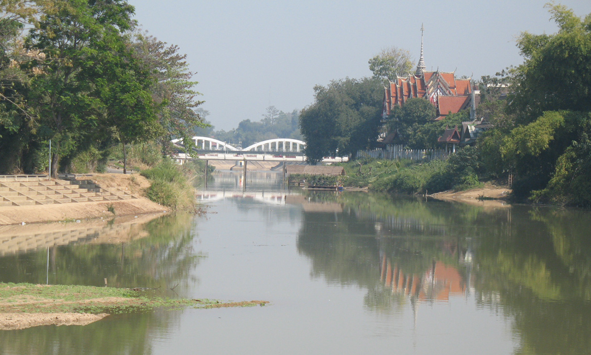
Lampang city is in the valley of the Wang River, bordered by the Khun Tan Range on the west and the Phi Pan Nam Range on the east. The river, a major tributary of the Chao Phraya, flows through the city. The city lies mainly on the south side of Wang River, although the old parts of the city had been originally developed in the north side of it. Nowadays, downtown Lampang has grown in the southeast of the river along Bunyawat and Pahon Yothin Roads.
History

Lampang was a major city in the Lanna kingdom. However, its historical prominence is largely overshadowed by Chiang Mai or Chiang Rai which were the traditional seats of government, and whose histories were well recorded in chronicles. Following decades of warfare with both the Ava Burmese and Ayudhya during the 17th-18th century, the region was in decline, severely depopulated, and subject to Burmese control.
In the late 18th century, the famed marksman and Lampang native Nan Thipchang assassinated the local Burmese leader in Wat Phra That Lampang Luang, and led an uprising which led to a rollback of Burmese rule over Lanna. Allied with Bangkok, the descendants of Nan Thipchang, known as Chao Ched Ton (the seven princes), became the vassal rulers of the various Lanna cities until the annexation of Lanna into Siam (Thailand) proper under King Chulalongkorn (Rama V).
Modern history
During the late 1800s and early 1900s, the region experienced a growth in teak logging. Lampang later became home to Louis Leonowens, who operated teak plantations around Lampang. During the Ngiao Rebellion, Lampang was attacked by 200 Shan rebels led by Phaka Mong on 3 August 1902. Prior to this, the ruler of Lampang assembled a force of 1,000 and Leonowens had organized defences around the town. They were also reinforced by 54 policemen from Chiang Mai led by Danish captain Hans Markvard Jensen. The following battle resulted in the defeat of the Shans, however Chao Bunwatwongse, Lampang's ruler, was evacuated to Chiang Mai over fears of another attack but returned to Lampang on August 7.
In 1894, the Ratsadaphisek Bridge across the Wang river was opened and became the longest bridge in Thailand at the time. However, the flow of logs down the Wang caused damage to the bridge until the current version was completed in 1917. On 1 April 1916, the first train arrived at Nakhon Lampang Railway Station, which was then the northernmost train station in Thailand.
Climate
Lampang has a relatively dry climate relative to nearby provinces. "Winter" starts after the last rains, typically November, and lasts until March. Cold air masses from Siberia sometimes lead to nighttime temperatures below 10 °C (50 °F), although that is quite rare. Winter is characterized by dry, sunny, and quite pleasant days, and cool and occasionally foggy nights. In recent times, the blue winter sky is often marred by the practice of burning the fields after the harvest, as well as the smog generated by Mae Mo coal-fired power plants.
Summer typically runs from March until June. The temperature could soar to 40–43 °C (104–109 °F) in April. Late afternoon thunderstorms and hailstorms are frequent.
Rainy season runs from June until November, and significant rain may occur in May as well. Being in a relative rain shadow, Lampang receives less precipitation than neighboring provinces and rarely suffers from the flooding which has plagued Chiang Mai in recent years.
Economy
Besides the traditional rice paddy farming, pineapple, and sugarcane constitute major food crops in Lampang Province. The province has a large deposit of lignite in Mae Moh district, fuelling several coal-fired electricity generating plants, whose pollution has severely affected the local populations. Lampang also has a large deposit of kaolin which is widely utilized in the ceramics industry. Historically, logging was an important industry, since Lampang, together with nearby Phrae had a large stand of teak. Many elephants were employed to transport the logs to the river for transport to Bangkok, hence the founding of an "elephant school", the predecessor of the Thai Elephant Conservation Center. Much of the old growth teak stands in Lampang had been thoroughly harvested.
Culture
Lampang, also called "mueang rot ma" in Thai, meaning "horse carriage city", is considered by some Thais as the last paradise in Thailand. It is about 100 km (62 mi) to the southeast of Chiang Mai. Although well-connected by rail, and four lane highways to both Bangkok and Chiang Mai, it is here that tourists can still find horse-drawn carriages in regular use for transportation. One account attributes the horse-drawn carriage to the Portuguese, via Macau, although a more likely origin is colonial Burma. Lampang was an important center of the timber industry in the early-20th century and saw an influx of migrants from British-controlled Burma. The horse-drawn carriage is one of the most memorable symbols of Lampang, as reflected in many traditional products.
Lampang has a few institutions of higher learning, such as Yonok College, and a branch of Thammasat University.
Health
The main hospital of Lampang is Lampang Hospital, operated by the Ministry of Public Health.
Transportation
The city is an important highway hub, with a four lane highway link to Chiang Mai and Chiang Rai, as well as a major highway to Phrae and the eastern Lanna provinces. Lampang is roughly a 1.5 hour bus ride to Chiang Mai. Nakhon Lampang railway station is a stop for the Chiang Mai-bound train, approximately 10 hours from Bangkok.
Lampang Airport is served by Bangkok Airways (three flights daily to Suvarnabhumi Airport) and Nok air (four flights daily to Don Mueang) (Oct 2015).
Landmarks and tourist attractions

Tourists typically stop by for lunch and visit the more famous attractions such as Wat Phra That Lampang Luang and the Thai Elephant Conservation Center and then proceed to points further north such as Chiang Mai or Chiang Rai. Less well-known tourist attractions in Lampang are thus mostly visited by locals. Among these are the Wang Kaeo Waterfall and the Chae Son National Park, a compact park which combines a natural hot spring with large waterfalls.
Many temples in downtown Lampang were built in the Burmese -style, originally endowed by the logging tycoons of the late-19th century. Wat Si Bun Rueang, Wat Si Chum and Wat Pa Fang are among the extant examples. Nine of the 31 remaining Burmese-style temples in Thailand are in Lampang. Traditional Lanna architecture can be found at Wat Phra That Lampang Luang, on the site of ancient Lampang city. It is famous for its murals from the 19th century. The city seal features a white rooster in the temple's gate.
Wat Phra Kaeo Don Tao, on the west bank of the Wang River, is said to have housed the Emerald Buddha between 1436 and 1468. Wat Phra That Chedi Sao (The Temple of Twenty Chedis) is famous for its array of twenty pagodas. Other temples of some renown include Wat Phra That Chom Ping and Wat Lai Hin both in the Ko Kha District.
Mae Mo mine is a vast open pit lignite mine in the Mae Mo basin. The mine and the adjoining power generation facilities are operated by EGAT. The power plant is a major source of electric power for Thailand.
Lampang is known for its horse-drawn carriages, which were introduced in 1916 and remain popular with tourists.
Education
Lampang has a number of educational institutions, including kindergartens, primary, secondary and vocational schools. Schools teach in the English, Thai, and Chinese languages. Lampang also has a number of universities: Lampang Rajabhat University, Rajmangala University of Technology, Nation University (formerly Yonok) and a satellite campus of Thammasat University. Lampang College of Commerce and Technology (LCCT) and Lampang International Technical College (LIT) are well known schools which teach technology.
Kaynak: Wikipedia – Lampang · CC BY-SA 4.0