

Overview
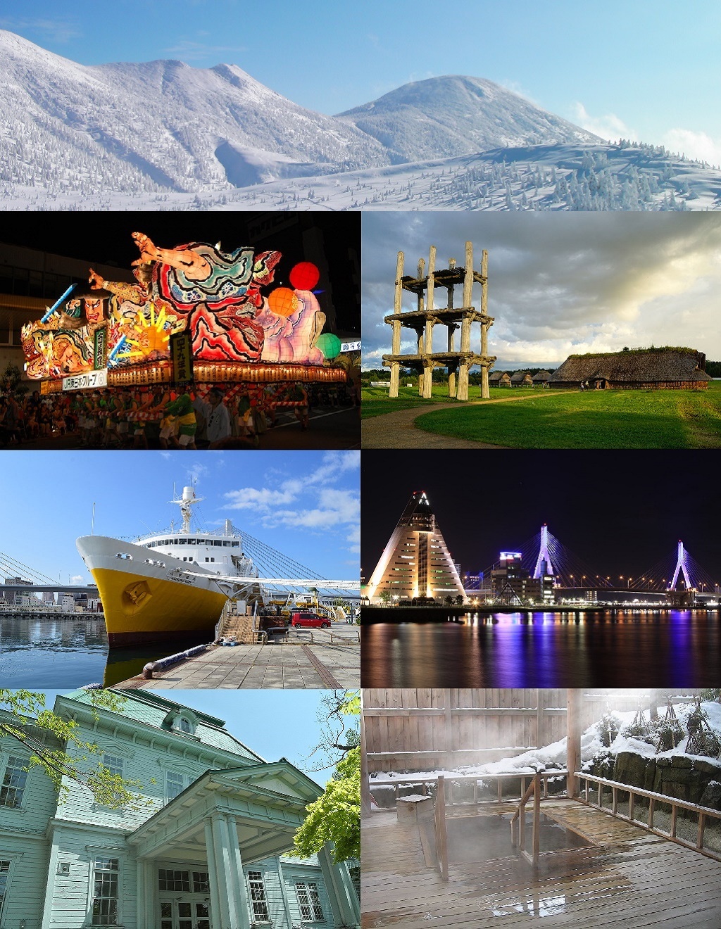
青森市(あおもりし)は、青森県の津軽地方・東青地域にある市。青森県の県庁所在地および人口が最多の都市であり、県内では八戸市とともに中核市に指定されている。面積はむつ市に次いで県内2位。
Interested in working with us in the future?
Follow to see new jobs and posts in your feed.
No news yet.
About

青森市(あおもりし)は、青森県の津軽地方・東青地域にある市。青森県の県庁所在地および人口が最多の都市であり、県内では八戸市とともに中核市に指定されている。面積はむつ市に次いで県内2位。
Kaynak: Wikipedia · CC BY-SA 4.0
概要

本州最北の県である青森県のほぼ中央に位置する。県の西半部を指す津軽地方においては北東部に位置し、東津軽郡の町村と東青地域を構成する。青森平野を中心とし、北は陸奥湾の支湾である青森湾に面し、南部から東部にかけては奥羽山脈の北端部にあたる八甲田山・東岳山地の山が連なり、西部で市域は津軽半島の脊梁山脈である梵珠山地や津軽平野に広がる。市街地は青森湾沿いの中心市街地から青森平野上を扇状に展開しており、行政都市・商業都市・交通都市・港湾都市の性格を有する。1999年の 「青森都市計画マスタープラン」において「コンパクトシティの形成」を掲げ、都市機能を郊外から中心市街地へ集積することを目指し、「都市のコンパクト化」による効率的で効果的な都市づくりに取り組んでいる。
東北地方を縦貫する路線および本州と北海道をつなぐ路線の結節点であり、北日本における交通・物流における要衝である。西の津軽半島と東の夏泊半島に抱かれた青森湾奥に青森港があり、函館港(北海道函館市)との青函航路をフェリーが運航している。鉄道は新青森駅が東北新幹線の終点、北海道新幹線の起点となっている。また、青い森鉄道線(旧東北本線)と奥羽本線が青森駅で合流して終点となり、津軽線が津軽半島の青森湾沿いを北に延びている。道路は東北自動車道が青森インターチェンジで終点となり、国道4号と国道7号も中心部で終点となって接続している。南西部の丘陵地には青森空港がある。
陸奥湾はその大きさに対して湾口である平舘海峡の幅が狭いため外洋の影響を受けにくい。湾外から入った波浪は広い湾内で拡散するため、波高が小さく穏やかで、また潮汐によって流入または流出する海水が限られるため干満差も小さい。こうした安定的な海域環境は養殖業や港湾に適し、沿岸ではホタテの養殖が営まれ、湾奥の青森港は岩礁もなく静穏度が高い天然の良港となっている。
南東部の八甲田山一帯は十和田八幡平国立公園に指定されており、四季を通じた観光地となっている。北東部の浅虫地区は浅虫夏泊県立自然公園に指定されている。市内には温泉が多く、八甲田山麓の酸ヶ湯や湾岸の浅虫温泉などがある。
人口動態概要
2026年現在約25万人となっており1967年とほぼ同じ人口規模となっている。人口は2001年をピークに減少に転じている。青森市の人口は戦後順調に増加を果たして、特に1970年代は年間5,000人前後の人口増加を数えた。人口増加の大半はこの時期までによるものである。80年以降から2000年までにかけては横ばいで推移していたが、2000年以降は年々人口減少が大きくなっている。近年は県庁所在地でワーストの人口減少率を記録するなど厳しい状況に直面している。
2015年の国勢調査における人口は2位の八戸市、3位の弘前市を抑え県内1位だった。また前回調査からの人口増減率はマイナス3.96%で長崎市のマイナス3.21%、甲府市のマイナス2.95%を上回り、県庁所在地としては最大の減少率だった。
地理

地形
山地は青森平野を囲むように存在し、奥羽山脈に属する南部の八甲田火山地と東部の東岳山地、および津軽山地に属する西部の梵珠山地に分けられる。田代平湿原がある田代平は八甲田カルデラ(田代平カルデラ、先八甲田カルデラ)のカルデラ湖の跡であり、その北東の山列はカルデラの外輪山。八甲田山はカルデラに噴出した南北2つの中央火口丘群の総称であり、約20体の火山体で構成される。
北八甲田:大岳、高田大岳、井戸岳、赤倉岳、小岳、硫黄岳、田茂萢岳、前嶽、雛岳、石倉岳
丘陵地は八甲田山の山麓部になっている火山性の八甲田火山丘陵と梵珠山地の山麓部になっている非火山性の大釈迦丘陵がある。
青森平野は主要部の深沢平野と北西部の上磯平野に分けられる。深沢平野は堤川などによって形成された沖積平野で、上磯平野は海底が隆起した海岸平野。島は浅虫地区に湯ノ島と裸島がある。
河川・湖沼
四戸橋川、六枚橋川、内真部川、奥内川、瀬戸子川、天田内川、新城川、赤川、沼川、野内川、貴船川、根井川、浅虫川
ダム湖:下湯平成湖(下湯ダム貯水池)、浅虫ほたる湖(浅虫ダム貯水池)、浪岡ダム貯水池、本郷ダム貯水池
気候
寒暖の差が大きく気温の年較差、日較差が大きい顕著な大陸性気候である。青森市全域が特別豪雪地帯に指定されている。
青森の気候
年平均気温は10.7℃である。平年値では猛暑日が0.4日、真夏日が14.7日、夏日が65.8日、熱帯夜が0.6日、真冬日が18.7日、冬日が102.5日となっている。また、1月から2月にかけて日平均気温が氷点下となっている。
冬季は、近年でも-10℃を下回る気温が観測され、2018年2月2日に-10.7℃を観測している。
青森大谷の気候
年平均気温は9.0℃である。平年値では猛暑日が0.1日、真夏日が9.6日、夏日が53.0日、熱帯夜が0.1日、真冬日が41.1日、冬日が139.7日となっている。また、12月から2月にかけて日平均気温が氷点下となっている。
冬季は、近年でも-15℃を下回る気温が観測され、2014年1月17日に-16.0℃、2014年1月18日に-17.6℃、2018年2月2日に-17.7℃を観測している。
酸ケ湯の気候
ケッペンの気候区分では、酸ケ湯は湿潤大陸性気候・亜寒帯湿潤気候(Dfb)に属する。
年平均気温は5.2℃である。平年値では猛暑日が0.0日、真夏日が0.0日、夏日が9.9日、熱帯夜が0.0日、真冬日が98.6日、冬日が163.2日となっている。また、12月から3月にかけて日平均気温が氷点下となっている。
1月の日最高気温は-5.1℃と、気象庁により気象観測が行われている日本の観測所としては富士山に次いで日最高気温が低い。
年平均降雪量は1706cmと、気象庁により気象観測が行われている日本の観測所としては、最も年平均降雪量が多い。
歴史

前近代
縄文時代には集落が築かれていた(三内丸山遺跡)。室町時代には南部氏支族である堤氏の領地であった。堤氏は戦国時代末期に津軽氏に攻め滅ぼされ、外ヶ浜は弘前藩の領地となった。青森は弘前藩(津軽藩)初代藩主津軽為信のときに開港が計画されたといわれ、構想を引き継いだ2代藩主津軽信枚とその家臣である森山弥七郎によって寛永期に港町が築かれ、その後商港および北方との交通港として発展した。
居城弘前城の建設(慶長16年〈1611年〉)と城下町弘前の整備を終えた弘前藩は江戸との海運を目的とした港の開発を企図した。信枚は森山を開港奉行に任じ、寛永元年(1624年)善知鳥村(うとうむら、青森の古名)に港を開いたが(廻船運航の許可を得た寛永2年(1625年)または町割りがされた寛永3年(1626年)が開港年とされることもある)、このとき海岸付近にハイネズ(浜松・磯馴松(そなれまつ))が繁茂する高さ一丈(約3メートル)ほどの小丘があり、「青森」と呼ばれて漁船が帰るときの目標物になっていたことから、開港に際してその名を採って青森村と改称した。次いで寛永3年(1626年)に信枚は森山に青森の町づくりを命じ、浜町・本町(大町)・米町の3町がつくられ、青森町が成立した(当時は「青盛町」との表記もあった)。同年、土地と建築資材の無償提供、10年間の免税などの条件が示されて移住が奨励されると、近江・越前などから移住が相次ぎ、開港からわずか数年で戸数1000ほどの町が形成された。
浪岡には室町時代北畠親房の子孫が移り住み(浪岡北畠氏)、浪岡城を拠点に戦国大名化して北津軽・東津軽に勢力を張ったが、大浦為信(津軽為信)に攻め滅ぼされた。江戸時代、青森と弘前の中間に位置する浪岡は羽州街道の宿場として栄え、多くの人や物資が行き交った。
縄文時代前期中葉 - 中期末葉(約5500年 - 4000年前) - 三内丸山遺跡(特別史跡)の集落が繁栄する。
縄文時代後期前半(約4000年前) - 小牧野遺跡(国の史跡)の環状列石が構築される。
平安時代(10世紀ごろ - 12世紀ごろ) - 高屋敷館遺跡(国の史跡)の環壕集落。
文治06年(1190年) - 大河兼任軍と鎌倉軍が善知鳥前の梯(現在の善知鳥崎)で戦う。
応仁年間(1467年 - 1468年) - 浪岡北畠氏、浪岡城(国の史跡)を構築。
天正06年(1578年)7月 - 浪岡城、大浦為信(津軽為信)に攻められて落城。
天正13年(1585年)3月 - 大浦為信、外が浜にある油川城を攻略。一帯は大浦氏(津軽氏)の領有となる。
寛永02年5月15日(1625年6月19日) - 弘前藩、津軽から江戸へ廻船を運航する許可を幕府より得る。
寛永03年4月6日(1626年5月1日) - 弘前藩、森山弥七郎に町づくりを命じる。
寛文11年(1671年) - 仮屋(藩の出先施設)が設置される。元治元年(1864年)から陣屋と称し明治2年(1869年)に仮屋にもどした。
近現代
明治4年7月14日(1871年8月29日)の廃藩置県で弘前藩は弘前県となる。政府は同年9月4日、弘前県に七戸県、八戸県、斗南県、黒石県、館県の5県を併合し( 太政官布告『七戶八戶斗南黑石館ノ五縣ヲ弘前縣ニ併ス』。ウィキソースより閲覧。 )、翌9月5日に熊本藩出身の野田豁通を大参事(知事)に任命した。野田は箱館戦争の際に官軍の拠点となった青森町に駐在した経験から当地の地勢に通じており、県域の中央に位置し、港もあって各方面への交通に利便がある青森町に県庁を置くよう、大参事就任前に政府に伺書を提出していた。政府は野田の建言を受け入れ、直後の9月23日に県庁を青森町に置くことを定めて県名も青森県に改めた( 太政官布告『弘前縣ヲ靑森ニ移シ靑森縣ト改稱』。ウィキソースより閲覧。 )。
1873年(明治6年)3月に大区小区制が実施されて第一大区一小区となった。以下の青森27町で構成された。
1878年(明治11年)の郡区町村編制法では、10月30日に大区小区制が廃止されて第一大区は東津軽郡となった。1883年(明治16年)に第一組戸長役場が設置されて青森18町を所管した。役場の名称は1884年(明治17年)11月から青森安方町外十七ケ町戸長役場となった。
1889年(明治22年)の市制・町村制の実施(明治の大合併)では、従来の青森18町に造道村から独立していた栄町と造道村字浪打・大野村字長嶋を加えた区域をもって4月1日に町制を施行し、青森町(あおもりまち)が発足した。
議会
衆議院
選挙区:青森1区(青森市、むつ市、東津軽郡、上北郡(野辺地町、横浜町、六ケ所村)、下北郡)
行政機関
県の機関
東青地域県民局(青森市と東津軽郡を所管)が置かれていたが、各地域県民局は2025年(令和7年)3月31日で廃止された(本庁所管部ごとに各圏域に個別に各事務所(地域連携事務所や県税事務所、環境管理事務所など)を設置している)。

対外関係
国内
1989年(平成元年)3月13日 - ツインシティ(双子都市)提携。文化、スポーツ、観光、経済などの交流
2000年(平成12年)8月5日 - 浪岡町・上屋久町、友好盟約を締結。教育、文化、経済などの交流
海外
1994年(平成6年)11月18日 松炭市と「教育・文化等の友好交流に関する協定」を締結
1995年(平成7年)8月28日 松炭市を統合した平澤市と改めて「教育・文化等の友好交流に関する協定」を締結
2004年(平成16年)12月24日 「青森市・大連市経済文化交流委員会設置に関する協定」を締結
国際
世界冬の都市市長会(旧・北方都市会議) - 1992年にカナダのモントリオールで開催された第5回会議から正式参加
経済
第一次産業:99億2800万円、第二次産業:1086億1600万円、第三次産業:9341億3400万円
第一次産業:5724人(4.0%)、第二次産業:2万3147人(16.2%)、第三次産業:11万1754人(78.2%)
農業
特に浪岡地区で生産が盛んで、市町村別出荷量は全国第3位(平成17年)となっている。
国内生産量の90パーセントを占める。青森市の気候に適した作物として特産品化が進められている。
教育
大学
青森県立保健大学 - 設置者:公立大学法人青森県立保健大学(法人の設立団体:青森県)
交通

青森市は東北以北の県道庁所在地で唯一、市内にフル規格新幹線、空港、高速道路、港が揃う都市であり、北日本における交通の要衝となっている。
鉄道・索道
奥羽本線:浪岡駅 - 大釈迦駅 - 鶴ケ坂駅 - 津軽新城駅 - 新青森駅 - 青森駅
津軽線:青森駅 - 油川駅 - 津軽宮田駅 - 奥内駅 - 左堰駅 - 後潟駅 - 中沢駅
青い森鉄道線:浅虫温泉駅 - 野内駅 - 矢田前駅 - 小柳駅 - 東青森駅 - 筒井駅 - 青森駅
道路
市道 - 5,916路線、実延長:1,794,250m(平成20年4月1日現在)
バス
青森駅・柳町通り・青森大野 - 羽黒平 - 牡丹平 - 碇ヶ関 - 小坂 - 花輪 - 盛岡駅
観光

自然
ハクチョウ(浅虫・久栗坂地域) - 特別天然記念物「小湊のハクチョウおよびその渡来地」
歴史・遺跡・社寺・記念碑
縄文時代前期中葉 - 中期末葉(約5500年 - 4000年前)に繁栄した集落の跡を中心とする遺跡
その他
三内丸山架道橋 - 支間長150mはコンクリート鉄道橋として、また新幹線橋として日本最長
文化・名物

祭事・催事
青森ねぶた祭(8月2日 - 8月7日) - 重要無形民俗文化財。東北三大祭りの1つ。
参考文献
長谷川成一ほか『青森県の歴史』児玉幸多監修(第1版第1刷)、山川出版社〈県史〉、2000年2月25日。ISBN 4634320207。 NCID BA45501953。
宮崎道生『青森県の歴史』児玉幸多監修(2版10刷)、山川出版社〈県史シリーズ〉、1982年8月15日(原著1970年7月7日)。ISBN 4634230208。 NCID BN06471435。
青森市史編さん委員会 編集『青森市の歴史』(四版)青森市、1991年10月1日。
青森市文化団体協議会・編『あおもり文化一〇〇年の軌跡』青森市文化団体協議会、2001年9月9日。ISBN 4-87373-112-7。
Kaynak: Wikipedia – 青森市 · CC BY-SA 4.0
Kardeş şehirler
Kecskemét, Macaristan (Ağustos 1994'ten beri)
Hsinchu ilçesi, Tayvan (Ekim 2014'ten beri)
Kaynak: Wikipedia – Aomori · CC BY-SA 4.0
Etymology
The Hirosaki Domain first established a port settlement with the name Aomori (青森) in 1624. The name Aomori (青森) is composed of the components ao (青) "blue", "green", and mori (森) "forest", "woods", and can be literally translated as "green forest". The name most likely originates from a small forest on a hill that existed nearby, which is said to have been used by fishermen as a landmark.
History

Pre-Tokugawa Period
The area has been settled extensively since prehistoric times, and numerous Jōmon period sites have been found by archaeologists, the most famous being the Sannai-Maruyama Site located just southwest of the city center dating to 5500–4000 BC, and the Komakino Site slightly farther south dating to around 4000 BC. The large scale of these settlements revolutionized theories on Jōmon period civilization.
Later history
During the Heian period, the area was part of the holdings of the Northern Fujiwara clan, but remained inhabited by the Emishi people well into the historic period. After the fall of the Northern Fujiwara in the Kamakura period, the territory was part of the domain assigned to the Nambu clan, and into the Sengoku period, it came under the control of the rival Tsugaru clan, whose main castle was located in Namioka. After the start of the Edo period, what would become the core of present-day Aomori was a minor port settlement in the Hirosaki Domain called Utō (善知鳥村, Utō-mura).
The town was rebuilt in 1626 under orders of the daimyō, Tsugaru Nobuhira and renamed "Aomori", but this name did not come into common use until after 1783; however, the historical accuracy of this claim is debated since there is no written material from the time to definitively connect Utō to Aomori. Some evidence even claims that Aomori and Utō co-existed in different parts of the city in its current state. It was not until 1909 that a local scholar claimed that the village of Utō became Aomori.
After the Meiji Restoration, the feudal domains were abolished and replaced with prefectures, of which a total of six were initially created in the territory of modern Aomori Prefecture. These were merged into the short-lived Hirosaki Prefecture in July 1871. However, due to the historic enmity between the former Tsugaru territories in the west and the former Nambu territories in the east, the prefectural capital was relocated from Hirosaki to the more centrally located Aomori immediately after the merger and the prefecture was renamed Aomori Prefecture on 23 September 1871. However, the municipality of Aomori was not given town status within Higashitsugaru District until 1 April 1889, with the establishment of the modern municipalities system. It was later designated as a city on 1 April 1898.
Geography
Aomori is located in central Aomori Prefecture, the northernmost prefecture of Honshu. It is located in the northeastern part of the Tsugaru region, which refers to the western half of the prefecture, and is centered on Aomori Plain, facing Aomori Bay, a branch bay of Mutsu Bay, to the north, and the Hakkōda and Higashidake Mountains, which are the northern end of the Ōu Mountains to the south to the east. Among other smaller rivers, the city has two large rivers flowing through it, the Komagome River and its tributary, the Arakawa River. Parts of the city in the southeast are within the borders of Towada-Hachimantai National Park and is a tourist destination throughout the four seasons. In the northeast is Asamushi-Natsudomari Prefectural Natural Park. There are many hot springs in the city, including Sukayu Onsen at the foot of Mt. Hakkōda and Asamushi Onsen on the coast.
Climate
Like most of the Tōhoku region, Aomori has a humid temperate climate with warm summers, and cold, though not extreme, winters. The city has a cold, humid continental climate (Köppen Dfa) closely bordering the humid subtropical climate (Köppen Cfa) using the 0.0 °C (32.0 °F) isotherm with both January and February monthly averages being too cold to be of the latter, characterized by warm, short summers and long, cold winters with heavy snowfall. The average annual temperature in Aomori is 10.7 °C (51.3 °F). The average annual rainfall is 1,285 mm (50.6 in) with September as the wettest month. The temperatures are highest on average in August, at around 23.5 °C (74.3 °F), and lowest in January, at around −2.1 °C (28.2 °F).
Aomori and the surrounding areas are known for having the heaviest snowfall in the world. In 2016, AccuWeather ranked Aomori City as the snowiest city in the world. In February 1945, the city recorded a maximum snow cover of 209 cm (82 in), but the record low of −24.7 °C (−12 °F) was recorded 14 years earlier. In contrast, Sapporo's heaviest snowfall which occurred in 1939 was 164 cm (65 in), and Wakkanai which is located further north has recorded similar maxima. The particularly heavy snow is caused by several winds that collide around the city and make the air rise and cool, resulting in quick, thick cloud formation followed by intense precipitation.
In summer, a cool wind called "Yamase" often blows from the east, which sometimes results in abnormally cool weather and poor harvests. Additionally, thick fogs from the Oyashio Current are often observed in mountainous areas in the summer. Due to this fog, flights to Aomori Airport are often cancelled.
Demographics
A person living in or from Aomori is referred to as an Aomorian. Per Japanese census data, the population of Aomori has remained relatively steady over the past 40 years.
Government
Aomori has a mayor-council form of government with a directly elected mayor and a unicameral city legislature of 35 members. The city also contributes 10 members of the 48 member Aomori Prefectural Assembly. In terms of national politics, the city falls within the Aomori 1st district, a single-member constituency of the House of Representatives in the national Diet of Japan, which also includes the city of Mutsu, the Higashitsugaru District, the Shimokita District, and the northern half of the Kamikita District.
Economy
Aomori serves as the regional commercial center for central Aomori Prefecture. Agriculture and commercial fishing form only 4% of the city economy, with manufacturing forming 16.2% and the service sector forming 78.2%.
Education
Aomori is the only prefectural capital in Japan which has no national university, instead, nearby Hirosaki became the site for the prefecture's highest educational facility. The city has 45 public elementary schools and 19 public junior high schools operated by the city government, as well as two private junior high schools. The city has 10 public high schools operated by the Aomori Prefectural Board of Education and three private high schools. The prefecture also operates eight special education schools for the handicapped.
Transportation
Airport
Aomori Airport - (established in 1964 with international flights from 1995) is about a 35-minute drive from the city center, with a bus service available. There are daily flights to Tokyo, Osaka, Nagoya and Sapporo. There are also international flights to Seoul and Taipei.
Odate–Noshiro Airport - is located quite far from the city centre as it was located in Northern Akita Prefecture. It is solely used by All Nippon Airways service to Tokyo as the airline did not served the Tokyo-Aomori route.
Railways
Aomori Station has been the main station of the city since 1891. The two trunk lines of the Tōhoku region, the Tōhoku Main Line (now the Aoimori Railway) and the Ōu Main Line, terminated at Aomori Station and continued to Hakodate by the Seikan Ferry. In 1988, Seikan Tunnel replaced the ferry's role as the connector of Honshu and Hokkaido's rail networks, but the station still functioned as the connecting point between main line trains and trains for the Aomori-Hakodate section.
The Tōhoku Shinkansen opened in 2010 with a new terminal at Shin-Aomori Station. The Shinkansen provides high-speed service between Shin-Aomori, Hachinohe, Morioka, Sendai and Tokyo.
East Japan Railway Company (JR East) – Tōhoku Shinkansen
Aomori - Shin-Aomori - Tsugaru-Shinjō - Tsurugasaka - Daishaka - Namioka
Aomori - Aburakawa - Tsugaru-Miyata - Okunai - Hidariseki - Ushirogata - Nakasawa
Aomori - Higashi-Aomori - Koyanagi - Yadamae - Nonai - Asamushi-Onsen
Highways
Tōhoku Expressway – Namioka Interchange – Aomori Interchange
Aomori Expressway – Aomori Interchange – Aomori-chūō Interchange – Aomori-higashi Interchange
Tsugaru Expressway – Namioka Interchange
Seaports
Port of Aomori – The Seikan Ferry and Tsugaru Kaikyō Ferry operates ferries to Hakodate. It takes about four hours to go by ferry from Aomori to Hakodate. From 1908 to 1988 the ferry served as the primary transport between the island of Honshū and the northern island of Hokkaido. In March 1988, the Seikan Tunnel opened up, traveling under the Tsugaru Strait, this quickly replaced the slow-moving ferry as the primary transportation between the two islands.
Sports
Aomori has hosted several international curling events, two in 2003 (including the Asian Winter Games), and the local women's "Team Aomori" was selected to represent Japan at the 2006 Winter Olympics in Turin, Italy and at the 2010 Winter Olympics in Vancouver, British Columbia, Canada. From 17 to 25 March 2007, Aomori hosted the World Women's Curling Championships.
Sports facilities
Aomori City Baseball Stadium, otherwise known as Gappo Park Stadium
Parks and recreation
Gappo Park is Aomori's oldest public park and its most iconic green space. Located to the east of the center of the city, it contains a public beach, water gardens, various ornamental trees, and the Aomori City Baseball Stadium. Other parks in the city include the centrally located Aoimori Park,Aoimori Central Park, and Nogiwa Park.
Local attractions

Aomori Nebuta Matsuri is a famous festival performed from 2–7 August annually and is listed as one of the 100 Soundscapes of Japan by the Japanese Ministry of the Environment. Besides this, major attractions of Aomori include ruins, museums, and mountains. The Hakkōda Mountains have good locations for trekking with hot spas (onsen), such as Sukayu Onsen.
Aomori City History and Folk Arts Museum
Namioka Castle ruins, A National Historic Site
Ōmori Katsuyama Site, a National Historic Site
Sannai-Maruyama Site, a Special National Historic Site
Takayashikidate Site, a National Historic Site
Sister cities
Hakodate, Hokkaido – since 1989. Aomori and Hakodate share a "twin cities" relationship referred to as the "Seikan Economic and Cultural Area".
Kecskemét, Bács-Kiskun County, Hungary – since August 1994
Pyeongtaek, Gyeonggi-do, South Korea – since 1995
Dalian, Liaoning, People's Republic of China – since December 2004
Hsinchu County, Taiwan – friendship city since October 2014
Kaynak: Wikipedia – Aomori · CC BY-SA 4.0