
Interested in working with us in the future?
Follow to see new jobs and posts in your feed.
No news yet.

History
Lhasa is the capital and largest city in Tibet. Founded in the 5th century AD and largely closed to foreigners until the early 1980s, its name means "God's Home" or "City of the Gods" and is still very much a pilgrimage destination among Tibetans. After several conflicts of the Mongol invasions and the Qing rule of Tibet, the British led by Francis Younghusband led the expeditions of Tibet. In 1912, the Qing collapse led to Tibet becoming independent on 4 April 1912 with Thubten Gyatso as "the Great Thirteenth" for Tibet's national independence from Qing rule.
The annexation of Tibet by the People's Republic of China took place as Tenzin Gyatso, the 14th Dalai Lama, fled to McLeod Ganj, India in 1959 at the end of the Tibetan uprising.
Geography

Location
Lhasa lies in south-central Tibet, to the north of the Himalayas.
The prefecture-level city is 277 kilometres (172 mi) from east to west and 202 kilometres (126 mi) from north to south. It covers an area of 29,518 square kilometres (11,397 sq mi).
It is bordered by Nagqu City to the north, Nyingchi City to the east, Shannan/Lhoka City to the south and Xigazê City to the west.
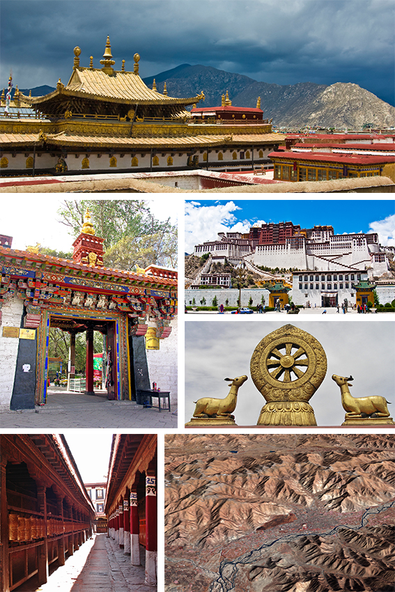
The prefecture-level city roughly corresponds to the basin of the Lhasa River, which is the center of Tibet politically, economically and culturally. Chengguan District is also the center of Tibet in terms of transport, communications, education and religion, as well as being the most developed part of Tibet and a major tourist destination with sights such as the Potala Palace, Jokhang and Ramoche Temple.
Lhasa River basin
Lhasa prefecture-level city roughly corresponds to the basin of the Lhasa River, a major tributary of the Yarlung Tsangpo. Exceptions are the north of Damxung County, which crosses the watershed of the Nyenchen Tanglha Mountains and includes part of the Namtso lake, and Nyêmo County, which covers the basin of the Nimu Maqu River, a direct tributary of the Yarlung Tsangpo.
The river basin is separated from the Yarlung Tsangpo valley to the south by the Goikarla Rigyu range.
The largest tributary of the Lhasa River, the Reting Tsangpo, originates in the Chenthangula Mountains in Nagqu Prefecture at an elevation of about 5,500 metres (18,000 ft), and flows southwest into Lhasa past Reting Monastery.
The Lhasa River drains an area of 32,471 square kilometres (12,537 sq mi), and is the largest tributary of the middle section of the Yarlung Tsangpo.
The average altitude of the basin is around 4,500 metres (14,800 ft).
The basin has complex geology and is tectonically active. Earthquakes are common.
Annual runoff is 10,550,000,000 cubic metres (3.73×10¹¹ cu ft).
Geology
The former Lhasa prefecture lies in the Lhasa terrane, to which it gives its name. This is thought to be the last crustal block to accrete to the Eurasian plate before the collision with the Indian plate in the Cenozoic.
The terrane is separated from the Himalayas to the south by the Yarlung-Tsangpo suture, and from the Qiangtang terrane to the north by the Bangong-Nujiang suture.
The Lhasa terrane consisted of two blocks before the Mesozoic, the North Lhasa Block and the South Lhasa Block.
These blocks were joined in the Late Paleozoic.
The Lhasa terrane moved northward and collided with the Qiangtang terrane along the Bangong suture.
The collision began towards the end of the late Jurassic (c. 163–145 Ma), and collision activity continued until the early Late Cretaceous (c. 100–66 Ma).
During this period the terrane may have been shortened by at least 180 kilometres (110 mi).
The collision caused a peripheral foreland basin to form in the north part of the Lhasa terrane.
In some parts of the foreland basin the north-dipping subduction of the Neotethyan oceanic crust below the Lhasa terrane caused volcanism.
The Gangdese batholith was formed as this subduction continued along the southern margin of the Lhasa terrane.
The Gangdese intrudes the southern half of the Lhasa terrain.
Contact with India began along the Yarlung-Zangbo suture around 50 Ma during the Eocene, and the two continents continue to converge.
Magmatism continued in the Gangdese arc until as late as 40 Ma.
There was significant crustal shortening as the collision progressed.
The South Lhasa terrane experienced metamorphism and magmatism in the Early Cenozoic (55–45 Ma) and metamorphism in the Late Eocene (40–30 Ma), presumably due to the collision between the continents of India and Eurasia.
Rocks in this region include sedimentary rocks from the Paleozoic and Mesozoic into which granite has intruded during the Cretaceous.
Climate

The Lhasa valley is roughly the same latitude as the southern United States, but at an altitude of 3,610 metres (11,840 ft) or more it is cooler.
The central river valleys of Tibet are warm in summer, and even in the coldest months of winter the temperature is above freezing on sunny days.
The climate is semi-arid monsoon, with a low average temperature of 1.2 to 7.5 °C (34.2 to 45.5 °F).
Average annual precipitation is 466.3 millimetres (18.36 in), with 85% falling in the June–September period.
Typically, there are 3,000 hours of sunshine each year.
It is cooler in the northern regions, warmer in the south. Annual figures:
Studies of temperature and precipitation data from 1979 to 2005 indicate that higher temperatures are leading to longer snow-free periods at the lower elevations.
However, at higher levels the amount of precipitation has increased, so despite warming the snow-free period is shorter.
Environment

Most of the population of Tibet lives in the southern valleys, including those around Lhasa.
The higher regions are used by nomadic drokpa who tend herds of yaks, sheep and goats on the steppe grasslands of the hills and high valleys.
In the lower parts it is possible to cultivate products that include barley, wheat, black peas, beans, mustard, hemp, potatoes, cabbage, cauliflower, onions, garlic, celery and tomatoes. The traditional staple food is barley flour called tsampa, often combined with buttered tea and made into a paste.
A visitor described the valley around Lhasa in 1889 as follows,
The plain over which we are riding is a wonderfully fruitful one. It is skirted on the south by the Kyi river, and is watered, moreover, by another smaller stream from the north, which flows into the Kyi ... some five miles west of Lhasa. All this land is carefully irrigated by means of dikes and cross-channels from both rivers. Fields of buckwheat, barley, pea, rape, and lindseed lie in orderly series everywhere. The meadows near the water display the richest emerald-green pasturage. Groves of poplar and willow, in shapely clumps, combine with the grassy stretches to give in places a parklike appearance to the scene. Several hamlets and villages, such as Cheri, Daru, and Shing Dongkhar, are dotted over these lands. A fertile plain truly for a besieging army!
The Lhasa region does not have abundant wildlife or great numbers of species, but the Lhasa valley does support wintering populations of hundreds of black-necked cranes.
Hutoushan Reservoir lies in Qangka Township, Lhünzhub County.
The reservoir is bordered by large swamps and wet meadows, and has abundant plants and shellfish.
The reservoir, which lies in the Pengbo valley, is the largest in Tibet, with total storage of 12,000,000 cubic metres (420,000,000 cu ft).
Administrative divisions

Lhasa prefecture-level city consists of three districts and five counties.
Chengguan District, Doilungdêqên District, and Dagzê District contains most of the urban area of Lhasa, which lies in the Lhasa River valley floor.
Chengguan District
Chengguan District is located on the middle reaches of the Lhasa River, with land that rises to the north and south of the river.
It is 28 kilometres (17 mi) from east to west and 31 kilometres (19 mi) from north to south.
Chengguan District is bordered by Doilungdêqên District to the west, Dagzê District to the east and Lhünzhub County to the north.
Gonggar County of Lhoka (Shannan) City lies to the south.
Chengguan District has an elevation of 3,650 metres (11,980 ft) and covers 525 square kilometres (203 sq mi).
The urban built-up area covers 60 square kilometres (23 sq mi). The average annual temperature is 8 °C (46 °F).
Annual precipitation is about 500 millimetres (20 in), mostly falling between July and September.
Before the PRC takeover the city of Lhasa had a population of 25,000–30,000, or 45,000–50,000 if the large monasteries around the city are included.
The old city formed a quadrangle about 3 square kilometres (1.2 sq mi) around the Jokhang temple, about 1 kilometre (0.62 mi) to the east of the Potala Palace.
During the period before the reforms introduced by Deng Xiaoping the old city of Lhasa was left largely intact, while bleakly functional compounds containing symmetrical dormitory-type buildings for both living and working were built apart from the city along the main roads.
By 1990 the city had expanded to cover 40 square kilometres (15 sq mi), with an official population of 160,000.
The 2000 official census gave a total population of 223,001, of which 171,719 lived in the areas administered by sub-districts and residential committees.
133,603 had urban registrations and 86,395 had rural registrations, based on their place of origin.
Demographics

The demographics of Lhasa prefecture-level city are difficult to define precisely due to the way in which administrative boundaries have been drawn, and the way in which statistics are collected.
According to the 2020 census, population of Lhasa prefectural-level city is about 867,891, of whom about 16.9% are ethnic Han and most of the others are ethnic Tibetans. A large part live in the city and in towns, most of them in or near Chengguan District, and the remainder live in rural areas.
Ethnicity
The 2000 census give the following breakdown for the population of the prefecture-level city as a whole:
The 2000 census counts more than 105,000 people in Chengguan District who are registered elsewhere.
Most of them are Han, with agricultural registrations.
Outside Chengguan District, in 2000 the rural townships almost all had Han populations below 2.85%, other than one in Duilongdeqing County and one in Qushui County, both near the metropolitan district of Lhasa. Urban towns other than Yangbajain had Han populations of between 2.86% and 11.25%. Within the metropolitan district Han population ranged from 11.26% to 11.25% in the southern rural township to 46.56% to 47.46% in the city street offices.
Han migrants accounted for 20% of the population, but held a much higher percentage of the higher-status office and service-sector jobs.
Hans also dominated construction, mining and trade.
According to the November 2000 census, the ethnic distribution in Lhasa Prefecture-level City was as follows:
Administrative divisions
Lhasa metropolitan district includes most of the built-up area, which counts as urban, and four rural townships.
The counties also contain urban towns, of which there are nine in the prefectural municipality.
The census figures differ considerably from the Tibet Statistical Yearbooks for the same period, since the yearbook only includes the registered population and counts them based on place of origin rather than place of residence. The 1990 census used an approach similar to the yearbook, so the numbers are misleading, but the 2000 census tried to count people who had actually been present in Lhasa for over six months. The census distinguishes between "agricultural" and "non-agricultural" registration, but this does not reflect the actual occupations of the people. Many with an "agricultural" registration may in fact work in the city or in a town.
Education
Lhasa has two universities, Tibet University and Tibet Tibetan Medical University. Additionally, there are three special colleges: Lhasa Teachers College, Tibet Police College and Tibet Vocational and Technical College.
Tibet University (Tibetan: བོད་ལྗོངས་སློབ་གྲྭ་ཆེན་མོ་) is the main university of Tibet Autonomous Region. Its campus is located in Chengguan District, Lhasa, east of the city-centre. A forerunner was created in 1952 and the university was officially established in 1985, funded by the Chinese government. About 8000 students are enrolled at the university. Tibet University is a comprehensive university with the highest academic level in Tibet Autonomous Region. It is a member of the prestigious Project 211, and is sponsored under the Double First Class Disciplines initiative.
Infrastructure

Highways
China National Highway 318 enters the prefecture-level city from the east at Mila Mountain, where it reaches an elevation of 5,000 metres (16,404 ft).
The highway runs through Maizhokunggar County from east to west.
It continues along the south bank of the Lhasa River through Dagzê County, then crosses to the north of the river in Chengguan District and runs through the center of the urban district. It turns south to cross Doilungdêqên District, where it is joined by 109, and continues down the west side of the Lhasa River through Qüxü County, and then along the north shore of the Yarlung Tsangpo through Nyêmo County, and onward to the west.
China National Highway 109 (the Qinghai–Tibet Highway) runs through Damxung County from the northeast to southwest, then turns to the southeast at Yangbajain.
It then runs through Doilungdêqên District along the Duilong River valley, to join China National Highway 318 just west of Lhasa.
The Lhasa Airport Expressway from Lhasa to Lhasa Gonggar Airport in Lhoka (Shannan) Prefecture is the first expressway in the Tibet Autonomous Region.
Construction began in April, 2009. The expressway is 37.8 kilometres (23.5 mi) long and has four lanes.
Railway
The Qinghai–Tibet Railway runs through the Lhasa prefecture-level city beside the Qinghai–Tibet Highway through Damxung County and Doilungdêqên District.
It terminates at Lhasa railway station in Niu New Area (Liuwu Township).
The terminus of the Qinghai–Tibet line, this station is over 3,600 metres (11,800 ft) above sea level, and is its largest passenger transport station.
It includes a clinic with oxygen treatment facilities. The station uses solar energy for heating.
The Liuwu Bridge links central Lhasa to Lhasa railway station and the newly developed Niu New Area of Doilungdêqên District on the south bank of the Lhasa River. Residents in the area were resettled to make way for the new development.
Temples and monasteries

Buddhism was adopted as the official religion of Tibet by king Songtsän Gampo (died 649) at a time when the rise of Hinduism was sweeping away Buddhism in India, the land of its birth. Over the next two centuries Buddhism became established in Tibet, now the center of the religion.
Tibetan Buddhism would become a pervasive influence on the lives of the people.
The first monastery, Samyé, was founded by Trisong Detsen (c. 740–798).
Its buildings were arranged in a mandala pattern after the Odantapuri monastery in Bihar. The three-story monastery was completed in 766 and consecrated in 767.
Seven Tibetans took monastic vows in a ceremony that marked the start of the long Tibetan tradition of monastic Buddhism.
Early foundations
Yerpa, on a hillside in Dagze County, is known for its meditation cave connected with Songtsän Gampo.
The cliffs contain some of the earliest known meditation sites in Tibet, some dating back to pre-Buddhist times. There are a number of small temples, shrines and hermitages.
Songtsän Gampo's queen, Monza Triucham, founded the Dra Yerpa temple here.
Jokhang in Chengguan District is the most sacred temple in Tibet, built in the 7th century when Songtsän Gampo transferred his capital to Lhasa.
It was designed to house an image of Buddha that the Nepalese queen Tritsun had brought. Later rulers and Dalai Lamas enlarged and elaborated the temple.
Ramoche Temple to the north of Jokhang is considered the most important temple in Lhasa after Jokhang, and was completed about the same time.
Muru Nyingba Monastery is a small monastery located between the larger Jokhang temple and Barkhor in the city of Lhasa.
It was the Lhasa seat of the former State Oracle who had his main residence at Nechung Monastery.
It was destroyed during the persecution of Buddhism under Langdarma (c. 838–841) but rebuilt by Atiśa (980–1054).
Kaynak: Wikipedia – Lhasa (prefecture-level city) · CC BY-SA 4.0
Coğrafya

Lhasa ülkenin güneydoğusunda, Himalaya Dağları'nın yüksek tepelerinden birinin üzerindeki bir düzlükte denizden 3.600 metre yüksekte kurulmuştur. Şehir, doğuda Nyingchi ile batıda Xigazê il düzeyi şehirleri, kuzeyde Nagqu ile güneyde Shannan illeri ile komşudur. Ayrıca Hindistan sınırına çok yakındır.
Mimari
Lhasa'da tarihi önem taşıyan birçok bina vardır. Başlıcaları 652 yılında yaptırılmış olan Jokhang Tapınağı ve şehrin kuzeyindeki Ramo-çe Tapınağı'dır.
Lhasa'daki binaların çoğu taş ve tuğladan yapılmıştır. Evler genel olarak iki ya da üç katlıdır, bacasız ve alçak çatıları vardır.
Ulaşım
Lhasa, Qinghai-Tibet Demiryolu üzerinde yer almaktadır. Şehre hizmet veren Lhasa Gonggar Havalimanı ise Shannan ilinde bulunmaktadır.
Kaynak: Wikipedia – Lhasa · CC BY-SA 4.0