

Overview
恵庭市(えにわし)は、北海道西部に位置し、石狩振興局に属する市。
Interested in working with us in the future?
Follow to see new jobs and posts in your feed.
No news yet.
About

恵庭市(えにわし)は、北海道西部に位置し、石狩振興局に属する市。
Kaynak: Wikipedia · CC BY-SA 4.0
概要
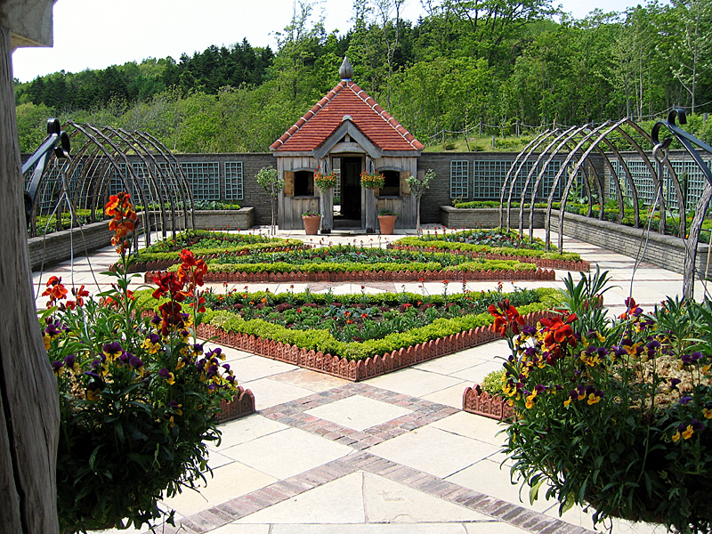
恵庭市は札幌市と新千歳空港のほぼ中間に位置しており、恵まれた交通アクセスと穏やかな気候風土を持つまちになっている。市民主導による花のまちづくりが盛んで全国的に評価され、これまでに『緑化推進運動功労者』内閣総理大臣表彰(平成7年「花いっぱい文化協会」、平成13年「サッポロビール北海道工場」)、『都市景観大賞』「美しいまちなみ大賞」国土交通大臣表彰(平成16年「恵み野地区」)、『花の観光地づくり大賞』(平成22年「恵庭市」)などを受賞しており、「ガーデニングのまち」として知られるようになった。
地名の由来
アイヌ語で現在の恵庭岳を指す「エエンイワ」(頭が・尖っている・山)に由来するとされている。
地理

市域は東西約34 km、南北約23 km、総面積294.87 km²であり、自衛隊の演習地も含めると市域の約3分の2が森林地帯になっている。山岳部は「支笏洞爺国立公園」になっており、恵庭岳、漁岳、空沼岳を源とする漁川やラルマナイ川、千歳川へ合流する島松川などの河川がある。
地域
戸磯、恵南、和光町、駒場町、白樺町、黄金北、黄金中央、黄金南、相生町、緑町、住吉町、末広町、栄恵町、泉町、桜町、京町、漁町、福住町、新町、本町、有明町、大町、文京町、牧場、盤尻、桜森、中島町、恵央町、幸町、柏陽町、柏木町、北柏木町、島松沢、美咲野
島松寿町、島松仲町、島松東町、島松本町、島松旭町、西島松、南島松の一部、中島松、下島松、穂栄、北島
地名の変遷
大字漁村・大字島松村の2大字で構成された恵庭町では1960年から2年にわたり大字小字を廃止し新たに町名を設定した。その内容は以下の通りである。
人口
恵庭市の人口は、札幌市の近郊都市として1970年(市制施行)から2012年まで増加の一途を辿ってきたが、2013年に初めて人口減少となった。
消滅集落
2015年国勢調査によれば、以下の集落は調査時点で人口0人の消滅集落となっている。
気候
ケッペンの気候区分では、恵庭市は湿潤大陸性気候・亜寒帯湿潤気候(Dfb)に属する。恵庭市全域が豪雪地帯に指定されている。
年平均気温は7.2℃である。平年値では猛暑日が0.0日、真夏日が3.7日、夏日が36.4日、熱帯夜が0.0日、真冬日が56.3日、冬日が159.3日となっている。また、12月から3月にかけて日平均気温が氷点下となっている。
冬季は、近年でも-25℃付近の気温が観測され、2023年1月30日に-24.8℃を観測している。
歴史
恵庭の開拓は1870年(明治3年)に高知藩が移住したことによって始まり、1886年(明治19年)に山口県岩国・和木地方から集団移住65戸が漁川沿いに入植して本格的な開拓が始まった。
沿革
1755年(宝暦05年):武川久兵衛(飛騨屋)が松前藩の許可を受けて漁川流域を伐採。
1869年(明治02年):蝦夷地を北海道と改称して11国86郡が置かれ、胆振国千歳郡となる。
1873年(明治06年):中山久蔵が島松で水稲(赤毛種)の栽培に成功。札幌—室蘭間道路(札幌本道)開通し、島松沢に駅逓所(旧島松駅逓所)設置。
1886年(明治19年):北海道庁設置により、千歳郡が石狩国に移管。山口県岩国・和木地方から団体移民が漁川沿岸に入植。
1893年(明治26年):加越能開耕社移民として、石川県と富山県から100戸余が入植。
1897年(明治30年):漁村・島松村が千歳郡戸長役場から分離独立し、漁村外一ヶ村戸長役場設置。
1906年(明治39年):漁村と島松村を合わせて恵庭村とし、北海道二級町村制施行。
1926年(大正15年):北海道鉄道札幌線(現在の千歳線)開通(島松駅、恵庭駅開業)。
1932年(昭和07年):恵庭鉱山試掘開始(1939年本格操業。1943年休山)。
1936年(昭和11年):村内で陸軍特別大演習が行われた。島松野外統監部が設けられ昭和天皇が行幸。
1943年(昭和18年):柏木に陸軍北部教育隊設置。同年10月1日、大字島松村の一部を広島村へ編入(現在の東の里地区)。
1950年(昭和25年):旧教育隊跡に警察予備隊設置(陸上自衛隊北恵庭駐屯地の前身)。
1952年(昭和27年):保安隊(後の陸上自衛隊)北海道地区補給処設置(現在の陸上自衛隊北海道補給処)。南恵庭駐屯地設置。
1970年(昭和45年):市制施行し、恵庭市となる。市民憲章制定。同時に千歳郡が消滅する。
1971年(昭和46年):道央自動車道(道央道)初の供用区間となる北広島IC—千歳IC間開通(恵庭IC供用開始)。
1982年(昭和57年):恵み野駅開業。イトーヨーカドー恵庭店開店(2019年閉店)。
1989年(平成元年):「道央テクノポリス地域」(テクノポリス)指定。恵庭RBパークセンタービル完成。サッポロビール北海道工場完成。
1999年(平成11年):北海道文教大学開学。北海道道117号恵庭岳公園線全線開通。道東自動車道千歳恵庭JCT—夕張IC間開通。
2006年(平成18年):コミュニティ放送「FMパンプキン」(「e-niwa(いーにわ)」の前身)放送開始。えこりん村オープン。道と川の駅花ロードえにわオープン。
2015年(平成27年):恵庭駅西口再開発ビル「いざりえ」、JR恵庭駅連絡通路(空中歩廊)完成。フレスポ恵み野オープン。
政治
役所
島松支所:1958年(昭和33年)に恵庭町公民館島松分館が島松支所の所在する現在地に新築されたのを機に、島松駅寄りにあった出張所を島松分館と併設。その後、1984年(昭和59年)に住民の集会施設である島松市民センターと併設し島松出張所が完成。翌、1985年(昭和60年)に支所に昇格。
恵み野出張所:1979年(昭和54年)から開発が進められた恵み野住宅団地の発展に伴い、地域住民の利便性と市民サービスの向上を図るため、1987年(昭和62年)4月1日に恵み野会館内に開設。その後、恵み野の街も着実に発展し利用者が多くなり事務所が狭隘化してきたことから2000年(平成12年)4月1日より現在のRBPパークセンタービル内1階に移設。
中恵庭出張所:1906年(明治39年)に漁村と島松村が北海道二級町村制の施行により「恵庭村」として誕生したが、役場の建設場所を巡り両村で綱引きとなり、間をとって「中恵庭」地区に役場が設置された。その後、役場は1910年(明治43年)・1926年(大正15年)に改築され、1952年(昭和27年)町制が施行されたのを機に市役所本庁がある現在地に移転され、恵庭市消防団第三分団の車庫、詰所を併設した建物となった。
経済

農業
農業は明治初期から本格的に始まっている。恵庭は中山久蔵が北海道での米作りに成功した地であり、現在も米の産地になっている。
また、特別栽培農産物などの安心安全でクリーンな農業をテーマにした野菜づくりや花苗生産などの近郊農業が盛んになっている。
畜産業
酪農では優良牛生産地帯であり、家畜の糞尿を堆肥化して活用する循環型環境整備を進めている。
工業
工業では7か所の工業団地(恵庭市工業団地など)があり、約230社が操業している。札幌市や新千歳空港、苫小牧港などへの交通アクセスが良いほか、支笏湖の伏流水が湧き出るなど豊かな水資源があり、企業進出の一因になっている。市内には研究開発拠点の「恵庭リサーチ・ビジネスパーク」がある。
商業
商業では商店街がイメージアップや魅力向上に繋がる事業を助成する集客支援、起業支援等を行っている。また、国道36号恵庭バイパス沿いを中心にロードサイド店舗が進出している。
文化・名物
名産・特産
恵庭の特産品として「えびすかぼちゃ」(カボチャ)がある。1964年(昭和39年)に京都の種苗会社が開発したえびすかぼちゃを北海道内でいち早く栽培したのが恵庭であり、「恵庭のえびす」として関西地方を中心に流通していた。2006年(平成18年)の道の駅花ロードえにわオープン後は地元でも購入して食すようになり、スイーツなどの商品開発に取り組んでいる。また、恵庭でも収穫できるようになったサツマイモを使用したスイーツもある。
恵庭は北海道内有数の花苗の産地であり、生産量、品質、種類のどれをとってもトップクラスになっている。札幌市の大通公園にある花壇の大半は恵庭産の花を使用している。
恵庭市を舞台とした作品
番組
バラエティ番組『タカトシ牧場』は、恵庭市の「むらかみ牧場」で酪農や農業を行うなど、主なロケ地としていた。
参考資料
“恵庭市制施行40周年記念誌「EKUBO」” (PDF). 恵庭市 (2010年). 2017年4月13日閲覧。
外部リンク
Garden city Eniwa(ガーデンシティえにわ) (@eniwa_garden_city) - Instagram
Eniwa Eye(北海道恵庭市) (157626288189433) - Facebook
ENIWA EYE(北海道恵庭市観光) (@eniwa_eye) - Instagram
一般社団法人 恵庭観光協会(北海道恵庭市) (eniwa.org) - Facebook
Kaynak: Wikipedia – 恵庭市 · CC BY-SA 4.0
Kardeş şehirler
Eniwa'nın aşağıdaki şehirler ile kardeş şehir anlaşması bulunmaktadır.
Kaynak: Wikipedia – Eniwa · CC BY-SA 4.0
Etymology
The town's name is taken from the nearby Mount Eniwa, in the Shikotsu-Tōya National Park. The name in Ainu, e-en-iwa (エエンイワ), means "sharp mountain." The name was transliterated into Japanese ateji to mean blessed garden. The Japanese transliteration was chosen because of the homonyms niwa (庭; "garden") and niwa (二輪; "two rings"), the later referring to the two rivers that pass through the city, the Shimamatsu River and the Izari River, as well as the "blessings" (恵, e) between the two rivers.
History

The first known settlement of Eniwa was in the Initial Jōmon period in 7000 BC, at the Karinba ruins (Karinba Iseki). The settlement received a surge of people in 2000 B, and continued being settled for many years. Many artifacts have been found, including lacquered combs, beads, earthenware and stone accessories. Historical Satsumon culture (700–1200 CE) graves dating have been found around Eniwa, at the Moizari Kofun Site (茂漁古墳群, Moizari kofun-gun). The style is similar to those at the Ebetsu Kofun Site and northern Tōhoku historic graves. During the Ainu settlement period (1200 CE until the Meiji era), there is historical evidence for settlements in the villages and further away on the plains.
After the Matsumae clan settled on the southern tip of Hokkaido in 1590, they traded goods with the Ainu who lived in the area. In the Edo period, one of the 13 trading locations across the Ishikari plain was Shuma-mappu Location (シュママップ場所, Shumamappu Basho) (Ainu: Shuma-o-mappu (シュマ・オ・マップ)), which corresponds to the modern-day Shimamatsu River basin. The trading area was active until the end of the Edo era. Early Japanese contact with the area included in 1755, when jezo spruce trees were harvested along the Izari river, and in 1805, when the river was farmed for salmon and trout.
In 1857, the Hakodate magistrate decreed that a road between Otaru and Chitose be developed, leading to the development of the Ishikari Plain. When Hokkaido became a part of Japan in the early Meiji period, the area around Eniwa was incorporated into Iburi Province in 1869.
Settlers from Kōchi Prefecture initially settled in Eniwa in 1870 in two villages: Izari Village (漁村, Izari-mura) in the south and Shimamatsu Village (島松村, Shimamatsu-mura) in the north. In 1873, the Sapporo Highway (札幌本道, Sapporo Hondō), the a road linking Hakodate with Sapporo was completed, and it was built through both villages. In 1873, rice farming started in Shimamatsu, as well as the first postal service.
Demographics
As of July 31, 2023, the city had an estimated population of 70,278 residents, with 31,005 households and the density of 239 persons per km2. 51% of the population is female. Eniwa's population is 99.7% Japanese, with the remaining 0.3% being foreign residents. 13.8% of residents are under 15 years of age, and the workforce comprises 64.4% of residents. 21.8% of people are over age 65. In the 2012 population records, 22 residents are listed as centenarians.
The bulk of the population, 68%, lives in central Eniwa, while 17.5% live in Megumino and 13.2% live in Shimamatsu. The remainder 1.3% of Eniwa residents live in the surrounding farmland.
Geography

Eniwa is on the Ishikari Plain, amongst farmland. The town is 8 km from Chitose (and the New Chitose Airport), and to the north is Kitahiroshima City. 26 km north of Eniwa is Sapporo, the largest city and prefectural capital of Hokkaido. All of these cities are connected by the Chitose Line railway and by the Japan National Route 36. The town is on the Izari River and the Shimamatsu River.
The area administered to by Eniwa extends north to the Shimamatsu river and stops at the border to Naganuma township in Sorachi Subprefecture. Eniwa borders Chitose city along its south border, with the cities being separated by as little as 750 m in some places. To the west of Eniwa is the Shikotsu-Tōya National Park. Eight mountains in the park are considered a part of Eniwa, including Mount Izari and Mount Soranuma. In the area is the hydroelectric Izarigawa Dam that dams the Izari river.
The city of Eniwa is separated into three major areas: Eniwa in the south, Megumino (恵み野) in the center and Shimamatsu in the north. Shimamatsu is separated from Eniwa and Megumino by approximately 300 meters.
climate
Winters in Eniwa are colder than the surrounding areas, due to the town being inland. The average daily low temperature is between 5-6 degrees lower than Sapporo, 26 km to the north near the Sea of Japan, and 4-5 degrees lower than in Tomakomai, 28 km to the south on the coast of the Pacific Ocean. Summers are slightly milder than in Sapporo.
Economy

Traditionally, Eniwa's economy was based around farming, with the first major rice farms created in 1873. Eniwa has two main crops: flowers and rice. 3,800ha of land are dedicated to flowers, most of which are cut flowers. 2,700 ha of land are dedicated to rice farming, mostly ley farming, though paddy field rice exists. Rice in Eniwa is generally made up of the Yume Pirika, Nanatsu Boshi, Oborozuki and Fukkurinko.
Eniwa also grows many vegetables. Vegetables with 100 ha or more dedicated space include wheat, soybeans, sugar beet, potatoes and daikon (Japanese radish). Other farmed vegetables include ebisu kabocha pumpkins, carrots, adzuki beans and cabbages. The ebisu kabocha is the city vegetable. Pumpkin-flavored soft serve, manjū and soup can be bought at the Flower Road Eniwa roadside station.
In the Heisei era, manufacturing has increasingly become an important industry. In 1989, an area in southern Eniwa became dedicated to manufacture, called the Eniwa Techno Park (恵庭テクノパーク, Eniwa Tekuno Pāku). In the same year, the Sapporo Brewery Hokkaido factory was built. It deals with 120 million liters of beer per year. There are many food production factories are in Eniwa, including ones for Sanmaruko, the restaurant chain Tonden, oden producer Horikawa, Hoshio Milk, Yamazaki Baking, Kibun Foods and Robapan. Morinaga Milk Industry built its Sapporo Factory in Eniwa in 1961; in April 2013 it halted all manufacturing there, leaving the site as a delivery depot.
There are mechanical factories for Sanwa Holdings, MSK Farm Machinery, Mitsubishi's customized machinery division and Oji Paper.
Three camps for the Japan Ground Self-Defense Force's Northern Army are in Eniwa — Camp Shimamatsu, Camp Kita Eniwa, and Camp Minami Eniwa — where the Northern Army performs military exercises, including the 1st Tank Group's tank practice.
Religion

There are a variety of Buddhist temples, Shinto shrines and Christian churches in Eniwa. Most of the institutions were established in the Meiji period. The most recent Shinto shrine was built in 1908.
There are seven Buddhist temples in Eniwa. The largest is Ten'yū-ji, an Otani-ha temple established in 1886. Daian-ji was initially established as a terakoya school for the children of Eniwa in 1887, but grew to be a temple in 1911. The Eniwa Buddhist temples follow a variety of schools. Two of the temples are Otani-ha, two are Hongan-ji, Kōryū-ji is a Kompira worshiping Kōyasan Shingon-shū temple, Daian-ji is Sōtō and Myōshō-ji is Nichiren Shū.
There are four Shinto shrines around Eniwa. Toyosaka Shrine was first established in 1874 as an area dedicated to Inari Ōkami, with a small shrine for Ōkuninushi built at the site in 1891. A second shrine, built to accommodate settlers from Toyama and Ishikawa. Shimamatsu Shrine was established in 1901 from donations from the people who lived in Shimamatsu. The fourth, Kashiwagi Shrine, was established in 1908. Much of the shrine was demolished in 1982 due to dilapidation. In Eniwa, there are six Shinto gods who have been enshrined: Toyouke-Ōmikami (at Toyosaka and Shimamatsu), Ōkuninushi (at Toyosaka), Amenominakanushi (at Kashiwagi) and Amaterasu, Inari Ōkami and Kasuga Ōkami at Eniwa Shrine.
There are three Christian churches in Eniwa, the Catholic Eniwa Parish, Eniwa Evangelical Christian Church and the Eniwa Evangelical Lutheran church. In addition, there is a Jehovah's Witness church, as well as a church for the Chitose and Eniwa ward of the Church of Jesus Christ of Latter-day Saints.
Parks and recreation

Eniwa has five public parks: Eniwa Park, Nakajima Park, Furusato Park, Megumino Central Park and Technopark Central Park. The parks are mostly around central and southern Eniwa. The largest, Eniwa Park, is 411,000 m2. In addition, the land around the banks of the Izari River is considered urban open space. Parks in Eniwa mostly consist of open spaces and woodland, though several feature sporting facilities, such as Nakajima Park's jogging track.
In 2006, an agricultural theme park called Ecorin Village was built in Eniwa. At the gardening center of the theme park is a greenhouse housing Tomato no Mori (とまとの森; "Tomato Forest"), which in November 2013 was awarded the Guinness World Records award for the largest tomato plant in the world, measuring 85.46m2 at the time.
Within the urban borders of Eniwa are several park golf grounds, a sport created in Hokkaido. Outside of the city, the Eniwa Country Club features three nine-hole golf courses.
In the Shikotsu-Tōya National Park to the west, many of the mountains such as Mount Izari and Mount Soranuma feature walking trails to their summits. The man-made Lake Eniwa (えにわ湖, Eniwa-ko) lake is behind the Izari Dam in the national park.
Education

Eniwa has two public high schools, five junior high schools, and eight elementary schools. In 2012, the city had 3,935 students enrolled at elementary schools and 2,079 at junior high schools. In 2008, 300 students were enrolled at Eniwa North High School and 200 at Eniwa South High School.
Eniwa's first school was opened in 1887, when Buddhist priest Kyūzō Nakayama established a terakoya for the children of Eniwa. In 1897, the temple school was moved and became a public school, Eniwa Elementary School. Three more elementary schools were opened in the Meiji period. By the early 1940s, Eniwa had eight elementary schools. In 1947, four new junior high schools were created, later amalgamating into two by 1964. The two high schools were opened in 1951. In the 1960s and 1970s, five elementary schools and one junior high school were closed or merged. With the building of Megumino in the late 1970s and increasing growth in the city, three new junior high schools and six new elementary schools were built between 1970 and 1991.
Eniwa has one university and three vocational schools. Hokkaido Bunkyo University's main campus is in Eniwa. The university has two departments, foreign languages and health sciences. The three vocational schools are in Megumino. The largest, the Hokkaido High-Technology College, is a multi-discipline school, with four faculties: technology, medicine, education and recovery/sports science. The Hokkaido Eco Communication College is a veterinary school, and the Nihon Fukushi Rehabilitation Gakuin is a physical medicine and rehabilitation school. In addition to these, Kinki University has its Hokkaido seminar house for natural resource research in Eniwa.
Transportation
Eniwa is connected to the Hokkaido Railway network on the Chitose Line. There are four train stations (from north to south): Shimamatsu Station, Megumino Station and Eniwa Station, as well as the remotely controlled Sapporo Beer Teien Station. The Eniwa Station is a designated stop for Rapid Airport trains, though not a stop for limited express trains such as the Super Ōzora or the Super Tokachi.
Japan National Route 36 and Japan National Route 453 run through Eniwa. There are two toll express roads through Eniwa, the Hokkaidō Expressway and the Dōtō Expressway which begins at the Chitose-Eniwa junction. There are two bus services in Eniwa. The Hokkaido Chuo Bus transports passengers around Hokkaido and passes through Eniwa. The Eniwa Community Bus was established in 2004 and circuits around Eniwa.
Eniwa is serviced by the New Chitose Airport for air travel, 15 km away. It is an international airport, with destinations mainly in Asia such as Seoul, Shanghai and Taipei. However, the bulk of its traffic is Japanese domestic travelers.
Community work
In the spring and summer, community organisations plant flowers around the city's public gardens, leading to the moniker 'Gardening Town' (ガーデニングのまち, gādeningu no machi).
Mascots
Eniwa's mascots are Ebisu-kun (えびすくん), Karin-chan (かりんちゃん) and Eniwan (えにわん).
Ebisu-kun is an oni that is born from a Kabocha pumpkin. He promotes and protects products from the city. He works as a mascot for the Eniwa Chamber of Commerce and lives in a room of the local conference hall.
Karin-chan is a yōsei born from a lily of the valley. She protects nature.
Eniwan is a dog who is a flower enthusiast (as such, she wears a flower as a hat). She helps people who migrate to the city like Chiwawa (ちわわん) (who moved from the Southern Hemisphere in September 2013), Papawan (ぱぱわん), Mamawan (ままわん) and Juniwan (じゅにわん) (the latter three are a family who moved from the Western world). Her name not only comes from "anyone" but is also a play on the city's name. Her name fits because she welcomes every being around the world to Eniwa.
Kaynak: Wikipedia – Eniwa, Hokkaido · CC BY-SA 4.0