

Overview
渋川市(しぶかわし)は、群馬県のほぼ中央、関東平野の最北西端に位置する市。東京都心から、およそ120 kmの距離にある。
Interested in working with us in the future?
Follow to see new jobs and posts in your feed.
No news yet.
About

渋川市(しぶかわし)は、群馬県のほぼ中央、関東平野の最北西端に位置する市。東京都心から、およそ120 kmの距離にある。
Kaynak: Wikipedia · CC BY-SA 4.0
地理
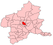
西にそびえる榛名山の裾野にあり、東に赤城山を望み、北には子持山と小野子山がそびえる。北から利根川、西から吾妻川が流れ市内白井で合流する。
歴史
高崎から金古を経由する三国街道の宿場町で、加えて本庄から総社を経由する佐渡奉行街道が合流する交通の要衝として栄えた。1613年(慶長18年)に町割が始まったとされ、上ノ町・中ノ町・下ノ町の3町に問屋が置かれた。本陣・脇本陣は置かれなかったが、江戸時代後期には越後の諸大名や佐渡奉行が宿泊している。
六斎市が開かれる市場町でもあり、上ノ町で2日と17日、中ノ町で7日と22日、下ノ町で12日と27日に開かれていた。初市は1630年(寛永7年)。
沿革
1889年(明治22年)4月1日 - 町村制施行により、西群馬郡に渋川町・金島村・古巻村・豊秋村が誕生。
1954年(昭和29年)4月1日 - 北群馬郡渋川町・金島村・古巻村・豊秋村の1町3村の合併により(旧)渋川市が発足。
2006年(平成18年)2月20日 - (旧)渋川市と北群馬郡伊香保町・小野上村・子持村、勢多郡赤城村・北橘村の新設合併により、現在の渋川市となった。
合併後の住所表記
旧・渋川市は大字なしの地区(市制施行以前の旧渋川町域)が「渋川」となった。それ以外の地区は変更なし。(それまでの渋川地区では小字毎に郵便番号が振られていたが、これを機に「渋川」で統一された。)
旧伊香保町、旧赤城村と旧北橘村は渋川市の後に「伊香保町」、「赤城町」、「北橘町」とそれぞれ付き、その後に大字名が付く。
地域

渋川地区
1954年(昭和29年)4月1日までの北群馬郡渋川町。2006年(平成18年)2月20日までは大字がなく、渋川市の次に番地がきていた。便宜的に小字についても掲載する。現在は前述のとおり「渋川市渋川」となっている。
金島地区
1954年(昭和29年)4月1日までの北群馬郡金島村にあたる地域であり、合併により旧渋川市となった地域。
古巻地区
1954年(昭和29年)4月1日までの北群馬郡古巻村にあたる地域であり、合併により旧渋川市となった地域。
豊秋地区
1954年(昭和29年)4月1日までの北群馬郡豊秋村にあたる地域であり、合併により旧渋川市となった地域。
伊香保地域
2006年(平成18年)2月20日までの北群馬郡伊香保町にあたる地域であり、合併により渋川市となった地域。
赤城地域
2006年(平成18年)2月20日までの勢多郡赤城村にあたる地域であり、合併により渋川市となった地域。
敷島地区
1956年(昭和31年)9月1日までの勢多郡敷島村にあたる地域であり、合併により赤城村となった地域。
横野地区
1956年(昭和31年)9月1日までの勢多郡横野村にあたる地域であり、合併により赤城村となった地域。
北橘地域
2006年(平成18年)2月20日までの勢多郡北橘村にあたる地域であり、合併により渋川市となった地域。
子持地域
2006年(平成18年)2月20日までの北群馬郡子持村にあたる地域であり、合併により渋川市となった地域。
長尾地区
1960年(昭和35年)9月1日までの北群馬郡長尾村にあたる地域であり、合併により子持村となった地域。
白郷井地区
1960年(昭和35年)9月1日までの北群馬郡白郷井村にあたる地域であり、合併により子持村となった地域。
小野上地域
2006年(平成18年)2月20日までの北群馬郡小野上村にあたる地域であり、合併により渋川市となった地域。
議会
衆議院
任期 : 2026年(令和8年)2月8日 - 2030年(令和12年)2月7日(「第51回衆議院議員総選挙」参照)
経済
産業
伊香保地区は伊香保温泉を抱え、観光業が盛ん。また、名物に水沢うどんや湯の花まんじゅうがある。
姉妹都市・提携都市
渋川市には以下の姉妹都市・友好都市がある(うち2つは旧伊香保町の提携関係を継承したものである)。固有名詞の表記は渋川市サイトに従った。
温泉地同士の交流を希望したアバノテルメ市長が友人を介して群馬県に交流先の打診を行い、伊香保町が紹介された。
19世紀後半にハワイ王国駐日公使を務めたロバート・W・アルウィンの別邸が伊香保にあった縁。1987年より伊香保とヒロ市との交流が始まる。1992年5月26日、ハワイ郡ワイアケア中学校と伊香保町立伊香保中学校(当時)の間で姉妹校協定締結。
「日本のへそ」を自認する渋川市と「イタリアのへそ」(Centro d'Italia)を自負するフォリーニョとの、「へそ」を縁とする関係。1996年、渋川青年会議所がフォリーニョ市の選手を日本のまんなか渋川駅伝に招待、1997年9月にフォリーニョ市が渋川市側をクインターナ祭に招待。以後、イタリア中部地震(1997年)復興支援、全国へそのまちサミット渋川大会へのフォリーニョ市長特別参加(1999年)などを通じ交流を深める。
1992年に渋川市からファカタネ市に中学生を派遣したのを契機として交流が深まる。
テレビアニメ『美男高校地球防衛部シリーズ』の舞台となる架空の都市で、渋川市がモチーフとなっている。架空の市と姉妹都市になる事例は全国的にも珍しいケースである。
医療・教育
社会教育
渋川市美術館・桑原巨守彫刻美術館(しぶかわしびじゅつかん・くわはらひろもりびじゅつかん)
渋川市役所第二庁舎内にある市立美術館。群馬県沼田市出身の桑原巨守の彫刻作品を常設展示している。
原美術館(東京都品川区)の分館であり、伊香保グリーン牧場内にある現代美術を展示する私立美術館。
交通
鉄道
渋川駅は市の中心部に位置するだけでなく、上越線から吾妻線の分岐する交通の要地である。伊香保温泉への入り口駅の一つでもあり、全ての昼行特急列車が停車する。
路線バス
※かつては旧北橘村の村営バスが渋川市営として引き継がれたが、こちらも日本中央バスに委託された。榛東、箕郷方面の路線はかつて群北第一交通が運営していた(現在は群馬バスに移管)。
高速バス
当市内を発着する高速バスは、渋川駅と伊香保温泉(一部路線はいずれか片方のみ)を発着している。
上州ゆめぐり号/東京ゆめぐり号(上野駅・東京駅JR高速バスターミナル・バスタ新宿〜渋川駅・伊香保温泉・中之条駅入口・草津温泉)(JRバス関東が運行)
四万温泉号(東雲車庫・東京駅八重洲通り・川越駅西口〜渋川駅・中之条駅入口・四万温泉)(関越交通が運行)
吉祥寺〜草津温泉線(吉祥寺駅北口〜渋川駅・中之条駅入口・草津温泉)(関越交通・関東バスが運行)
伊香保四万温泉号羽田線(羽田エアポートガーデン・東京駅JRバスターミナル〜渋川駅・伊香保温泉・中之条駅入口・四万温泉)(関越交通が運行)
ゆめぐり埼玉号(加須駅北口・行田市駅南口・熊谷駅南口〜伊香保温泉・草津温泉)(秩父鉄道観光バスがJRバス関東アライアンスで運行)※2024年1月20日運行開始。
ゆめぐり八王子線(京王八王子駅・JR八王子駅北口〜渋川駅・伊香保温泉・草津温泉)(群馬バスがJRバス関東アライアンスで、西東京バスと共同運行)
ゆめぐり千葉号(白子町・茂原駅・長南町・千葉駅〜渋川駅・伊香保温泉・草津温泉)(小湊鉄道がJRバス関東アライアンスで運行)※2025年12月3日運行開始
名所・旧跡・観光スポット

レジャー
臨済宗 佛光山法水寺 - 2018年4月21日に落成(建立)した台湾の仏教の宗派である臨済宗の寺院(佛光山寺)。
著名な出身者
か行
木暮武太夫 (1893年生の政治家) - 衆議院議員、参議院議員、運輸大臣、木暮旅館主
た行
角田柳作 - 日本文化研究者・教育者。コロンビア大学に「日本文化研究所」を創設。ドナルド・キーンは教え子。
渋川市を舞台とした作品
ねこむすめ道草日記 (2008年-)(作中のメインとなる舞台、渋垣市は渋川市がモデルとなっている。)
頭文字D(1995年-2013年)(劇中に登場する秋名山は榛名山がモデルである。)
美男高校地球防衛部LOVE!(2015年-)(作中の舞台である眉難市は、渋川市および伊香保温泉がモデルとなっている。)
Kaynak: Wikipedia – 渋川市 · CC BY-SA 4.0
Kardeş şehirler
Abano Terme, İtalya (23 Mart 1993'ten beri)
Logan City, Avustralya (17 Nisan 1996'dan beri)
Hawaii County, ABD (22 Ocak 1997'den beri)
Kaynak: Wikipedia – Shibukawa · CC BY-SA 4.0
Geography
Shibukawa is located at the juncture of the Tone River and Agatsuma River, in the central part of Gunma Prefecture, on the northern edge of the Kantō plains. It is about 120 kilometres (75 miles) from Tokyo. To the west is Mount Haruna, and to the east is Mount Akagi. To the north are Mount Onoko and Mount Komochi. The Tone River flows from the north (between Mount Akagi and Mount Komochi) southward through the city, while the Agatsuma River flows from the west (between Mount Onoko and Mount Haruna), merging with the Tone River near the center of the city.
Shibukawa is at a central point (36°29′ N, 139°00′ E) of the Japanese archipelago and is thus known as the Bellybutton of Japan (日本のおへそ, nihon no oheso).
Shibukawa's highest altitude is 1,565 m (5,135 ft) above sea level; its lowest point is 139 m (456 ft) above sea level. The majority of the city lies between 200 and 800 metres (656 and 2,625 feet) above sea level
Farmland covers 49.88 km2 (19.26 sq mi) (20.8% of the city), housing covers 20.31 km2 (7.84 sq mi) (8.4%), and mountains and forests cover 77.39 km2 (29.88 sq mi) (32.2%) of the city’s area. The remaining 92.84 km2 (35.85 sq mi) (38.6%) has other land uses.
Surrounding municipalities
To the south: Maebashi, Shintō, Yoshioka
To the west: Takasaki, Higashiagatsuma, Nakanojō
Climate
Shibukawa has a humid subtropical climate (Köppen Cfa) characterized by warm summers and cold winters with heavy snowfall. The average annual temperature in Shibukawa is 13.7 °C. The average annual rainfall is 1335 mm with September as the wettest month. The temperatures are highest on average in August, at around 26.1 °C, and lowest in January, at around 2.3 °C.
Demographics
Per Japanese census data, the population of Shibukawa peaked around the year 1990 and has declined since.
History
Shibukawa is located within what was formerly Kōzuke Province. During the Edo period, the area of present-day Shibukawa prospered due to its location on the Mikuni Kaidō highway connecting Takasaki with Niigata. Post stations within the borders of modern Shibukawa were Shibukawa-shuku, Kanai-shuku, Kitamoku-shuku and Yokobori-shuku.
Shibukawa town was created in Nishigunma District, Gunma Prefecture on April 1, 1889, with the creation of the modern municipalities system after the Meiji Restoration. In 1896, Nishiguma District and Kataoka District merged to form Gunma District, Gunma; however, the area containing Shibukawa was separated out in October 1949 into Kitagunma District. On April 1, 1954, Shibukawa town absorbed the villages of Furumaki, Kanashima and Toyoaki to become the city of Shibukawa.
On February 20, 2006, Shibukawa absorbed the town of Ikaho, the villages of Komochi and Onogami (all from Kitagunma District), and the villages of Akagi and Kitatachibana (both from Seta District).
Government
Shibukawa has a mayor-council form of government with a directly elected mayor and a unicameral city council of 18 members. Shibukawa contributes two members to the Gunma Prefectural Assembly. In terms of national politics, the city is divided between the Gunma 1st district and the Gunma 5th district of the lower house of the Diet of Japan.
Economy
Shibukawa is a regional commercial center and transportation hub. Seasonal tourism, particularly to its hot spring and ski resorts, play a major role in the local economy.
The area is noted for its production of konjac.
Education
Shibukawa has 14 public elementary schools and nine public middle schools operated by the city government, and four public high schools operated by the Gunma Prefectural Board of Education. The prefecture also operates two special education schools for the handicapped.
Transportation
Railway
Yagihara - Shibukawa - Shikishima - Tsukuda
Shibukawa - Kanashima - Ubashima - Onogami – Onogami-Onsen
Hototogisu Station and Miharashi Station
Highway
Kan-etsu Expressway – Shibukawa-Ikaho IC, Akagi IC
Local attractions
Mizusawa-dera, 16th stop on the Bandō Sanjūsankasho pilgrimage
Shibukawa Skyland Park – an amusement park
Ikaho Green Bokujou – a farm designed to show its visitors about farming
Ikaho Sistina Museum – an op art museum which also has a Sistine Chapel replica
Japan Chanson Museum – a museum dedicated to the chanson style of music
Shibukawa Sōgō Park – a large park encompassing hiking trails, campsites, tennis courts, a baseball diamond, a running track, and other recreational facilities
Onoike Ajisai Park – a hydrangea park with a pond and hiking trails
Shibukawa Sky Terume – a hot spring in a building which looks something like a spaceship
Shibukawa is also recognized as a real-world setting for the street racing manga and anime series Initial D. The story takes place on the nearby Mount Haruna (fictionalized as Mount Akina), and the area is home to several of the series’ famous touge (mountain pass) routes. Visitors can find Initial D-themed manhole covers throughout the city. Key landmarks include the Project D Garage and the Ikaho Toy, Doll & Car Museum, which features the storefront used as Fujiwara Tofu Shop in the live-action film.
Festivals
Shibukawa calls itself the "Bellybutton of Japan" (日本のおへそ) and hosts the Bellybutton Festival (へそ祭り) every year in late July. The festival is based on a traditional Japanese form of entertainment where revelers paint a face on their torsos and stomachs and pretend it is a head. A kimono is then wrapped around the waist and the person's real head is hidden by a large cloth hat. The belly button is traditionally painted into a mouth. These days, modern motifs and anime designs have crept into the festival, which city officials said is all about having fun.
Sister cities
Abano Terme, Veneto, Italy, since March 23, 1993
Logan City, Queensland, Australia, friendship city since April 17, 1996
Hawaii County, Hawaii, United States, since January 22, 1997
Foligno, Umbria, Italy, since March 23, 2000
Noted people from Shibukawa
Takumi Fujiwara, main protagonist of the manga series Initial D
Kiyohiko Shibukawa, fashion model and actor
Kaynak: Wikipedia – Shibukawa, Gunma · CC BY-SA 4.0