
Charleston
Charleston es una ciudad de Carolina del Sur, Estados Unidos.
Government administration · United States · 0 followers
Overview
Charleston es una ciudad de Carolina del Sur, Estados Unidos. Con 150 000 habitantes en 2020 es la más poblada del estado, la segunda más poblada es la capital estatal, Columbia. Sede del condado homónimo, se encuentra además en el de Berkeley, al este del estado, sobre la costa del océano Atlántico.
Interested in working with us in the future?
Follow to see new jobs and posts in your feed.
No news yet.
About

Charleston es una ciudad de Carolina del Sur, Estados Unidos. Con 150 000 habitantes en 2020 es la más poblada del estado, la segunda más poblada es la capital estatal, Columbia. Sede del condado homónimo, se encuentra además en el de Berkeley, al este del estado, sobre la costa del océano Atlántico.
Kaynak: Wikipedia · CC BY-SA 4.0
Historia
Colonización
Después de que restauraran en el trono británico a Carlos II de Inglaterra (1660-85) después del protectorado de Oliver Cromwell, concedió el territorio de Carolina a ocho de sus amigos leales, conocido como los Señores Propietarios (Lords Proprietor), en 1663. Se tardó siete años antes de que los Lores pudieran efectuar el establecimiento; el primero se llamó Charles Town. Los colonos ingleses se establecieron la comunidad en 1670 en la ribera oeste del río Ashley, unos kilómetros al noroeste de la actual ciudad. Pronto fue elegida por Anthony Ashley-Cooper, uno de los Lords Proprietor, para convertirse en un gran puerto. Antes de 1680 el asentamiento había crecido, habían llegado gentes desde Inglaterra, de Barbados y de Virginia, y situándose en su localización peninsular actual. La capital de la colonia de Carolina, Charleston era el centro neurálgico de la expediciones para la extensión de las tierras circundantes siendo el punto situado más al sur de los asentamientos ingleses a finales del siglo XVII.
El asentamiento era objeto de ataques bien por mar o por tierra. Los asaltos periódicos de España y particularmente Francia, que mantenían colonias en la región y disputaban con Inglaterra, fueron combinados con la resistencia de los nativos, los indios, así como incursiones piratas. Los colonos de Charleston erigieron una muralla alrededor del pequeño asentamiento para ayudar en su defensa. Dos edificios sobreviven de la ciudad amurallada: el polvorín, en donde se almacenaba la pólvora del fuerte de la ciudad, y la casa rosa, una vieja taberna colonial.
Un plan de 1680 para el nuevo asentamiento, el Gran Modelo, presentando un modelo de una ciudad regular exacta y la base futura para una comunidad cada vez mayor. Se amplió la intersección de las calles Meeting y Broad con la tierra que rodeaba ampliando las calles formando un cuadrado. Al poco tiempo se conocía como las cuatro esquinas de la ley, refiriéndose a varias delegaciones relacionados con la ley gubernamental y religiosa que presidía el cuadrado y la ciudad creciente. La iglesia de San Miguel (Saint Michael's), la más antigua y conocida de las iglesias episcopales, fue construida en la esquina suroriental en 1752. Al año siguiente el Capitolio de la colonia fue erigido en el cuadrado. Debido a su posición prominente dentro de la ciudad y a su arquitectura elegante, el edificio señalaba a los ciudadanos y a los visitantes de Charleston su importancia dentro de las colonias británicas. La Corte provincial se situó en la planta baja, la asamblea de Commons House y la cámara del consejo del gobernador real se situaron en la segunda planta.
Mayor puerto atlántico

Hacia mediados del siglo XVIII Charleston se había convertido en el centro comercial neurálgico del comercio atlántico entre las colonias meridionales, y el sur más rico y más grande de la ciudad de Filadelfia. Antes de 1770 era el cuarto puerto más grande de las colonias, solamente después de Boston, Nueva York, y Filadelfia, con una población de 11 000 personas, siendo poco más de la mitad esclavos. El arroz y el añil habían sido cultivados con éxito por las plantaciones de esclavos en la zona costera circundante. Estos productos fueron exportados en una industria de exportación extremadamente provechosa. Era el centro cultural y económico del sur.
Guerra de independencia estadounidense
Mientras que la relación entre los colonos e Inglaterra se deterioraba, Charleston se convirtió en un punto neurálgico de la revolución que se sobrevenía. En el motín del Té de 1773, que incorporó el concepto de los impuestos, los habitantes de Charleston confiscaron el té y lo almacenaron en la Casa de Cambio y Comercio. Representantes de toda la colonia vinieron a la casa de intercambio en 1774 para elegir los delegados al congreso continental y el grupo responsable de escribir la declaración de independencia.
Carolina del Sur declaró su independencia de la corona en la Casa de intercambio. Pronto, los campanarios de las iglesias de Charleston, especialmente la de St. Michael, se convirtieron en blancos para las naves de guerra británicas, lo que obligó a las fuerzas rebeldes a pintar de negro los campanarios para camuflarlos con el cielo nocturno.
Fueron dos veces blanco de los ataques británicos. En cada etapa la estrategia británica asumía una base grande de partidarios leales que se unirían al rey dado una cierta ayuda militar. En junio de 1776 el general Clinton con 2000 hombres y una escuadra naval intenta conquistar a Charleston, esperando una sublevación simultánea de las milicias leales en Carolina del Sur. Esto era una manera barata de emprender la guerra pero falló, mientras tanto la fuerza naval fue derrotada por las tropas del general William Moultrie en el Fuerte Moultrie de la isla de Sullivan en la defensa de la ciudad (Batalla de Fort Sullivan).
Geografía y clima

Charleston está situada en 32.78, -79.93.
La estructura racial de Charleston es 58.5 % blancos, 35.0 % negros, 5.0 % asiáticos, y 10.50 % latinos. Según la oficina del censo de Estados Unidos, la ciudad tiene un área total de 347.5 km² (134.2 mi²) de los que 251.2 km² (97 mi²) son tierra y 44.3 km² (17.1 mi²) (15 %) es agua.
La vieja ciudad está situada en una península en el punto donde el "Ashley y el Cooper se juntan para formar el océano." Atlántico. La península entera es muy baja, algo de ella es material de terraplén y, como tal, se inunda con frecuencia durante las lluvias torrenciales, la época de tormentas y las mareas inusualmente altas. Los límites de ciudad se han ampliado a través del río Ashley de la península que abarcaba la mayoría de Ashley del oeste así como la isla de James y algo de la isla de Johns. Los límites de la ciudad también se han ampliado a través del río Cooper que abarcaba la isla de Daniel y el área de Cainhoy.
Charleston del norte bloquea cualquier extensión por encima de la península, y el Mount Pleasant ocupa la tierra directamente al este del río Cooper.
Los ríos (Wando, Cooper, Stono y Ashley) son evidencia de una línea de costa emergente. Es decir los ríos originales tenían una línea más baja, pero la tierra se hundió creando un delta sumergido en la boca del puerto, y los ríos son profundos, produciendo una buena localización para un puerto. El aumento de nivel del océano puede ser causado al derretirse el hielo glacial durante el final de la edad de hielo.
Clima
El verano es la estación más húmeda, casi la mitad de las precipitaciones anuales ocurren durante los meses del verano. El otoño es relativamente caliente . El invierno es corto y suave, y está caracterizado por la lluvia ocasional. Las tormentas de nieve ocurren raramente. La temperatura más alta registrada es de 40,6 °C y la temperatura más baja registrada era de -14,4 °C.
Área metropolitana
El área estadística metropolitana de Charleston consiste en tres condados: Charleston, Berkeley, y Dorchester. También se compone de porciones de Georgetown, de Williamsburg, y de los condados de Colleton. En 2005 se estimaba que los tres condados del centro en este metro tenían una población total de cerca de 605 178 personas. Charleston tiene varios suburbios grandes. Charleston del norte está casi tan poblado como Charleston y se alinea como la tercera ciudad más grande del estado. Mount Pleasant y Summerville son los siguientes suburbios más grandes.
En los resultados más detallados del censo 2000, el Charleston-Norte del área metropolitana de Charleston tenía una población de 549 033 habitantes, de los cuales cerca del 78 % vivía dentro de la ciudad central y en su área urbana circundante. En aquella época, el Charleston-Nortea del área de Charleston consistía en 423 410 personas (incluyendo los suburbios enumerados abajo). Esta población hace el Charleston-Norte, Charleston y Columbia hace que, esencialmente estén unidas formando una sola área dentro del estado. La Charleston MSA también incluye un área urbana separada y mucho más pequeña dentro del condado de Berkeley, Moncks corner (año 2000: 9123 hab.).
Economía

La economía de Charleston está basada en el puerto y el turismo. La ciudad es además la sede de algunas compañías importantes.
Principales empresas del área metropolitana
Verizon Wireless Centro corporativo del sureste
Puerto
El puerto de Charleston tiene cinco terminales. Hay tres en el muelle y dos en el río Cooper.
Muelles
Una nueva terminal se construirá para absorber la creciente demanda del puerto. Será localizado en los terrenos de los astilleros navales.
Demografía
Censo de 2020
En el censo de 2020, había 150 227 habitantes, 58 902 hogares y 31 780 familias residiendo en la ciudad.
En 2023, de los 150 227 habitantes de Charleston, 134 996 vivían en el condado de Charleston County y 15 231 de ellos vivían en el condado de Berkeley.
Dialecto
A día de hoy, la lengua gulá se habla todavía entre los habitantes locales afroamericanos. El desarrollo demográfico, especialmente en las islas circundantes del mar, está disminuyendo lentamente su prominencia.
Religión
La ciudad se ha caracterizado por sus numerosas iglesias y doctrinas. Es la sede de la diócesis católica de Charleston y de la diócesis episcopal de Carolina del Sur. Una de las únicas congregaciones existentes de hugunotes en América está situada en la ciudad. También tiene una gran población judía histórica. La ciudad es sede de muchas iglesias, catedrales, y sinagogas bien conocidas. El horizonte manchado de campanarios es una de las razones del apodo de la ciudad (La Ciudad Santa). Una prueba de la naturaleza religiosa de Charleston es la vieja ley de la ciudad en que ningún edificio puede exceder en altura al campanario de la iglesia Episcopal de St.Michael. Este es el templo más antiguo de Charleston construido en 1761. George Washington y Robert E. Lee rezaron allí.
Históricamente, Charleston era una de las ciudades más tolerantes en lo religioso del Nuevo Mundo. Recientemente, la diócesis episcopal conservadora de Carolina del Sur, cuya jefatura está establecida en Charleston, ha sido uno de los sacerdotes más dominantes de la iglesia anglicana.
Charleston es sede de la única congregación afroamericana de la iglesia Baptista del séptimo día de los Estados Unidos y Canadá. La primera iglesia Baptista (The first baptist church) de Charleston es la iglesia Baptista más vieja del sur y la primera iglesia de Baptista meridional en existencia.
Cultura

Es una de las ciudades de más rica cultura en los Estados Unidos por su cercanía a Europa y ser un punto de contacto habitual entre ellos.
Eventos culturales
Charleston recibe anualmente el Spoleto Festival USA, un festival de 17 días que ofrece sobre 100 performances por artistas individuales en una gran variedad de disciplinas. Charleston "other festival"Festival de arte MOJA es una celebración de dos semanas de arte, música y cultura afroamericanas y del Caribe.
La Southeastern Wildlife Exposición sudoeste de fauna se celebra también en la ciudad, así como el festival de comida y vino de Charlestonl.
La ciudad celebra la copa de tenis y el Festival marítimo internacional de Charleston.
Medios de comunicación
El periódico diario local en Charleston es The Post and Courier. Otros periódicos incluyen Charleston City Paper y el The Charleston Regional Business Journal. Una revista mensual, "Charleston," explora la vida cultural de la ciudad y de los alrededores. Charleston es también la sede de un sitio web llamado "The Charleston Crystal Ball".
El primer periódico en español dirigido a la comunidad latina para las regiones Charleston, Beaufort, Bluffton y Hilton Head, fue El Informador Spanish Language Newspaper fundado en 2008.
Charleston también es servida por muchas televisiones locales y estaciones de radio, con 285 730 casas y el 0.257 % de los afiliados principales de la televisión incluyendo:
Museos y atracciones históricas
Como vieja ciudad colonial, Charleston tiene una variedad amplia de museos y de atracciones históricas. La vieja casa de comercio en Charleston, acabada en 1771, es posiblemente el tercer edificio colonial más importante en la nación (detrás de Faneuil Hall en Boston, Massachusetts e Independence Hall en Filadelfia, Pensilvania). El edificio muestra un calabozo en el que encarcelaron a varios firmantes de la declaración de la independencia, y acontecimientos sobre la vida de George Washington en 1791, y la ratificación de la constitución de Estados Unidos en 1788. También ha servido como edificio de correos, el primer edificio de correos de la confederación, y fue utilizado por los guardacostas de Estados Unidos.
Infraestructuras

Gobierno
Charleston tiene un alcalde con un vicepresidente. El alcalde es el jefe ejecutivo de la administración de la municipalidad. El alcalde preside también las reuniones del consejo de la ciudad y tiene un voto igual que los otros miembros de consejo.
Jefe de policía: Greg Mullen - Subdirector anterior de la policía en la ciudad de Virginia Beach (Virginia).
Transportes
La zona de Charleston está servida por Charleston International Airport (IATA: CHS, OACI: KCHS), el cual es el de más tráfico de Carolina del Sur.
El puente Arthur Ravenel Jr. a través del río Cooper inaugurado el 16 de julio de 2005 es el puente atirantado más grande de América. El puente une Mount pleasant con el centro de Charleston, con ocho carriles y aceras para peatones y bicicletas. Reemplazó al puente Silas N. Pearman (construido en 1966) y el puente John P. Grace Memorial (construido en 1929). Fueron demolidos tras la inauguración del puente Arthur.
Escuelas, colegios y universidades
Charleston forma distrito de la escuela del condado de Charleston, que se divide a su vez en ocho distritos. Estos ocho distritos educan a aproximadamente 48 500 estudiantes desde el jardín de la infancia hasta el último grado, y contienen 42 escuelas primarias, 13 escuelas medias, 8 escuelas secundarias, 12 escuelas magnet, y 4 escuelas a la carta.
Charleston también está servida por el distrito de la escuela del condado de Berkeley en las zonas norteñas de la ciudad, tales como el distrito industrial de Cainhoy, distrito histórico de Cainhoy, e isla de Daniel. Charleston también es servida por una gran cantidad de escuelas privadas. Para nombrar algunos: Porter-Gaud School, Bishop England, Ashley Hall, First Baptist, Charleston Day, Mason Prep, James Island Christian School, and Charleston Collegiate.
En Charleston se ubican dos importantes instituciones de educación superior:
Barrios y divisiones de la ciudad

Charleston se compone de una península principal rodeada por numerosas islas y las islas de la barrera son también parte del área del metro de Charleston. La ciudad de Charleston apropiada incluye la península principal, un área al oeste del río de Ashley conocido como, Ashley del oeste y un área al este del río Cooper conocido como, Cooper del este.
Barrios en la península
Dr. Martin Luther King Jr. Memorial District
French Quarter (Charleston)|French Quarter
Puertos deportivos
Charleston tiene un rico patromonio marítimo, la evidencia de esto es vasto número de barcos visibles en los muelles de la costa, como por ejemplo:
Cooper River Marina operado por Charleston County Parks & Recreation
Wild Dunes Yacht Harbour - Isle de Palms
Charleston Harbor Resort Marina - Mount Pleasant
Ciudades hermanadas
Charleston tiene dos ciudades hermanadas:
Kaynak: Wikipedia – Charleston (Carolina del Sur) · CC BY-SA 4.0
History

Pre-Columbian Era
The unified Cusabo people (including sub tribes such as Kiawah) and the Ittiwan people inhabited the area prior to colonial settlement. They were known as "Settlement Indians" by colonists.
Colonial era (1670–1776)
King Charles II granted the chartered Province of Carolina to eight of his loyal friends, known as the Lords Proprietors, on March 24, 1663. Later that year, prominent planters from Barbados attempted their first settlement in the Carolinas on the Cape Fear River, building what would become Charles Towne, North Carolina. This settlement was short lived and most returned back to Barbados a few years into the enterprise. In 1670, Governor William Sayle arranged for several shiploads of settlers from Bermuda and Barbados. These settlers established what was then called Charles Town at Albemarle Point, on the west bank of the Ashley River, a few miles northwest of the present-day city center. Charles Town became the first comprehensively planned town in the Thirteen Colonies. Its governance, settlement, and development were to follow a visionary plan known as the Grand Model prepared for the Lord's Proprietors by John Locke. Because the Carolina's Fundamental Constitutions were never ratified, however, Charles Town was never incorporated during the colonial period. Instead, local ordinances were passed by the provincial government, with day-to-day administration handled by the wardens and vestries of St Philip's and St Michael's Anglican parishes.
At the time of European colonization, the area was inhabited by the indigenous Cusabo, on whom the settlers declared war in October 1671. The settlers initially allied with the Westo, a northern indigenous tribe that traded in enslaved Indians. The settlers abandoned their alliance with the Westo in 1679 and allied with the Cusabo instead.
The initial settlement quickly dwindled and disappeared while another village—established by the settlers on Oyster Point at the confluence of the Ashley and Cooper rivers around 1672—thrived. In 1680, this second settlement formally replaced the original Charles Town, which today is commemorated as Charles Towne Landing. The second location was more defensible and had access to a fine natural harbor. The new town had become the fifth largest in North America by 1690.
Geography
The city proper consists of six distinct districts.
Downtown, sometimes referred to as "The Peninsula", is Charleston's center city separated by the Ashley River to the west and the Cooper River to the east
West Ashley, residential area to the west of Downtown bordered by the Ashley River to the east and the Stono River to the west
Johns Island, far western limits of Charleston, bordered by the Stono River to the east, Kiawah River to the south, and Wadmalaw Island to the west
James Island, a popular residential area between Downtown and the town of Folly Beach with portions of the independent town of James Island intermixed
Cainhoy Peninsula, far eastern limits of Charleston, bordered by the Wando River to the west and Nowell Creek to the east
Daniel Island, residential area to the north of downtown, east of the Cooper River and west of the Wando River
Topography
The incorporated city fit into 4–5 sq mi (10–13 km2) as late as World War I, but has since greatly expanded, crossing the Ashley River and encompassing James Island and some of Johns Island. The city limits also have expanded across the Cooper River, encompassing Daniel Island and the Cainhoy area. The present city has a total area of 135.51 square miles (351.0 km2), of which 115.03 square miles (297.9 km2) is land and 20.48 square miles (53.0 km2) (15.11%) is water. North Charleston blocks any expansion up the peninsula, and Mount Pleasant occupies the land directly east of the Cooper River.
Charleston Harbor runs about 7 miles (11 km) southeast to the Atlantic with an average width of about 2 miles (3.2 km), surrounded on all sides except its entrance. Sullivan's Island lies to the north of the entrance and Morris Island to the south. The entrance itself is about 1 mi (2 km) wide; it was originally only 18 ft (5 m) deep but began to be enlarged in the 1870s. The tidal rivers (Wando, Cooper, Stono, and Ashley) are evidence of a submergent or drowned coastline. There is a submerged river delta off the mouth of the harbor, and the Cooper River is deep.
Demographics
2020 census
As of the 2020 census, Charleston had a population of 150,227. The median age was 35.7 years. 17.8% of residents were under the age of 18 and 15.9% of residents were 65 years of age or older. For every 100 females there were 91.3 males, and for every 100 females age 18 and over there were 88.5 males age 18 and over.
98.2% of residents lived in urban areas, while 1.8% lived in rural areas.
There were 67,675 households in Charleston, of which 22.5% had children under the age of 18 living in them. Of all households, 38.3% were married-couple households, 20.8% were households with a male householder and no spouse or partner present, and 33.5% were households with a female householder and no spouse or partner present. About 34.9% of all households were made up of individuals and 10.8% had someone living alone who was 65 years of age or older.
There were 77,479 dwelling units, of which 12.7% were vacant. The homeowner vacancy rate was 2.2% and the rental vacancy rate was 12.9%.
In 2023, of the 150,227 people in Charleston, about 134,996 of them lived in Charleston County, and 15,231 of them lived in Berkeley County.
Language
Charleston historically had a large concentration of African Americans who spoke Gullah, a creole language that developed on the Sea Islands and in the Low Country, and local speech patterns were also influenced by this community. Today, Gullah is still spoken by some African-American residents. However, rapid development since 1980, especially on the surrounding Sea Islands, has attracted residents from outside the area and led to a decline in Gullah's prominence.
The traditional educated Charleston accent has long been noted throughout the state and South. It is typically heard in wealthy European American older people who trace their families back generations in the city. It has ingliding or monophthongal long mid-vowels, raises ay and aw in certain environments, and is nonrhotic. Sylvester Primer of the College of Charleston wrote about aspects of the local dialect in his late 19th-century works: "Charleston Provincialisms" (1887) and "The Huguenot Element in Charleston's Provincialisms", published in a German journal. He believed the accent was based on English, as the earliest settlers spoke it; therefore, it was derived from Elizabethan England and preserved with modifications by Charleston speakers. The disappearing "Charleston accent" spoken mainly by older natives is still noted in the local pronunciation of the city's name. Many Charleston natives ignore the 'r' and elongate the first vowel, pronouncing the name as "Chalston".
Culture

Charleston's culture blends traditional Southern U.S., English, French, and West African elements. The downtown peninsula has several arts, music, local cuisine, and fashion venues. Spoleto Festival USA, held annually in late spring, was founded in 1977 by Pulitzer Prize–winning composer Gian Carlo Menotti, who sought to establish a counterpart to the Festival dei Due Mondi (the Festival of Two Worlds) in Spoleto, Italy.
Charleston's oldest community theater group, the Footlight Players, has provided theatrical productions since 1931. A variety of performing arts venues includes the historic Dock Street Theatre. The annual Charleston Fashion Week held each spring in Marion Square brings in designers, journalists, and clients nationwide.
Cuisine
The cuisine in Charleston is strongly influenced by British, French, and Gullah elements. The city is known for dishes such as shrimp and grits, she-crab soup, fried oysters, frogmore stew, deviled crab cakes, and red rice. Local seafood—especially oysters, blue crab, shrimp, flounder, redfish, and black sea bass—features prominently due to the region's estuaries and marshes. Gullah Geechee foodways continue to shape Charleston's culinary identity through staples like Carolina Gold rice, okra, field peas, and benne seeds, reflecting the agricultural knowledge brought by enslaved West Africans. In the twenty-first century, Charleston has become a nationally recognized dining destination, with a growing number of award-winning restaurants and chefs contributing to its modern food scene. As of July 2026, Charleston is home to three restaurants awarded one Michelin star.
Annual cultural events and fairs
Charleston annually hosts Spoleto Festival USA founded by Gian Carlo Menotti, a 17-day art festival featuring over 100 performances by individual artists in various disciplines. The annual Piccolo Spoleto festival takes place at the same time and features local performers and artists, with hundreds of performances throughout the city. Other festivals and events include Historic Charleston Foundation's Festival of Houses and Gardens and Charleston Antiques Show, the Taste of Charleston, The Lowcountry Oyster Festival, the Cooper River Bridge Run, The Charleston Marathon, Southeastern Wildlife Exposition (SEWE), Charleston Food and Wine Festival, Charleston Fashion Week, the MOJA Arts Festival, and the Holiday Festival of Lights (at James Island County Park), and the Charleston International Film Festival. The Charleston Conference is a major library industry event, held in the city center since 1980.
Economy
Commercial shipping is important to the economy. The city has two shipping terminals, of a total of five terminals owned and operated by the South Carolina Ports Authority in the Charleston metropolitan area, which are part of the fourth-largest container seaport on the East Coast and the seventh-largest container seaport in the United States. The port is also used to transfer cars and car parts for Charleston's auto manufacturing business, such as Mercedes and Volvo.
Sometimes known as Silicon Harbor, the city is becoming a popular location for high tech and innovation, and this sector has had the highest rate of growth between 2011 and 2012, due in large part to the Charleston Digital Corridor. In 2013, the Milken Institute ranked the Charleston region as the ninth-best performing economy in the US because of its growing IT sector. Notable companies include Blackbaud, Greystar Real Estate Partners, Evening Post Industries, Le Creuset, SPARC a Booz Allen Hamilton subsidiary, BoomTown, CSS, and Benefitfocus.
In June 2017, the mean sales price for a home in Charleston was $351,186 (equivalent to $453,000 in 2025) and the median price was $260,000 (equivalent to $335,300 in 2025).
Top employers
As of the city's 2023 Annual Comprehensive Financial Report, the Charleston metropolitan area's top employers are:
Government

Charleston has a strong mayor–council government, with the mayor acting as the chief administrator and the executive officer of the municipality. The mayor also presides over city council meetings and has a vote, the same as other council members. The current mayor, since 2024, is Republican William S. Cogswell Jr. The council has 12 members who are each elected from single-member districts.
Fire department
The City of Charleston Fire Department consists of over 300 full-time firefighters. These firefighters operate out of 21 companies located throughout the city: 16 engine companies, two tower companies, two ladder companies, a heavy rescue company, a HAZ-MAT unit, and several special units. Training, Fire Marshall, Operations, and Administration are the department's divisions. The department operates on a 24/48 schedule and is a Class 1 ISO rating. Russell (Rusty) Thomas served as Fire Chief until June 2008, and was succeeded by Chief Thomas Carr in November 2008. Chief Daniel Curia presently leads the department.
Police department
The City of Charleston Police Department, with 456 sworn officers and 117 civilians is South Carolina's largest police department. Chico Walker serves as the current Chief of Police. He follows Luther Reynolds, Greg Mullen and Reuben Greenberg. Chief Reynolds is credited with continuing successful community outreach programs such as The Illumination Project and fostering a culture of mutual respect. Under Chief Reynolds, the agency has successfully withstood challenges such as the Coronavirus and downtown disturbances. Additionally, the agency continues to recruit police candidates in a competitive market.
EMS and medical centers
Emergency medical services (EMS) for the city are provided by Charleston County Emergency Medical Services (CCEMS) & Berkeley County Emergency Medical Services (BCEMS). The city is served by the EMS and 911 services of both Charleston and Berkeley counties since the city is part of both counties.
Crime
The following table shows Charleston's crime rate for six crimes that Morgan Quitno uses to calculate the ranking of "America's most dangerous cities" in comparison to the national average. The statistics shown are for the number of crimes committed per 100,000 people. Since 1999, the overall crime rate in Charleston has declined markedly. Charleston's total crime index rate in 1999 was 597.1 crimes committed per 100,000 people, while in 2011, the total crime index rate was 236.4 per 100,000.
Transportation

Airport and rail
The city of Charleston is served by the Charleston International Airport. It is located in the city of North Charleston and is about 12 mi (19 km) northwest of downtown Charleston. It is the busiest passenger airport in South Carolina (IATA: CHS, ICAO: KCHS). The airport shares runways with the adjacent Charleston Air Force Base. Charleston Executive Airport is a smaller airport located in Charleston's John's Island section and is used by noncommercial aircraft. Both airports are owned and operated by the Charleston County Aviation Authority. As of April 2019, British Airways does seasonal non-stop flights from Charleston to London-Heathrow.
Charleston is served by two daily Amtrak trains: The Palmetto and Silver Meteor at the Amtrak station, located at 4565 Gaynor Avenue in the city of North Charleston, which is approximately 7.5 miles from downtown Charleston.
Interstates and highways
I-26 begins in Downtown Charleston, with exits to the Septima Clark Expressway, the Arthur Ravenel Jr. Bridge and Meeting Street. Heading northwest, it connects the city to North Charleston, the Charleston International Airport, I-95, and Columbia. The Arthur Ravenel Jr. Bridge and Septima Clark Expressway are part of US 17, which travels east–west through Charleston and Mount Pleasant. The Mark Clark Expressway, or I-526, is the bypass around the city and begins and ends at US 17. US 52 is Meeting Street and its spur is East Bay Street, which becomes Morrison Drive after leaving the east side. This highway merges with King Street in the city's Neck area (industrial district). US 78 is King Street in the downtown merging with Meeting Street.
Major highways
I-26 (eastern terminus is in Charleston)
US 52 (eastern terminus is in Charleston)
US 78 (eastern terminus is in Charleston)
SC 61 (St. Andrews Boulevard/Ashley River Road)
SC 461 (Paul Cantrell Boulevard/Glenn McConnell Parkway)
Education

Because most of the city of Charleston is located in Charleston County, it is served by the Charleston County School District, which covers all of Charleston County. Part of the city, however, is served by the Berkeley County School District, which covers all of Berkeley County. This Berkeley County section includes northern portions of the city, such as the Cainhoy Industrial District, Cainhoy Historical District, and Daniel Island.
Charleston is also served by a large number of independent schools, including Porter-Gaud School (K-12), Charleston Collegiate School (K-12), Ashley Hall (Pre K-12), Charleston Day School (K-8), First Baptist Church School (K-12), Palmetto Christian Academy (K-12), Coastal Christian Preparatory School (K-12), Mason Preparatory School (K-8), and Addlestone Hebrew Academy (K-8).
The Roman Catholic Diocese of Charleston Office of Education also operates out of the city and oversees several K-8 parochial schools, such as Blessed Sacrament School, Christ Our King School, Charleston Catholic School, Nativity School, and Divine Redeemer School, all of which are "feeder" schools into Bishop England High School, a diocesan high school within the city. Bishop England, Porter-Gaud School, and Ashley Hall are the city's oldest and most prominent private schools and are a significant part of Charleston's history, dating back some 150 years.
Public institutions of higher education in Charleston include the College of Charleston, The Citadel, The Military College of South Carolina, and the Medical University of South Carolina. The city is also home to private schools, including the Charleston Southern University and Charleston School of Law. Charleston is also home to the Roper Hospital School of Practical Nursing, and the city has a downtown satellite campus for the region's technical school, Trident Technical College. Charleston has the only college in the country that offers bachelor's degrees in the building arts, The American College of the Building Arts.
Media
Broadcast television
Charleston is the nation's 89th-largest Designated market area (DMA), with 332,770 households and 0.27% of the U.S. TV population. These stations are licensed in Charleston and have significant operations or viewers in the city:
WAZS-CD (29, Azteca America Independent)
Sister cities
The relationship with Spoleto began when Pulitzer Prize-winning Italian composer Gian Carlo Menotti selected Charleston as the city to host the American version of Spoleto's annual Festival of Two Worlds. "Looking for a city that would provide the charm of Spoleto, as well as its wealth of theaters, churches, and other performance spaces, they selected Charleston, South Carolina, as the ideal location. The historic city provided a perfect fit: intimate enough that the Festival would captivate the entire city, yet cosmopolitan enough to provide an enthusiastic audience and robust infrastructure."
Sister city relation with Panama City was described as follows:
As you may be aware, the city of Charleston, like the city of Panama City, is a historic port City that shares a proud and prosperous history. Our stories are very similar as reflected by our citizens of European, African, Caribbean, native descent, our cuisine, our architecture, and our mutual modern growth in meritime commerce. As Panama City is enjoying a global surge of interest so is Charleston, being ranked as a top destination for travellers, commerce, technology, education, culture and fashion.
Charleston is also twinned with Speightstown. The first colonists to settle in the region designed the original parts of Charlestown based on the plans of Barbados's capital city, Bridgetown. Many indigo, tobacco, and cotton planters relocated their plantation operations and the people they enslaved from Speightstown to Charleston after the sugarcane industry came to dominate agricultural production in Barbados.
Works cited
Dallas, William Leist Eneas Sweetland (1878), "Charleston" , in Baynes, T. S. (ed.), Encyclopædia Britannica, vol. 5 (9th ed.), New York: Charles Scribner's Sons, pp. 428–429
Chisholm, Hugh, ed. (1911), "Charleston (South Carolina)" , Encyclopædia Britannica, vol. 5 (11th ed.), Cambridge University Press, pp. 943–945
Edgar, Walter B. (1998), South Carolina: A History, Columbia: University of South Carolina Press, ISBN 9781570032554
Frazier, Herb; Bernard Edward Powers Jr.; Wentworth, Marjory (2016), We Are Charleston: Tragedy and Triumph at Mother Emanuel, Nashville: W Publishing, ISBN 9780718041496.
McInnis, Maurie D. (2005), The Politics of Taste in Antebellum Charleston, Chapel Hill: University of North Carolina Press, ISBN 9781469625997
Thompson, Michael D. (2015), Working on the Dock of the Bay: Labor and Enterprise in an Antebellum Southern Port, Columbia: University of South Carolina Press, ISBN 9781611174755
Places of interest
Charleston has many historic buildings, art and historical museums, public parks, and other attractions, including:
Avery Research Center for African American History and Culture, established to collect, preserve, and make public African Americans' unique historical and cultural heritage in Charleston and the South Carolina Low Country. Avery's archival collections, museum exhibitions, and public programming reflect these diverse populations and the wider African Diaspora.
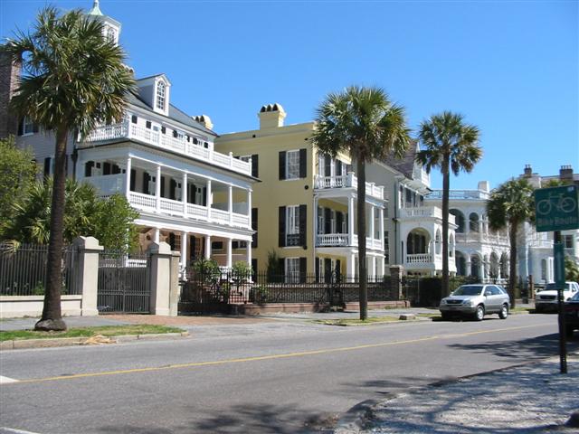
The Battery, a historic defensive seawall and promenade located at the tip of the peninsula along with White Point Garden, a park featuring several memorials and Civil War-era artillery pieces.
Calhoun Mansion, a 24,000-square-foot (2,200 m2), 1876 Victorian home at 16 Meeting Street, is named for a grandson of John C. Calhoun, who lived there with his wife, the builder's daughter. The private house is periodically open for tours.
Charleston Museum, America's first museum, founded in 1773.
Exchange and Provost, built in 1767, it is operated as a museum by the Daughters of the American Revolution.
Gibbes Museum of Art, opened in 1905, it houses principally American works with a Charleston or Southern connection.
Gov. William Aiken House, also known as the Aiken-Rhett House, is a house museum built in 1820.
Fireproof Building houses the South Carolina Historical Society, which offers a rotating series of historical displays.
Fort Sumter, the site of the first shots fired in the Civil War, is located in Charleston Harbor. The National Park Service maintains a visitor center for Fort Sumter at Liberty Square (near the South Carolina Aquarium), and boat tours including the fort depart nearby.
Halsey Institute of Contemporary Art at the College of Charleston, a free a non-collecting contemporary arts organization.
Heyward-Washington House, a historic house museum owned and operated by the Charleston Museum. The house is furnished in the late 18th century and includes a collection of Charleston-made furniture.
Kaynak: Wikipedia – Charleston, South Carolina · CC BY-SA 4.0