
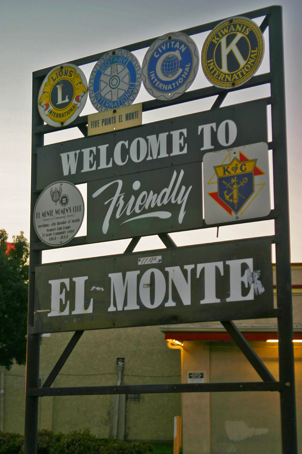

El Monte
El Monte, fundada en 1912, es una ciudad del condado de Los Ángeles en el estado estadounidense de California.
Government administration · United States · 0 followers
Overview
El Monte, fundada en 1912, es una ciudad del condado de Los Ángeles en el estado estadounidense de California. En el año 2000 tenía una población de 115.965 habitantes y una densidad poblacional de 4,688.4 personas por km². El eslogan de la ciudad es "the end of the Santa Fe Trail" y "Welcome to Friendly El Monte", que significan "el final del Tren Santa Fe" y "Bienvenido a la Amistosa El Monte". En 2002, El Monte era la 191ª ciudad más grande en los Estados Unidos. Fue también la 44 ciudad más grande de California. El Monte colinda con la región del Valle San Gabriel al este de la ciudad de Los Ángeles, uniéndose con la comunidad de Este de Los Ángeles.
Interested in working with us in the future?
Follow to see new jobs and posts in your feed.
No news yet.
About

El Monte, fundada en 1912, es una ciudad del condado de Los Ángeles en el estado estadounidense de California. En el año 2000 tenía una población de 115.965 habitantes y una densidad poblacional de 4,688.4 personas por km². El eslogan de la ciudad es "the end of the Santa Fe Trail" y "Welcome to Friendly El Monte", que significan "el final del Tren Santa Fe" y "Bienvenido a la Amistosa El Monte". En 2002, El Monte era la 191ª ciudad más grande en los Estados Unidos. Fue también la 44 ciudad más grande de California. El Monte colinda con la región del Valle San Gabriel al este de la ciudad de Los Ángeles, uniéndose con la comunidad de Este de Los Ángeles.
Kaynak: Wikipedia · CC BY-SA 4.0
Geografía
El Monte está localizada en las coordenadas 34°4′24″N 118°1′39″O (34.073276, -118.027491).
Según la Oficina del Censo de los Estados Unidos, la ciudad tenía un área total de 9.7 millas cuadradas (25.1 km²), de la cual, 9.6 millas cuadradas (24.7 km²) era tierra y el 0.1 millas cuadradas (0.4 km²) (1.44%) era agua.
Demografía
Según el censo del año 2000, había 115,965 personas, 27,034 hogares, y 23,005 familias residiendo en la ciudad. La densidad poblacional era de 12,139.5 personas por milla cuadrada (4,688.4/km²). Habían 27,758 casas unifamiliares en una densidad de 2,905.8/sq mi (1,122.2/km²). La demografía de la ciudad era del 35.67% caucásica, 0.77% afrodescendiente, 1.38% amerindia, 18.51% asiática, 0.12% isleños del pacífico, 39.27% de otras razas y el 4.29% de dos o más razas. 72.39% de la población era hispana o latina de cualquier raza.
Educación
El Distrito Unión de Escuelas Secundarias de El Monte consiste de las siguientes escuelas:
Fernando R. Ledesma High School, anteriormente conocida como Valle Lindo Continuation
San Gabriel Valley Conservation Corps, también conocida como San Gabriel Valley CC o SGVCC
El Monte Union High School Community Day
Ciudades hermanadas
El Monte se ha hermanado con las siguientes ciudades:
Demografi
2010 Nüfusu
15 Mart 2010 tarihinde yapılan nüfus sayımına göre şehrin nüfusunun 59.156 kişi, 824 ev ve 520 aileden oluştuğu belirlenmiştir. Şehrin nüfus dağılımın %98 Beyaz, %2,1 Afrikan Amerikan, %0,4 Yerli Amerikan, %0,7 Asyalı ve %0,2'sinin ise de diğer gruplardan oluştuğu belirlenmiştir.
2000 Sayımı
1 Nisan 2000 tarihinde yapılan nüfus sayımına göre şehrin nüfusunun 35.791 kişi, 7.104 ev ve 5.793 aileden oluştuğu belirlenmiştir. Şehrin nüfus dağılımın %98 Beyaz, %2,1 Afrikan Amerikan, %0,4 Yerli Amerikan, %0,7 Asyalı ve %0,2'sinin ise de diğer gruplardan oluştuğu belirlenmiştir.
Origin of name
El Monte is situated between the San Gabriel and Rio Hondo Rivers; a marshy area roughly where the Santa Fe Dam Recreation Area is now located. Residents claimed that anything could be grown in the area. Between 1770 and 1830, Spanish soldiers and missionaries often stopped here for respite. They called the area 'El Monte,' which in Spanish means 'the mountain' or 'the mount'. Most people assume the name refers to a mountain, but there were no mountains in the valley. The word is an archaic Spanish translation of that era, meaning "the wood". The first explorers had found this a rich, low-altitude land blanketed with thick growths of wispy willows, alders, and cattails, located between the two rivers. Wild grapevines and watercress also abounded. El Monte is approximately 7 miles long and 4 miles wide. When the State Legislature organized California into more manageable designated townships in the 1850s, they called it the El Monte Township. In a short time the name returned to the original El Monte.
History

Pre-1800s
The area, beside the San Gabriel River, is part of the homeland of the Tongva people as it has been for thousands of years. The Spanish Portolá expedition of missionaries and soldiers passed through the area in 1769–1770. Mission San Gabriel Arcángel was the center of colonial activities in the area. The site was within the Mexican land grant Rancho La Puente.
1800s
The Old Spanish Trail trade route was first established by Antonio Armijo in 1829. It passed through El Monte to its terminus at the Mission San Gabriel via what is now Valley Boulevard. The trade was woolen and other products from New Mexico for California horses and mules.
Using the Old Spanish Trail route at the end of 1841, a group of travelers and settlers, now referred to as the Workman-Rowland Party, arrived in the Pueblo of Los Angeles and this area in Alta California from Santa Fe de Nuevo México. Rowland and Workman became grantees of the Rancho La Puente in 1845.
The Old Spanish Trail from Santa Fe was continued east via the Santa Fe Trail trade route, established in 1821 as a trail and wagon road connecting Kansas City in Missouri Territory to Santa Fe, still within México.
From 1847, the Santa Fe Trail was also connected westward through the Southern Emigrant Trail, and in 1848 by the Mormon Road from Utah, passing by the El Monte area, to the Pueblo of Los Angeles. Immigrant settlement began in 1848, El Monte was a stopping place for the American immigrants going to the gold fields during the California Gold Rush. The first permanent residents arrived in El Monte around 1849–1850 mostly from Texas, Arkansas and Missouri, during a time when thousands migrated to California in search of gold. The first settlers with families were Nicholas Schmidt, Ira W. Thompson, G. and F. Cuddeback, J. Corbin, and J. Sheldon.
Geography
El Monte is located at 34°4′24″N 118°1′39″W (34.073276, -118.027491). According to the United States Census Bureau, the city has a total area of 9.6 square miles (25 km2), of which 9.6 square miles (25 km2) of it is land and 0.1 square miles (0.26 km2) of it (0.89%) is water.
Climate
El Monte has a Mediterranean climate (Köppen climate classification Csa).
Demographics
The population has increased by more than 40% since the 1970s, with homes replacing the walnut groves for which the city was known. There is historically a large Mexican and Latino community in El Monte.
2020
The 2020 United States census reported that El Monte had a population of 109,450. The population density was 11,452.3 inhabitants per square mile (4,421.8/km2). The racial makeup was 12.8% White, 0.8% African American, 2.2% Native American, 30.3% Asian, 0.1% Pacific Islander, 38.5% from other races, and 15.3% from two or more races. Hispanic or Latino of any race were 64.7% of the population.
The census reported that 98.6% of the population lived in households, 0.6% lived in non-institutionalized group quarters, and 0.8% were institutionalized.
There were 29,137 households, out of which 42.8% included children under the age of 18, 48.0% were married-couple households, 7.6% were cohabiting couple households, 26.6% had a female householder with no partner present, and 17.8% had a male householder with no partner present. 12.6% of households were one person, and 6.1% were one person aged 65 or older. The average household size was 3.71. There were 23,965 families (82.2% of all households).
The age distribution was 23.0% under the age of 18, 10.4% aged 18 to 24, 27.5% aged 25 to 44, 25.2% aged 45 to 64, and 13.9% who were 65 years of age or older. The median age was 36.3 years. For every 100 females, there were 98.6 males.
There were 29,893 housing units at an average density of 3,127.9 units per square mile (1,207.7 units/km2), of which 29,137 (97.5%) were occupied. Of these, 39.9% were owner-occupied, and 60.1% were occupied by renters.
In 2023, the US Census Bureau estimated that the median household income was $64,484, and the per capita income was $24,356. About 13.5% of families and 17.2% of the population were below the poverty line.
Government
Municipal government
The El Monte City Council has seven members—an elected Mayor and six council members elected by districts. The Mayor and City Council are elected by the voters of El Monte and are responsible for overseeing the delivery of local government services to the residents of the city.
State and federal representation
In the California State Senate, El Monte is in the 22nd senatorial district, represented by Democrat Susan Rubio. In the California State Assembly, it is split between the 48th Assembly district, represented by Democrat Blanca Rubio, and the 49th Assembly district, represented by Democrat Mike Fong.
In the United States House of Representatives, El Monte is in California's 31st congressional district, represented by Democrat Gil Cisneros.
Public safety
The City of El Monte has its own police department and contracts with the Los Angeles County Fire Department for fire services and emergency medical response.
The El Monte Police Department consists of 137 sworn police officers who provide emergency services to the citizens of El Monte. The current Chief of Police is Jake Fisher.
The City of El Monte Neighborhood Services Division provides enforcement of health and safety, municipal codes, zoning and building codes. Five Neighborhood Services Officers respond to complaints and proactively address violations. The Animal Control Division is also part of the Neighborhood Services Division. Animal Control Officers respond to all calls related to animals.
Economy
According to the city's 2018 Comprehensive Annual Financial Report, the top employers in the city are:
Cathay Bank has a corporate center in El Monte.
https://www.ci.el-monte.ca.us/DocumentCenter/View/3679/City-of-El-Monte-CAFR-2019-FINAL-PDF
Education
The El Monte Union High School District consists of the following schools:
Fernando R. Ledesma High School, Formerly known as Valle Lindo Continuation School
The El Monte City School District contains 17 elementary schools: one serving grades K-4, one serving grades K-5, ten serving grades K-6, and six serving grades K-8. The district also administers four Head Start (preschool) sites, which are located at the elementary schools.
The Mountain View School District is a K-8 school district comprising ten elementary schools, one intermediate school, one middle school, an alternative education program for students in grades 5–8, and a Children's Center and Head Start/ State Preschool program. The district has an enrollment of 8,600 students.
Children's Center/Head Start/State Preschool
Transportation
El Monte is served by Los Angeles Metro, Foothill Transit, and the city-operated El Monte Transit.
Metro's J Line ends at El Monte Metro station, while Foothill Transit's Silver Streak bus rapid transit passes through en route to Montclair station via the El Monte Busway. Train service to El Monte is provided by Metrolink's San Bernardino Line, which stops at the El Monte Metrolink station. Interstate 10 traverses El Monte. San Gabriel Valley Airport, a general aviation airport, is located in El Monte.
Health services
The Los Angeles County Department of Health Services operates the Monrovia Health Center in Monrovia, serving El Monte. The El Monte Comprehensive Health and Mammography Center is located on Ramona Blvd. in El Monte. It offers medical and dental services for low-income individuals, but is not an emergency center.
Media
El Monte community news is provided by the San Gabriel Valley Tribune which is published daily. Other local newspapers include Mid-Valley News and El Monte Examiner which are both published weekly.
In popular culture

El Monte is credited with being the birthplace of TV variety shows. Hometown Jamboree, a KTLA-TV Los Angeles-based show, was produced at El Monte Legion Stadium in the 1950s. The Saturday night stage show was hosted and produced by Cliffie Stone, who helped popularize country music in California.
In the 1950s, as the unstable racial climate and the hostility toward rock & roll started to emerge, rock & roll shows were forced from the City of Los Angeles by police pressure. The El Monte Legion Stadium, outside the city limits, became the site of a series for rock and roll concerts by Johnny Otis and other performers. (Johnny Otis along with Alan Freed and Dick Clark were the major powers in the growing rock and roll industry.) During the fifties, teenagers from all over Southern California flocked to El Monte Legion Stadium every Friday and Saturday night to see their favorite performers. Famous singers who performed there include: Ritchie Valens, Rosie & the Originals, Brenton Wood, Earth, Wind & Fire, The Grateful Dead, Dick Dale and his Del-Tones and Johnny "Guitar" Watson. Disc jockeys Art Laboe and Huggy Boy enhanced the stadium's popularity with their highly publicized Friday Night Dances with many popular record artists of the late 1950s and 1960s. "El Monte Legion Stadium", as it was often called, was the "Happening" place to be for the teenagers of that era. In a closed-circuit telecast, a recorded performance of The Beatles, the Beach Boys, and Lesly Gore aired in the El Monte Legion Stadium from Mar 14–15, 1964.
El Monte is known for the long-time rock & roll hit "Memories of El Monte", written by Frank Zappa and originally recorded by The Penguins, one of the local Doo-wop groups from the 1950s that became famous nationwide. The song is in remembrance of The El Monte Legion Stadium and can be heard on many albums including Art Laboe's Memories of El Monte. Although the stadium closed their doors nearly 50 years ago, the music continues to live on.
Kaynak: Wikipedia – El Monte, California · CC BY-SA 4.0