

Fort Smith
Fort Smith es la segunda ciudad más grande en el estado de Arkansas, Estados Unidos.
Government administration · United States · 0 followers
Overview
Fort Smith es la segunda ciudad más grande en el estado de Arkansas, Estados Unidos. Con una población estimada de 83 461 en 2006, es la ciudad principal del área metropolitana de Fort Smith, una región de 288.818 residentes que incluye los condados de Crawford, Franklin y Sebastian en Arkansas, y Le Flore y Sequoyah en Oklahoma. La ciudad es una de las dos sedes del condado de Sebastian. Está situada a orillas del río Arkansas.
Interested in working with us in the future?
Follow to see new jobs and posts in your feed.
No news yet.
About

Fort Smith es la segunda ciudad más grande en el estado de Arkansas, Estados Unidos. Con una población estimada de 83 461 en 2006, es la ciudad principal del área metropolitana de Fort Smith, una región de 288.818 residentes que incluye los condados de Crawford, Franklin y Sebastian en Arkansas, y Le Flore y Sequoyah en Oklahoma. La ciudad es una de las dos sedes del condado de Sebastian. Está situada a orillas del río Arkansas.
Kaynak: Wikipedia · CC BY-SA 4.0
Historia

Fort Smith fue fundada en 1817 como un asentamiento militar para vigilar el Territorio Indio. El fuerte fue abandonado en 1824, pero un pueblo fundado por John Roger se había formado junto al fuerte para ese entonces. En 1838, el fuerte fue reocupado y expandido y en 1871 fue abandonado de nuevo. Sin embargo, el pueblo continuó prosperando a pesar de la ausencia del fuerte.
Dos de los personajes históricos más notables fueron el Juez Isaac Parker y William Henry Harrison Clayton. En 1874, William Henry Harrison Clayton fue designado como Fiscal de los Estados Unidos para el Distrito Oeste de Arkansas por el presidente Ulysses S. Grant. Fort Smith era una creciente comunidad llena de burdeles, bares y criminales. William Clayton sabía que un juez fuerte sería necesario para traer la ley y el orden a la región y encontró un juez fuerte en Isaac Parker. Sin embargo, había un problema: el juez Parker había sido designado Juez Presidente del Territorio de Utah y confirmado por el Senado. Con la ayuda del presidente Grant y el senador Powell Clayton, antiguo gobernador de Arkansas, William Clayton fue capaz de deshacer la designación y redirigir al juez Parker a Fort Smith.
El juez Isaac Parker sirvió como Juez de Distrito desde 1875 hasta 1896. Fue apodado el "Juez de la Horca" porque en su primer término después de asumir el puesto juzgó a 18 personas por asesinato, condenando a 15 de ellos, sentenciando a ocho a morir y colgando a seis de ellos en un mismo día. Durante su carrera en Fort Smith, Parker sentenció a 160 personas a la horca, de las cuales 79 fueron ejecutados en la horca. El juez Parker representaba la única verdadera ley en el pueblo fronterizo durante esa época. Su tribunal es un Sitio Histórico Nacional en la actualidad.
William Clayton fue designado como Fiscal por cuatro distintos presidentes y más tarde sirvió como Juez Presidente del Territorio Indio. Él fue un elemento clave para lograr la condición de estado para Oklahoma y, junto con el gobernador territorial Frank Frantz, llevó la Constitución de Oklahoma al presidente Teddy Roosevelt. Tanto el gobernador Frantz como el juez Clayton perdieron sus posesiones territoriales cuando Oklahoma fue admitida en la Unión.
Geografía y clima
Fort Smith se localiza a 35°22′7″N 94°23′55″O, al oeste del estado, junto a la frontera con Oklahoma, sobre el curso bajo del río Arkansas, afluente del río Misisipi. Según la Oficina del Censo de los Estados Unidos, la ciudad tiene un área total de 137,1 km², de los cuales 130,4 km² corresponde a tierra y 6,7 km² (4,98%) a agua.
Fort Smith tiene un clima templado con inviernos suaves y veranos calientes y húmedos. La temperatura máxima promedio en los días de invierno es cerca de 10 °C, mientras que en el verano es 32 °C. Fort Smith se localiza cerca del área conocida como el Corredor de los Tornados en el centro de los Estados Unidos. La ciudad ha sido afectada por tres tornados grandes que ocurrieron en 1898, 1927 y 1996.
Base económica
Fort Smith ha sido un centro regional de manufactura durante mucho tiempo, con plantas operadas por Whirpool Corporation, Rheem, Trane, Georgia-Pacific, Gerber Products Company, Planters Peanuts, entre otros. En los últimos años, siguiendo la senda nacional, la ciudad ha perdido trabajo en el área de manufactura debido a que las líneas de producción se mudan al extranjero.
Transporte
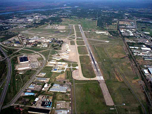
Fort Smith es un puerto de transporte importante para el área aledaña. Se encuentra en el cruce de dos autopista interestatales y es rodeado por el río Arkansas en tres lados. Además alberga un aeropuerto regional.
Carreteras
La ciudad se encuentra justo al suroeste de la intersección de la Interestatal 40 y la futura Interestatal 49 (actual Interestatal 540). La U.S. Route 71 y la U.S. Route 64 también pasan por la comunidad.
Transporte aéreo
Fort Smith alberga al Aeropuerto Regional de Fort Smith. Es usado para aviación militar por Fort Chaffee y el Escuadrón de vuelo 188 de la Guardia Área de Arkansas. También es usado por tres aerolíneas comerciales que viajan a Dallas, Memphis y Atlanta.
Bus
Jefferson Lines comunica a la ciudad con otras comunidades como Little Rock, Kansas City y Oklahoma City. También hay servicios para puntos intermedios, con numerosas conexiones a otras ciudades y pueblos.
Río
La ciudad se localiza junto al río Arkansas, parte del Sistema de Navegación McClellan-Kerr, y es servida por el Puerto de Fort Smith.
Transporte público
Dentro de la ciudad, un servicio de autobús público, llamado Fort Smith Transit, opera diversas rutas. Un trolebús opera en el centro de la ciudad, proveyendo transporte entre el Distrito Histórico Belle Grove y el Sitio Histórico Nacional de Fort Smith. El servicio de taxis es ofrecido por Razorback Cab.
Demografía
Para el censo de 2000, había 80.268 personas, 32.398 hogares y 20.637 familias en la ciudad. La densidad de población era 615,5 hab/km². Había 35.341 viviendas para una densidad promedio de 271,0 por kilómetro cuadrado. De la población 76,99% eran blancos, 8,65% afroamericanos, 1,69% amerindios, 4,59% asiáticos (especialmente vietnamitas y laos), 0,05% isleños del Pacífico, 5,03% de otras razas y 2,99% de dos o más razas. 8,78% de la población eran hispanos o latinos de cualquier raza. 7,10% reportaron hablar español en sus casas y 3,38% hablan vietnamita o lao.
Se contaron 32.398 hogares, de los cuales 30,8% tenían niños menores de 18 años, 47,1% eran parejas casadas viviendo juntos, 12,3% tenían una mujer como cabeza del hogar sin marido presente y 36,3% eran hogares no familiares. De 32.398 hogares, 1.388 era parejas no casadas: 1.259 heterosexuales, 84 parejas masculinas y 45 parejas femeninas. 30,7% de los hogares eran un solo miembro y 10,9% tenían alguien mayor de 65 años viviendo solo. La cantidad de miembros promedio por hogar era de 2,42 y el tamaño promedio de familia era de 3,03.
En la ciudad la población está distribuida con 25,4% menores de 18 años, 9,8% entre 18 y 24, 29,3% entre 25 y 44, 21,8% entre 45 y 64 y 13,7% tenían 65 o más años. La edad media fue 35 años. Por cada 100 mujeres había 94,1 varones. Por cada 100 mujeres mayores de 18 años, había 91,0 varones.
El ingreso medio para un hogar en la ciudad fue de $32.157 y el ingreso medio para una familia $41.012. Los hombres tuvieron un ingreso promedio de $29.799 contra $22.276 de las mujeres. El ingreso per cápita de la ciudad fue de $18.994. Cerca de 12,1% de las familias y 15,8% de la población estaban por debajo de la línea de pobreza, 22,2% de los cuales eran menores de 18 años y 9,6% mayores de 65.
Educación
La ciudad tiene una de las universidades parte del University of Arkansas System. La University of Arkansas – Fort Smith fue fundada en 1928 como una extensión del Sistema de Escuelas Públicas de Fort Smith, con el superintendente actuando como el presidente de la universidad y el director de la secundaria como el decano. Conocida originalmente como Fort Smith Junior College, la institución operó dentro del sistema escolar de Fort Smith hasta 1950, cuando la escuela fue incorporada como una institución privada, sin fines de lucro, con su propia junta administrativa. En septiembre de 1952, la universidad fue trasladada de sus instalaciones prestadas en la escuela secundaria a su ubicación actual, que inicialmente ocupaba 15 acres.
Durante este período, la inscripción de estudiantes aumento, así como la cantidad de cursos ofrecidos, los miembros de la facultad y las facilidades. Una división técnico-vocacional fue añadida en 1960. La institución empezó a desarrollar los programas y el carácter de una comunidad universitaria comprehensiva, un nuevo concepto en Arkansas y en los Estados Unidos.
Las escuelas públicas en Fort Smith son operadas por el Distrito Escolar Especial de Fort Smith. Actualmente, el distrito incluye 26 escuelas. Para el año escolar 2007-2008, el distrito tenía 13.900 estudiantes. Las escuelas públicas de Fort Smith proveen educación desde educación preescolar hasta el duodécimo grado, al igual que varias escuelas privadas protestantes. Escuelas parroquiales católicas ofrecen educación hasta el noveno año. Entre las escuelas secundarias públicas de Fort Smith están Northside High School y Southside High School. Entre las privadas destaca Union Christian Academy.
Personas destacadas
Figuras notables que nacieron, vivieron o están asociadas con Fort Smith.
Atletas
Ron Brewer, antiguo jugador de baloncesto.
Bryant Reeves, antiguo jugador de baloncesto.
Brian Martin, antiguo jugador de baloncesto.
Matt Jones, jugador profesional de fútbol americano.
Priest Holmes, jugador de fútbol americano. Ostenta el récord de la NFL de más touchdowns en una temporada.
Actores, músicos y escritores
Rudy Ray Moore, cantante y actor de cine.
Laurence Luckinbill, actor de TV, cine y teatro.
Katharine Alexander (1898-1981), actriz de cine.
Personajes históricos
William Orlando Darby, general y héroe de la Segunda Guerra Mundial.
Carolyn Pollan, antigua miembro de la Cámara de Representantes de Arkansas, la miembro del Partido Republicano y mujer que más ha servido en esa cámara.
Isaac Parker, conocido como el "Juez de la Horca".
Clifton R. Breckinridge (1846-1932), un concejal y congresista Demócrata, diplomático, empresario y veterano del Ejército Confederado.
Benjamin Bonneville (1796-1878), explorador.
History

Pre-European exploration
No evidence indicates permanent indigenous settlements at the time of European contact in what became Fort Smith. In southern Fort Smith, a platform mound known as the Cavanaugh Mound exists in isolation and may have served as a vantage point from which the Spiro Mounds in present-day Oklahoma could be seen in earlier centuries.
European exploration and early settlement
Hernando de Soto’s 1541 expedition into Arkansas may have reached as far west as the Fort Smith area. Place names such as Poteau, Belle Point, and Massard Prairie suggest later activity by French trappers who used the Arkansas River and its tributaries. The fertile Arkansas River Valley attracted early settlers, and Belle Point, a river bluff near the confluence of the Arkansas and Poteau rivers, provided a defensible location and broad visibility to the west.
Louisiana Purchase and early 19th century
In 1803, the United States acquired the region through the Louisiana Purchase. While the Lewis and Clark Expedition explored northern portions of the territory, the Pike Expedition of 1806 surveyed the southern areas along the Arkansas River.
In November 1817, U.S. Army troops established the first Fort Smith at Belle Point. The post was named for General Thomas Adams Smith, commander of the United States Army Rifle Regiment, although he never visited the site. The fort was initially intended to maintain peace between the Osage and Cherokee peoples. A small civilian settlement developed nearby. Major William Bradford commanded the post until its abandonment in 1824, when the Army relocated west to Fort Gibson.
John Rogers, an Army sutler and land speculator, purchased former government lands and promoted civilian growth. During the 1830s, amid federal Indian removal policies, the Army returned to Fort Smith and expanded the post. From this base, troops enforced the forced relocation of Southeastern tribes, including the Choctaw and Cherokee, to Indian Territory. The Cherokee later referred to this migration as the Trail of Tears. Many displaced people temporarily settled in Fort Smith and Van Buren.
Geography
According to the United States Census Bureau, the city has a total area of 64.6 square miles (167 km2), of which 61.7 square miles (160 km2) is land and 3.9 square miles (10 km2) (6.3%) is water.
Climate
Fort Smith has a humid subtropical climate with generally mild winters and hot, humid summers. The monthly mean temperature ranges from 40.4 °F (4.7 °C) in January to 83.1 °F (28.4 °C) in July; on average, the high stays at or below freezing on 3.8 days, reaches 90 °F (32 °C) on 77.8 days, and 100 °F (38 °C) on 11.1 days annually. The average first and last occurrences for freezing temperatures are November 6 and March 25, respectively. Extreme temperatures range from −15 °F (−26 °C) on February 12, 1899 to 115 °F (46 °C) on August 3, 2011. Fort Smith is situated near an area known as Tornado Alley in the central United States. The city has been struck by three major tornadoes, which occurred in the years of 1898, 1927 and 1996.
Demographics
2020 census
As of the 2020 census, Fort Smith had a population of 89,142. A total of 22,349 families resided in the city.
The median age was 36.9 years. 23.7% of residents were under the age of 18 and 15.9% of residents were 65 years of age or older. For every 100 females there were 94.4 males, and for every 100 females age 18 and over there were 92.1 males age 18 and over.
98.8% of residents lived in urban areas, while 1.2% lived in rural areas.
There were 36,266 households in Fort Smith, of which 29.8% had children under the age of 18 living in them. Of all households, 39.4% were married-couple households, 21.3% were households with a male householder and no spouse or partner present, and 31.2% were households with a female householder and no spouse or partner present. About 32.6% of all households were made up of individuals and 12.1% had someone living alone who was 65 years of age or older.
There were 40,327 housing units, of which 10.1% were vacant. The homeowner vacancy rate was 2.3% and the rental vacancy rate was 10.1%.
2010 census
As of the 2010 census, there were 86,209 people, 34,352 households, and 21,367 families residing in the city. The population density was 1,391.2 inhabitants per square mile (537.1/km2). There were 37,899 housing units at an average density of 612.3 per square mile (236.4/km2). The racial makeup of the city was 69.3% White, 9.0% Black or African American, 1.8% Native American, 5.3% Asian (2.2% Vietnamese, 1.7% Laotian, 0.3% Asian Indian, 0.2% Filipino, 0.1% Korean, 0.1% Chinese, 0.1% Hmong, 0.1% Pakistani), 0.1% Pacific Islander, 10.3% from other races, and 4.2% from two or more races. 16.5% of the population were Hispanic or Latino of any race (11.6% Mexican, 2.2% Salvadoran, 0.4% Guatemalan, 0.3% Puerto Rican, 0.2% Honduran, 0.1% Cuban, 0.1% Peruvian, 0.1% Colombian).
Economy
Fort Smith has long been a regional manufacturing center, with major plants located in the city operated by Rheem, Trane, Georgia-Pacific, Gerber, Kraft Heinz Company-Planters Peanuts, Mars Petcare, Umarex USA, Graphic Packaging, International Paper, Pernod Ricard-USA, and many others.
Fort Smith is home to several corporations, including ABB Motors & Mechanical, ArcBest and poultry company OK Foods.
According to the city's 2024 Annual Comprehensive Financial Report, the top employers in the city are:
Culture

Various television programs and movies have been filmed in Fort Smith, including The Blue and The Gray (1982), A Soldier's Story (1984), Biloxi Blues (1988) Trespass and Tuskegee Airmen (1995)
Museums
There are several museums in Fort Smith, located primarily in the downtown area and the Chaffee Crossing Historic District.
Fort Smith Regional Art Museum opened to the public on January 19, 2013.
Fort Smith Museum of History, located almost adjacent to the National Historic Site. The museum contains numerous exhibits, displays and artifacts that tell the story of Fort Smith's history—from the first fort in 1817, through the westward expansion, and on to the Civil War, the Gay Nineties, Fort Chaffee, and the emergence of a modern city.
Fort Smith Trolley Museum is a railroad museum which displays a number of antique trolleys and related items. One of the trolley cars and three of the locomotives in its collection are listed on the National Register of Historic Places.
Fort Smith Air Museum is dedicated to preserving the history of the development of aviation in Western Arkansas and Eastern Oklahoma.
The Clayton House Museum is the original home of William H.H. Clayton. It is open for tours and rentals for weddings, meetings, events, and much more. The house holds many Clayton artifacts, and boldly tells the history of Mr. Clayton as well as the western frontier
Chaffee Barbershop Museum - located in the Chaffee Crossing Historic District in east Fort Smith, this museum was the location where, on March 25, 1958, Elvis Presley received his iconic G.I buzz cut
The United States Marshals Museum documents the heritage and legacy of the United States Marshals Service, America's oldest federal law enforcement agency.
Music
Fort Smith has an active music scene. There are frequent live performances in the downtown area by local and national Jazz, Blues, Country, Americana and Rock bands.
Attractions

As the third largest city in Arkansas, Fort Smith offers many activities and attractions. Fort Smith's theater and event venues regularly host major concerts and touring theater companies.
Event venues
Riverfront Amphitheater - Located next to the Arkansas River, the Riverfront Amphitheater represents one-third of the River Park Complex.
Fort Smith Convention Center, with 140,000 square feet of space, is one of the largest convention centers in the region, second only to Little Rock's Statehouse Convention Center, with 225,000 square feet. Fort Smith Convention Center has more than 40,000 square feet (3,700 m2) of exhibition space. Many trade shows, conventions, and other events are held here each year. The performing arts theater is home to the Fort Smith Symphony and has seating for 1,331 people.
Kay Rodgers Park - site of the Expo Center, with 24,000 square feet (2,200 m2) of meeting and exhibition space, and the Harper Arena, which is a covered open-air stadium that can seat 7,000 to 14,000 attendees for a variety of events.
The Blue Lion - This Performing and Visual Arts Center has an intimate 250-seat theater and 1,500 square feet (100 m2) Art Gallery.
Shopping
Fort Smith is the main shopping destination of Western Arkansas and Eastern Oklahoma. Central Mall is the city's largest indoor shopping center in terms of area.
Some notable shopping locations in the city of Fort Smith are:
Landmarks
Fort Smith National Historic Site, the most prominent landmark, which includes the remains of the original 1817 fort on the Arkansas River. Inside is the restored courtroom of the famed "Hangin' Judge" Isaac C. Parker, and the dingy frontier jail aptly named "Hell on the Border." Eventually, this would become the unofficial nickname for all of Fort Smith.
Belle Grove Historic District, a 22-block area in downtown Fort Smith comprises nearly 25 restored homes that span 130 years of varying architectural styles.
Sports and recreation
In addition to sports teams sponsored by Fort Smith Public Schools and University of Arkansas-Fort Smith, Fort Smith has several independent recreational sports programs and annual tournaments administered by local organizations:
Fort Smith Marshals (Mid America Baseball League)
Battle at the Fort Volleyball Tournament - held each January at the Fort Smith Convention Center
United Way Charity Golf Classic - May 2020 at Hardscrabble Country Club
Fort Smith Tournament of Champions - high school basketball tournament
Education

Higher education
The city has one major university that is part of the University of Arkansas System. The University of Arkansas at Fort Smith was founded in 1928 as an extension of the Fort Smith Public School system, with the superintendent, James William Ramsey, acting as the college president and the high school principal as dean. Known originally as Fort Smith Junior College, the institution operated within the Fort Smith public school system until 1950, when the school was incorporated as a private, nonprofit institution with its own governing board. In September 1952, the college moved from borrowed facilities in the high school to its current site, initially occupying 15 acres (6.07 ha).
In 1966, the institution's name was changed from Fort Smith Junior College to Westark Junior College and in 1972, it was renamed Westark Community College, indicating the larger area to be served and reflecting the more comprehensive mission.
The name of the college was changed yet again in February 1998 to Westark College, more accurately portraying the role and scope of the institution.
On December 15, 2000, the Board of Trustees of Westark College entered into an agreement with the Board of Trustees of the University of Arkansas to merge with the University of Arkansas System as a four-year institution. In 2001, the Sebastian County electorate voted to support the merger. A formal request to change affiliation status to that of a bachelor's degree-granting institution under the name of the University of Arkansas at Fort Smith was submitted to the Higher Learning Commission in August 2001 and approved by the Institutional Actions Council on November 19, 2001.
The merger, which became official on January 1, 2002, endorsed the concept of UA-Fort Smith as a unique university, one that offers applied and traditional baccalaureate degree programs, one- and two-year associate and technical programs, and noncredit business and industry training programs. While the University of Arkansas at Fort Smith is the city's only state supported institution of higher learning.
Media
The Southwest Times Record is the largest newspaper in the city, as well as the region. It is owned by the USA Today Co.. The Hispanos Unidos is the only Spanish-language publication in the region. Other publications in the Fort Smith area include Entertainment Fort Smith and Do South Magazine.
Radio
AM radio Stations in the Fort Smith area include:
FM Radio Stations in the Fort Smith area include:
Television
Television stations in the Fort Smith area include:
Infrastructure
Transportation
Fort Smith is a major transportation hub for the surrounding region. It sits at the crossroads of two major interstate highways, is surrounded on three sides by the Arkansas River, is served by 1 major and 2 regional/switching railroad companies, and is the home of a regional airport.
The city sits just southwest of the intersection of Interstate 40 and Interstate 49. Interstate 49 will extend southward to meet Interstate 30 in Texarkana, Texas. US 71 and US 64 also run through the community.
Fort Smith is served by the Fort Smith Regional Airport (FSM), which is used for military aviation for Fort Chaffee and home of the 188th Fighter Wing of the Arkansas Air National Guard, and is served by one commercial airline with flights to Dallas/Fort Worth.
Jefferson Lines bus service also links Fort Smith to other communities such as Little Rock, Kansas City, and Oklahoma City, as well as intermediate points, with numerous connections to other cities and towns.
The city is located on the Arkansas River, part of the McClellan-Kerr Navigation System and is served by the Port of Fort Smith.
Fort Smith is served by the Kansas City Southern Railway from a branch connection on the mainline at Poteau, Oklahoma, and affords connections to other railroads at Kansas City, Missouri, and at New Orleans, Louisiana. In addition, the regional railroad company, the Arkansas and Missouri Railroad directly serves Fort Smith and provides connections through the St. Louis, Missouri, and Memphis gateways to the east. The Fort Smith Railroad provides local switching service to a variety of businesses as well as providing haulage for the Union Pacific Railway with which it connects at Van Buren, Arkansas. At this time, there is no direct passenger service from Amtrak. The closest point for such service is Little Rock.
Sister cities
Fort Smith has a sister city relationship with Cisterna di Latina, Italy, site of the World War II Battle of Cisterna, fought by United States Army Rangers commanded by Fort Smith native William Orlando Darby. The city also has a mutual friendship-city relationship with Jining, China.
Kaynak: Wikipedia – Fort Smith, Arkansas · CC BY-SA 4.0