


Fürth
Fürth ist eine kreisfreie Großstadt im bayerischen Regierungsbezirk Mittelfranken.
Government administration · Germany · 0 followers
Overview
Fürth ist eine kreisfreie Großstadt im bayerischen Regierungsbezirk Mittelfranken. Sie bildet mit Nürnberg und Erlangen das Kerngebiet des Ballungsraums Nürnberg, zu dem auch Schwabach zählt. Zusammen mit dem Umland handelt es sich um einen Teil der Metropolregion Nürnberg, eine von drei Metropolregionen in Bayern. Mit 131.344 Einwohnern ist die Großstadt nach Nürnberg und Würzburg die drittgrößte Stadt Frankens und die siebtgrößte Stadt in Bayern.
Interested in working with us in the future?
Follow to see new jobs and posts in your feed.
No news yet.
About

Fürth ist eine kreisfreie Großstadt im bayerischen Regierungsbezirk Mittelfranken. Sie bildet mit Nürnberg und Erlangen das Kerngebiet des Ballungsraums Nürnberg, zu dem auch Schwabach zählt. Zusammen mit dem Umland handelt es sich um einen Teil der Metropolregion Nürnberg, eine von drei Metropolregionen in Bayern. Mit 131.344 Einwohnern ist die Großstadt nach Nürnberg und Würzburg die drittgrößte Stadt Frankens und die siebtgrößte Stadt in Bayern.
Kaynak: Wikipedia · CC BY-SA 4.0
Geographie

Lage und Fläche
Der historische Stadtkern befindet sich östlich und südlich der Flüsse Rednitz und Pegnitz, die nordwestlich der Altstadt zur Regnitz zusammenfließen. Westlich der Stadt, jenseits von Südwesttangente und Main-Donau-Kanal, steigt der Fürther Stadtwald an. Östlich der Stadt liegt in etwa gleicher Höhe die direkt anschließende Stadt Nürnberg. Nördlich dehnt sich das fruchtbare, teilweise zum Stadtgebiet gehörende Knoblauchsland aus. Südlich der Stadt liegt ein Mischgebiet aus breiten Autostraßen, Kanal und Flussauen.
Der höchste Geländepunkt ist der Steinbruch in Burgfarrnbach mit 392,3 m ü. NHN, der niedrigste liegt im Regnitztal an der Stadtgrenze zu Erlangen auf 278 m ü. NHN, das Rathaus im Stadtzentrum liegt auf 294,9 m ü. NHN.
Die Fläche des Stadtgebietes beträgt 63,36 km², die Länge der Stadtgrenze 50,05 Kilometer. Der Abstand zwischen dem östlichsten und dem westlichsten Punkt des Fürther Stadtgebietes beträgt 9,835 Kilometer, zwischen dem nördlichsten und dem südlichsten Punkt 11,704 Kilometer.
Stadtgliederung
Die Gemeinde hat 21 Gemeindeteile (in Klammern ist der Siedlungstyp angegeben):
Es gibt auf dem Gemeindegebiet zehn Gemarkungen: Burgfarrnbach, Dambach, Fürth, Fürther Stadtwald, Poppenreuth, Ronhof, Sack, Stadeln, Unterfarrnbach und Vach. Die Gemarkung Fürth hat eine Fläche von 12,867 km². Sie ist in 10472 Flurstücke aufgeteilt, die eine durchschnittliche Flurstücksfläche von 1228,68 m² haben. In ihr liegt neben dem namensgebenden Ort der Gemeindeteil Weikershof.
Nachbargemeinden
Folgende Städte und Gemeinden grenzen an die Stadt Fürth, sie werden nach dem Uhrzeigersinn beginnend im Norden genannt:
Erlangen und Nürnberg (beide kreisfrei), Oberasbach, Zirndorf, Cadolzburg, Seukendorf, Veitsbronn und Obermichelbach (alle Landkreis Fürth).
Geschichte

Von den Anfängen bis zum 19. Jahrhundert
Erstmals genannt ist die Ansiedlung Fürth in einer ottonischen Urkunde am 1. November 1007, mit der König (später Kaiser) Heinrich II den Ort dem neu gegründeten Domkapitel Bamberg vermachte. Das in den folgenden Jahren zugesprochene Marktrecht ging bereits unter Heinrich III. an das benachbarte Nürnberg verloren. Auch wenn ab 1062 in Fürth wieder Markt abgehalten werden durfte, so war in dieser Zeit Nürnberg bereits von größerer Bedeutung.
Seit 1440 sind erste Ansiedelungen von Juden in Fürth überliefert, die in den folgenden Jahrhunderten auch einen eigenen Friedhof und eine Synagoge begründeten. Die Markgrafen von Ansbach, die Dompropstei in Bamberg und die Reichsstadt Nürnberg übten ab dem 15. Jahrhundert die Herrschaft bis 1792 aus, wobei es oft Streitigkeiten gab („Dreiherrschaft“).
Durch das nahe Nürnberg blieb Fürth lange Zeit ein bäuerlich geprägtes Gemeinwesen, das um 1600 wohl erst zwischen 1000 und 2000 Einwohner hatte. Im Dreißigjährigen Krieg litt der Ort sehr, am schlimmsten im Jahre 1632 durch die Schlacht an der Alten Veste und im Jahre 1634, als Fürth bis auf wenige Häuser niedergebrannt wurde.
Bis 1792 lag die Herrschaft über die Stadt zu unterschiedlichen Teilen und in wechselnden Ausgestaltungen bei dem Bamberger Domstift, dem Fürstentum Ansbach und der Reichsstadt Nürnberg (siehe dazu Karte von 1717 rechts). Durch die Abdankung des letzten Markgrafen von Brandenburg-Ansbach-Bayreuth, Christian Friedrich Carl Alexander, endete 1792 die bisherige „Dreiherrschaft“, Fürth wurde preußisch. 1806 ging Fürth an Bayern und wurde Stadt.
Im 18. Jahrhundert entstand der städtische Charakter, der in der heutigen Altstadt in wesentlichen Grundzügen noch ersichtlich und teilweise erhalten ist. Siehe Karte des bayerischen Urkatasters von 1808. 1835 fuhr mit dem Adler die erste deutsche Eisenbahn zwischen Nürnberg und Fürth (Ludwigseisenbahn). Bedeutend war der Einfluss der Industrialisierung, als 1843 der Ludwig-Donau-Main-Kanal die Stadt erreichte. 1864/65 bestanden mit der Ludwigs-Süd-Nord-Bahn und der Ludwigs-West-Bahn die ersten Fürther Bahnfernverbindungen.
Religionen und Weltanschauungen

Konfessionsstatistik
Gemäß dem Zensus 2022 waren 28,1 % der Einwohner evangelisch, 19,5 % römisch-katholisch und 52,4 % waren konfessionslos oder gehörten einer anderen Glaubensgemeinschaft an. Am Stichtag 31. Dezember 2025 waren nach Recherchen der Forschungsgruppe Weltanschauungen in Deutschland 24,0 % der Einwohner der Stadt evangelisch, 16,8 % römisch-katholisch und 59,2 % waren konfessionslos oder gehörten einer sonstigen Glaubensgemeinschaft an. Die Zahl der evangelischen und katholischen Kirchenmitglieder ist demnach in diesem Zeitraum gesunken, während der Anteil der Konfessionslosen zunahm.
Christentum
Fürth zählte anfangs zum Bistum Würzburg, ab 1007 zum Bistum Bamberg. 1524 wurde zusammen mit der Stadt Nürnberg die Reformation eingeführt, so dass Fürth über viele Jahre eine protestantische Stadt war. Die lutherischen Geistlichen der Stadt wurden von St. Lorenz in Nürnberg präsentiert. Da neben der Reichsstadt Nürnberg u. a. auch die Dompropstei Bamberg die Stadtherrschaft ausübte, gab es jedoch stets Katholiken – wenn auch zahlenmäßig nur sehr wenige – in der Stadt. So wurden z. B. der dompropsteiliche Amtmann und seine Bediensteten vom Deutschordenshaus Nürnberg betreut.
Nach 1792 wurden die protestantischen Gemeinden Fürths dem königlich-preußischen Konsistorium in Ansbach unterstellt, und nach dem Übergang der Stadt an Bayern wurden sie Teil der Protestantischen Kirche des Königreichs Bayern, die zunächst lutherische und reformierte Gemeinden umfasste. Die Kirchengemeinden gehörten dann zum Dekanat Zirndorf. 1885 wurde Fürth Sitz eines eigenen Dekanats, das zum Kirchenkreis Nürnberg gehört.
Spätestens seit dem 18. Jahrhundert nahm die Zahl der Katholiken in der Stadt wieder zu. Im Jahre 1829 konnte die erste katholische Kirche der Stadt seit der Reformation geweiht werden, die Kirche „Zu Unserer Lieben Frau“. Später entstanden weitere Pfarrgemeinden, die zunächst zum Dekanat Nürnberg des Erzbistums Bamberg gehörten. 1961 wurde Fürth Sitz eines eigenen katholischen Dekanats innerhalb des Erzbistums.
Politik

Wappen
Die Stadt erhielt 1818 nach der Stadterhebung zur Stadt erster Klasse ein neues Wappen. Es besteht aus einem grünen Kleeblatt, umgeben von einem grünen Eichenzweig. Beides wird eingefasst durch die Zeichen der Stadt – einer Mauerkrone mit vier Türmen. Dieses Wappen wurde über 100 Jahre lang geführt. 1939 wurde das Stadtwappen vereinfacht. Aus einem Schreiben vom Reichsstatthalter Franz Ritter von Epp ist zu entnehmen, dass die Mauerkrone und der Eichenzweig entfernt wurden. Lediglich das Kleeblatt mit einer Umrandung blieb erhalten. Seit 1939 hat sich das offizielle Wappen der Stadt Fürth nicht geändert. Für offizielle Anlässe, wie z. B. Ehrungen der Stadt Fürth, wird stets das Originalwappen von 1939 verwendet, wohingegen sich seit 1960 eine etwas „modernere“ Fassung des Kleeblatts mit Umrandung in den einschlägigen Medien durchgesetzt hat.
Gleichzeitig erhielt die Stadt eine Flagge, die in Weiß zwei grüne Streifen und im grünen Oberteil das Wappen zeigte. Später wurde die Flagge auf die Farben Weiß (oben) und Grün (unten) vereinfacht.
Die Stadtfarben sind Weiß und Grün. Auch das Stadtlogo besteht aus den Umrissen eines grünen Kleeblatts. Dieses ist auf der rechten Seite zwischen Blatt und Stil nicht geschlossen. Stattdessen befindet sich hier in schwarz und zweizeilig geschrieben der Name Stadt Fürth. Die aktuelle Version wird seit dem 13. September 2017 verwendet.
Stadtrat
Der Stadtrat der Stadt Fürth setzt sich aus 50 Stadträten und dem Oberbürgermeister zusammen. Ab 1. Mai 2026 verfügt die Fraktion der SPD mit 21 Stadträten plus Oberbürgermeister wie bisher über eine relative Mehrheit. Zweitgrößte Fraktion ist die Fraktion der CSU, dann die Fraktion der Grünen. (Stand 2026)
¹ bis 2002 BL: Bürgerliste → ab 2008 FW: Freie Wähler
Stadtoberhaupt
Die Stadt wurde bis gegen Ende des 18. Jahrhunderts von einem dompropsteilich-bambergischen Amtmann geleitet. Aus der Stadt wurden zwei Bürgermeister gewählt, bis 1697 vier, ab 1718 acht. Ihnen standen „Vorsteher“ zur Seite.
Kultur und Sehenswürdigkeiten

Theater
An drei Spielorten bietet das Stadttheater Fürth spartenübergreifend Theater- und Musikveranstaltungen. Mit dem „3-Stufen-Modell“ bestehend aus Gastspielen, Koproduktionen und Eigenproduktionen präsentiert das Stadttheater Fürth Schauspiel, Musiktheater, Tanz, Konzerte und Kinder- und Jugendtheater.
Das Gebäude wurde 1902 nach Plänen der Wiener Theaterarchitekten Fellner und Helmer erbaut, die sich an Formen der italienischen Renaissance und des Barock orientierten. Das Fürther Stadttheater hat große Ähnlichkeiten mit dem von den gleichen Architekten errichteten Stadttheater der ukrainischen Stadt Czernowitz.
Comödie
Die Comödie Fürth im Jugendstilbau Berolzheimerianum wurde von den fränkischen Komödianten Volker Heißmann und Martin Rassau gegründet. Beide sind national bekannt in ihren Paraderollen von Waltraud und Mariechen in Fürther Mundart. Die Comödie Fürth fungiert dazu als Spielstätte von Ensembles anderer renommierter deutscher Boulevardtheater.
Kulturforum
Neben den etablierten Veranstaltungsstätten entwickelte sich seit 1989 das Kulturforum Fürth. Im alten Schlachthof findet sich unter anderem das kommunal geförderte Programmkino Ufer-Palast der Kino-Kooperative Fürth e. V. mit zwei Sälen. Das Kulturforum ist auch die bevorzugte Spielstätte der Bühne Erholung 27, einem Amateurtheaterverein.
Im Jahre 2002 wurde der Schlachthof komplett saniert und zum heutigen Kulturforum Fürth umgebaut. Auf dem Areal des ehemaligen Schlachthofs, am Flussufer der Rednitz nahe der Fürther Altstadt gelegen, befindet sich das Kulturforum Fürth mit zwei Spielstätten und einem Programm aus Konzerten, Kleinkunst und Kabarett, Literatur und Lesungen, bildender Kunst, Filmen (Programmkino Uferpalast), Theaterinszenierungen, sonstigen Veranstaltungen (wie ein Figurentheaterfestival oder ein Internationales Klezmerfestival).
Wirtschaft und Infrastruktur

Im Jahre 2016 erbrachte Fürth, innerhalb der Stadtgrenzen, ein Bruttoinlandsprodukt (BIP) von 4,170 Milliarden €. Das BIP pro Kopf lag im selben Jahr bei 33.415 € (Bayern: 44.215 €/ Deutschland 38.180 €) und damit deutlich unter dem regionalen und nationalen Durchschnitt. In der Stadt gab es 2016 ca. 61.300 erwerbstätige Personen. Die Arbeitslosenquote lag im Dezember 2018 bei 4,6 % und damit über dem bayerischen Durchschnitt von 2,7 % (im Landkreis Fürth betrug sie 2,4 %).
Im Zukunftsatlas 2016 belegte die kreisfreie Stadt Fürth Platz 96 von 402 Landkreisen, Kommunalverbänden und kreisfreien Städten in Deutschland und zählt damit zu den Orten mit „Zukunftschancen“. In der Ausgabe von 2019 lag sie auf Platz 85 von 401.
Die Spielwarenindustrie ist in Fürth ein wesentlicher Wirtschaftsfaktor; vom kleinen Handwerksbetrieb bis zum großen Industrieunternehmen ist auf diesem Sektor alles vertreten, so sind etwa die Spielzeugproduzenten der Simba-Dickie-Group und Bruder Spielwaren in Fürth beheimatet.
Unternehmen
Am 26. Oktober 1927 gründete Gustav Schickedanz das Versandhaus Quelle, das Unternehmen war bis zur Liquidation größtes Versandhaus Europas und hatte in Fürth seinen Hauptsitz. Die Versicherungsgruppe Ergo Direkt ging 1984 aus dem damaligen Einzelhandelskonzern Quelle hervor. Nach mehrjährigem Umbau des Gebäudes der ehemaligen Hauptverwaltung des Quelle-Versandhauses ist dieses seit dem 1. Oktober 2016 der Hauptsitz des Bayerischen Landesamts für Statistik mit ca. 290 Mitarbeitern.
In der Nachkriegszeit gründete Max Grundig in Fürth sein Imperium mit dem Radiobausatz Heinzelmann. Die Grundig AG unterhielt von ihrer Gründung bis Mitte 2000 ihren Hauptsitz, zeitweise die gesamte Produktentwicklung sowie mehrere Fertigungsstandorte in Fürth. Die Verbundenheit zeigte sich im Konzernlogo, welches lange Zeit ein gekröntes Stadtwappen war. Die ehemalige Zentrale von Grundig an der Kurgartenstraße (vormals Fürths erstes Thermalbad) wurde zum Technologiepark Uferstadt Fürth umgebaut, in der das Rundfunkmuseum Fürth, das Technikum Neue Materialien, ein Fraunhofer-Institut, Sellbytel und das IT-Dienstleistungsunternehmen Atos einen Standort gefunden haben.
Kaynak: Wikipedia – Fürth · CC BY-SA 4.0
Tarihçe
Şehrin 8. yüzyılın ortalarında Franklarca kurulduğu düşünülse de şehrin varlığına dair en eski kayıtlar 1 Kasım 1007 tarihine kadar uzanmaktadır. Bu tarihte yeni oluşturulan Bamberg piskoposluğuna bağlanan Fürth, ilerleyen yıllarda pazar kasabası statüsü aldı. Otuz Yıl Savaşları sırasında çıkan yangınlar sonrası neredeyse tamamen yıkıma uğrayan yerleşme, 1835'te Bayerische Ludwigsbahn adı verilen Almanya'nın ilk demiryolu hattı üzerinde yer aldı.
Kaynak: Wikipedia – Fürth · CC BY-SA 4.0
Geography
The historic centre of the town is to the east and south of the rivers Rednitz and Pegnitz, which join to form the Regnitz to the northwest of the Old Town. To the west of the town, on the far side of the Main-Danube Canal, is the Fürth municipal forest (Fürther Stadtwald). To the east of Fürth, at roughly the same latitude, lies Nuremberg, and to the north is the fertile market-gardening area known as the Knoblauchsland (garlic country), some of which is within the borders of the urban district of Fürth. To the south of the town is an area consisting of wide roads, the canal, and meadows.
Neighbouring municipalities
The following towns and municipalities share borders with Fürth; they are listed in clockwise order, starting in the north:
Erlangen and Nuremberg, which are independent urban districts; Stein, Oberasbach, Zirndorf, Cadolzburg, Seukendorf, Veitsbronn, and Obermichelbach, which are municipalities within the rural district (Landkreis) of Fürth.
Parts of town
Beyond the town proper, the urban district comprises another 20 localities:
History

Founded as a Franconian settlement in the mid-8th century AD, the first historical mention of Fürth was in a document dated 1 November 1007, in which the Emperor Heinrich II donated his property in Fürth to the newly created Bishopric of Bamberg. The name "Fürth" derives from the German word for "ford", as the first settlements originated around a ford. In the following years, Fürth was granted market privileges, but these were later lost to the neighbouring Nuremberg, under Heinrich III. From 1062 onward, Fürth was again permitted to have a market, but by that time Nuremberg was already the more important town.
In the following centuries, the town was under varying authority, involving the Bishopric of Bamberg, the Principality of Ansbach and the City of Nuremberg. For a long time, the character of the settlement remained largely agricultural, and in 1600 the population was probably still only between 1000 and 2000.
In the Thirty Years War, the village was almost completely destroyed by fire, in military actions leading up to the September 1632 Battle of Fürth.
In 1835, the first German railway was opened between Nuremberg and Fürth.
Throughout the Cold War, Fürth had a significant NATO presence, especially the U.S. Army, due to its proximity to both the East German and Czechoslovak borders.
Expansion
In the course of time, a number of municipalities or other administrative divisions were integrated into the urban district of Fürth:
1 January 1899: the western part of the municipality of Höfen, including Weikershof (to the south of the Schwabacher Straße)
1 January 1900: the municipality of Poppenreuth (to the east of the historic centre of the city, on the far side of the river Pegnitz)
1 January 1901: the municipality of Dambach (to the west of the current Südstadt (South Town), as well as Unterfürberg and Oberfürberg
Religions

Christianity
The population of Fürth was originally under the Bishopric of Würzburg and from 1007 it belonged to the Bishopric of Bamberg. In 1524, as part of the Reformation, it became a Protestant town like Nuremberg, and it remained so for many years. However, because of the connections with Bamberg, there were always some Catholics in the town.
After 1792, the Protestant congregations in Fürth were under the authority of the Prussian Ansbach Consistory, and when Brandenburg-Ansbach was ceded to Bavaria they became part of the Bavarian Protestant Church, which initially comprised Lutheran and Reformed congregations. The congregations later belonged to the Deanery of Zirndorf. In 1885, Fürth became a deanery (Dekanat), subsidiary to Nuremberg.
Beside the Bavarian Protestant Church there are also Protestant congregations of free churches in Fürth, e. g. a small congregation of the United Methodist Church.
From the 18th century or earlier, the number of Catholics rose, and in 1829 the first Catholic church since the Reformation was consecrated: the Church of Our Lady. St. Michael was originally a Catholic church until taken by the Protestants during the Reformation. In 1961, Fürth became a Catholic Deanery within the Archdiocese.
The proportion of Protestants to Catholics in the 20th century was about two to one.
Judaism
The position enjoyed by Jews in Fürth (compared with other towns) led to the sobriquet "Franconian Jerusalem", though this is based on an older, pejoratively intended reference to Fürth.
Jewish residents are mentioned as early as 1440; in 1528 the Margrave of Ansbach, George the Pious, permitted two Jews, Perman and Uriel, to settle in Fürth (in return for high taxes), and from then on the number of Jewish residents increased.
By the 17th century, there was a local Yeshiva (Talmudic academy, Fürth Yeshiva) of considerable repute, and in 1617, a synagogue was built. In 1653, the first Jewish hospital in Germany (and Fürth's first hospital) was built.
Nature
The "Nature Trail for Urban Ecology" was established in 1999 (3 km (1.9 mi), 10 stops) and expanded in 2003 to include a second route (7 km (4.3 mi), 10 stops). Both tours begin at the Stadthalle underground railway station. Along the nature trail, different habitats and their importance for the flora and fauna of the area are explained (e.g. the churchyard of St. Michael's Church, the municipal cemetery, Scherbsgraben stream). The trail references the designation of some areas as protected areas, and explains problems of measures that affect the environment, such as river regulation.
Average sunshine duration is 1766 hours per year.
The Gustav-Adolf natural spring, near Weikershof, by the River Rednitz was restored in 2000 and a pavilion was erected. Until the 1980s, the spring water, which comes out of the ground at 19 °C (66 °F), was used for a swimming pool.
Politics
Coat of arms
The Fürth coat of arms depicts a green trefoil (three-leaved clover) on a white (argent) background. The town colours are green and white. The trefoil first appeared on a seal of the governor of the city for the Bamberg Diocese, which depicted a trefoil held by a hand and between two crescents. Its origin is unclear, but the trefoil probably represents the three powers responsible for Fürth during the Middle Ages as well as being a symbol of the Trinity. From 1792 onward, there were three trefoils on a triple hill. In 1818, the town acquired a new coat of arms depicting a green trefoil surrounded by an oak branch (acorned). This coat of arms was retained for over 100 years. However, in 1939, the oak branch was removed. At that time, a new flag was introduced; it had two green stripes on a green background and the coat of arms on a green background on the upper part. Later, however, the flag was simplified to the colours white above) and green (below).
Administration
Until the end of the 18th century, the administration of Fürth was in the hands of a representative of the Diocese of Bamberg. Fürth was transferred to Bavaria in 1806; in 1808 it was made a "class II" city and was under the direct authority of the state. From 1818 Fürth became a "class I" city; this meant that it was responsible for its own administration.
Since 2002 Thomas Jung, (SPD), has been the First Mayor.
Twin towns – sister cities
Paisley, Scotland, United Kingdom (1969)
Economy and infrastructure

As of July 2019, unemployment in Fürth was 2.9 percent.
The toy industry is a major employer in the Fürth economy, with a variety of toy-makers ranging from small crafts to large industrial enterprises.
Brewing was once important in Fürth. The five large breweries were Humbser, Geismann, Grüner, Evora & Meyer, and Berg Bräu. Around the turn of the 19th century, Fürth was more important than Munich as a "beer town".
Quelle, once the largest mail-order company in Europe, was based in Fürth before its insolvency and liquidation in 2009.
Fürth is also a centre of solar technology. An average of two megawatt of electricity are fed into the grid on sunny days by Infra Fürth, the local energy utility, using photovoltaic technology. A ground-based plant in Atzenhof located on a former landfill produces 1 MW, the largest individual share.
A new pumping station was built in 2003 near the confluence of the Pegnitz and Rednitz rivers. It provides artificial irrigation to the Knoblauchsland market garden area to the north-east of the city.
Airports
In 1914, an aerodrome was built at Atzenhof for the Third Bavarian Army Corps, which was extended in the following years. After the First World War, it became "Fürth–Nuremberg" international airport, which saved it from being completely dismantled. Fürth-Nuremberg Airport was the eighth largest of the 88 German airports. The importance of the airport increased further when Junkers transferred first its central repair workshop, and then the final assembly line for its aircraft from Dessau to Fürth. Under the Nazis, the airport at Atzenhof was expanded and used as a flying school. After Fürth was occupied by Allied troops, the US Army used the site as a barracks, until 1993 (Monteith Barracks Army Heliport). The US Army built the "Monteith Barracks" golf course on the site and maintained the historic buildings. In 1928, the city of Nuremberg took over the main share of the airport's operations. Until civil aviation operations ended in 1933, the airport was called "Flughafen Nuremberg-Fürth".
Amenities
Theatre
The municipal theatre (Stadttheater Fürth) was built by the Viennese theatre architects Fellner & Helmer in the Italian Renaissance and Baroque styles. It is very similar to the municipal theatre of the Ukrainian town of Chernivtsi, which was designed by the same architects.
Another playhouse, the Comödie Fürth, is now housed in the Jugendstil building known as the Berolzheimerianum. Regular appearances are made by the Franconian cult comedians Volker Heißmann and Martin Rassau, better known by their alter egos Waltraud and Mariechen. The playhouse hosts other appearances by German stars of comedy theatre.
Commercial areas
Fürth's main district for eating out and drinking is around the Gustavstraße, which is in the Old Town, near the Rathaus. There are many small pubs, cafés and cocktail bars, as well as restaurants serving Franconian cuisine. Esp. in suburbs und Stadtwald are some traditional franconian restaurants with beer garden / open air area.
Shopping facilities in Fürth include the mall Neue Mitte as well as many retail shops and an open market. A second mall, Flair is currently being built on the location of the previous City Center shopping center, and scheduled to open in April 2021.
Sights

Monuments
Fürth survived the Second World War with less damage than most German cities, and many historic buildings remain. Fürth has a very high density of historic buildings and monuments per head of population (17 per 1000 inhabitants).
The city centre is typified by the streets with intact architecture from the 19th and early 20th centuries. In the old town, around the Church of St. Michael, there are ensembles of buildings from the 17th and 18th centuries. Of particular note is the Hornschuch Promenade with Gründerzeit and Jugendstil apartment houses. The Südstadt, the southern part of the town, also has many historic buildings, but these tend to be former workers' tenements, so the house fronts are less grand. A lot of frame and freestones houses from 17.–19. century can be found in quarters and suburbs, f.e. Poppenreuth, Burgfarrnbach, Vach and Dambach.
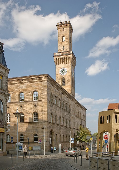
The Rathaus (town hall), built in the Italian style by Friedrich Bürklein between 1840 and 1850, is modelled on the Palazzo Vecchio in Florence. The "Glockenspiel" in the Rathaus is a mechanical music machine with 25 chromatically tuned cast bronze bells, similar to a carillon. It became nationally known through the daily playing of the rock classic "Stairway to Heaven" by the British rock group Led Zeppelin at 12:04 pm.
Museums
The Jewish Museum in Franconia' (Königstraße 89), which also has a branch in Schnaittach, was opened in 1999. The main part of the house goes back to the 17th century; Jewish families lived here until the late 19th century. The stucco ceilings, a historic Sukkah and a Mikvah in the basement have remained intact. The museum is also meant to be a meeting place, and has a bookshop and a cafeteria.
Stadtmuseum (Municipal/Town Museum), (Ottostr.2) at former Otto schoolhouse shows a lot of town history in a permanent exhibition and alternating special exhibitions
Sport and leisure
Sport
In the sporting world, Fürth came to fame through its football club SpVgg Fürth, which was German football champion three times. Since merging with the football section of TSV Vestenbergsgreuth the club is now called SpVgg Greuther Fürth. After winning the 2nd Bundesliga in 2011-12, the team moved up to the top level Bundesliga for the first time. The football stadium is in Ronhof (Stadion am Laubenweg).
The baseball team Fürth Pirates was promoted to the premier national baseball league in 2002 and became vice-champion in the 2004 season.
Each August, Fürth plays host to the annual Paul Hunter Classic, which is now a pro-am minor ranking snooker event and part of the European Players Tour Championship.
Leisure
The largest public barbecue area within Fürth is on the Rednitz, near the railway line to Würzburg and the swimming pool. It is shaded by trees and has barbecue facilities and fixed seating. Here you can also enjoy the area of Uferpromenade, where you can stroll or cycle along the riverside of Rednitz.
There are minigolf courses in the Stadtpark, by the Rhine-Main-Danube Canal, near Burgfarrnbach, and by the Pegnitz, a little upstream from the confluence with the Rednitz and near the municipal cemetery.
Kaynak: Wikipedia – Fürth · CC BY-SA 4.0