

Municipio de Apaseo el Grande
El municipio de Apaseo el Grande es uno de los 46 municipios del estado mexicano de Guanajuato.
Government administration · Mexico · 0 followers
Overview
El municipio de Apaseo el Grande es uno de los 46 municipios del estado mexicano de Guanajuato. Su cabecera es la localidad de Apaseo el Grande.
Interested in working with us in the future?
Follow to see new jobs and posts in your feed.
No news yet.
About

El municipio de Apaseo el Grande es uno de los 46 municipios del estado mexicano de Guanajuato. Su cabecera es la localidad de Apaseo el Grande.
Kaynak: Wikipedia · CC BY-SA 4.0
Geografía
El municipio de Apaseo el Grande se ubica al oriente del estado de Guanajuato. Limita al norte con los municipios de Comonfort y San Miguel de Allende, al sur con el municipio de Apaseo el Alto, al oeste con el municipio de Celaya y al este con el estado de Querétaro. La temperatura promedio es de 14 a 20 grados y la precipitación anual promedio es de 500 a 800 milímetros de lluvia. Pertenece a la región hidrológica del río Lerma-Santiago.
Demografía
En el censo de 2020 el municipio estaba poblado por 117 883 habitantes.
Localidades
En el censo de 2020 el municipio de Apaseo el Grande contaba con 128 localidades.
Economía

Sector Primario
El Municipio de Apaseo el Grande fue tradicionalmente un centro agrícola y ganadero, su agricultura se vio beneficiada de la construcción del distrito de riego del Alto Lerma. Se cultiva principalmente alfalfa, frijol (judía), maíz, pastos y sorgo. Sus habitantes también crían ganado bovino, porcino y caprino, destacando sobre las demás la cría de gallináceas. Estas actividades han visto reducido su contribución al porcentaje del PIB municipal en los últimos años debido al desarrollo de varias zonas industriales en el municipio. El porcentaje de contribución del Sector Primario a la Producción Bruta Total (PBT) era de apenas 0.1%, siendo un valor menor que el estatal de 0.32%. Esta desproporción se puede explicar por la actividad industrial de gran tamaño.
Sector secundario
En el año 2009, el porcentaje de contribución del Sector Secundario o Industrial a la Producción Bruta Total (PBT) era de 91.8%, siendo un valor superior al estatal de 74.1%.
El tipo de industria del municipio así como su número se distingue como sigue (INEGI):
Generación, transmisión y distribución de energía eléctrica, suministro de agua y de gas por ductos al consumidor final (1)
El 30 de junio de 2008, el gobernador del estado Juan Manuel Oliva Ramírez anunció la construcción del parque industrial La Amistad y El Porvenir dentro de la reserva territorial del municipio, como parte del plan de Metropolización de la Región Laja-Bajío. Entre las empresas ahí instaladas se encuentran Yachiyo, Yorozu, Yutaka, G-one, Tachi-s y NKP M, todas proveedoras de autopartes de Honda ubicada en el municipio de Celaya.
Procter & Gamble y Condumex son otras de las industrias ya establecidas desde hace años, la primera instalada en la comunidad de Caleras de Amexhe y la segunda en cabecera municipal.
Apaseo el Grande ocupa un lugar sobresaliente como municipio exportador en el Estado de Guanajuato pues en el 2011 ocupó el tercer lugar sólo detrás de Silao e Irapuato. La gran mayoría de estas exportaciones son producidas en Procter & Gamble y se dirigen hacia Estados Unidos y América Latina.
Kaynak: Wikipedia – Municipio de Apaseo el Grande · CC BY-SA 4.0
Etymology
The initial name of the town and municipality was Apatzeo, first used by Hernán Pérez de Bocanegra y Córdoba, who was apparently influenced by the expression in the Purépecha language meaning "place of weasels".
Other names of the city of Apaseo el Grande were Andehe (in the Otomi language) which appears in an inscription that is in the choir of the parish church and means "by the water". Another name, used by the viceroy Antonio de Mendoza, was Atlayahualco, from the Nahuatl language, meaning "by the lake".
On February 22, 1957, the Legislature of the State of Guanajuato ordered the publication in the Official Gazette of the State of Guanajuato, Decree Number 64, by which the city and the municipality of Apaseo took the nickname 'Apaseo el Grande' ("greater" or "larger"). This change was intended to resolve conflicts caused by the use of the nickname 'Apaseo el Bajo' ("Lower Apaseo") by residents of the smaller neighboring town of Apaseo el Alto ("Upper Apaseo").
History

The location of Apaseo el Grande – probably along with other towns in the region such as Izcuinapan (San Miguel Viejo, near San Miguel de Allende) and Tlachco (the present city of Querétaro) – was inhabited by various indigenous groups of Nahuatl, Otomi and Guamar peoples from ancient times and as a place of refuge following the Spanish conquest of Mexico.
Spanish colonization
The territory was conquered by Nuño Beltrán de Guzmán c. 1530, but its formal incorporation into the Spanish empire did not occur until 1538, by act of congregation of Indian villages issued by Viceroy Antonio de Mendoza. In 1537, Don Hernán Pérez de Bocanegra began buying properties from Don Fernando P. Motoci, lord of Xuaxo, and on October 11, 1564, entailed these under the mayorazgo system so the properties would be passed down in his family via primogeniture. This area became eastern Bajío, the name by which Spaniards, Creoles, Mestizos, Indians, blacks and mulattos called the property belonging to the principal landowner of the region.
By 1571, Apaseo had 50 Spanish families, 200 blacks, 150 mulattos, and 240 Otomi Indians who also spoke Nahuatl.
In 1547, silver deposits discovered in Zacatecas resulted in a steady stream of migration to the region, seen by the semi-nomadic Chichimecas as intrusions on their ancestral lands. Underpaid Spanish soldiers raided native villages to acquire slaves for the mines, and the Chichimicas made attacks against herders and traders on the border. Led by Bocanegra, the village of Apaseo defended itself against the Chichimecas, and the nearby town of Celaya was founded to bolster the region's defence. As the costly Chichimeca War entered its fourth decade, the colonial authorities reversed their aggressive treatment of the Chichimeca and introduced the "peace by purchase" policy, countering the insurgency by rewarding peaceful behavior while taking steps to settle them in villages and assimilate them.
Government and politics
The 2012 Mayoral elections were won by Mr. Lorenzo Licea Rojas from the Institutional Revolutionary Party (PRI) in alliance with the Green Party (PVEM). The opposition is formed by the National Action Party (PAN) and Party of the Democratic Revolution (PRD). The H. City Council was formed as follows.
The Municipality is organized into 49 communities, represented by elected delegates.
The Federal Deputy of District XIV is José Luis Oliveros Usabiaga and the local representative is Martin Lopez Camacho, both of the PAN.
Geography

The city of Apaseo el Grande is the capital of the municipality of the same name in the state of Guanajuato. The municipality is bordered on the north by the municipalities of Comonfort and San Miguel de Allende; to the east by the state of Querétaro; to the south by the municipality of Apaseo el Alto; and to the west by Celaya.
The city is located at an altitude of 1,767 metres (5,797 ft) on the margins of the watercourse of the Querétaro river, a tributary of the Laja River which flows into the Lerma River. Apaseo el Grande extends over an area of 415.26 km2 (160.33 sq mi), or 1.37% of the total area of the state. It ranks 20th of 46 municipalities in Guanajuato according to its 2010 Urbanization Index value of 0.59, much lower than the state level of 25.7.
Topography
The Sierra de los Agustinos range enters the town from the south, and the Sierra Codornices from the west. The highest elevations are found in the hills (Spanish: cerros) of Santa Rosa, Pelon, El Picacho, Peña, Ojo de Agua, El Tejocote, El Cohetero, La Huerta, Jalpa, Galvanes, Mayorazgo, and Vicar Estancia de las Vacas. Their average height is 2,000 metres (6,600 ft) above sea level. The highest point of the municipality is 2,598 metres (8,524 ft), at Cerro de La Rosa, on the municipality's border with Celaya to the north.
Hydrography
The main body of water is the Apaseo River, a tributary of the Laja River. In Querétaro, it forms currents and rivers like Huipal, from the state of Querétaro, that enters streams to the municipality of San Bartolo and Ixtla and the river Apaseo el Alto. There are two springs of sulphurous water, namely the Marroquín and the Mandujano. The town also has three alkaline water springs: El Nacimiento, Agua Tibia and Llanitos. The waters of Cañada Mandujano Cedazo and Ojos de Apaseo el Alto, gathered into streams, are used to irrigate the valley lands.
Demographics
Based on the 2010 Census of Population and Housing conducted by the National Institute of Statistics and Geography (INEGI), the city of Apaseo el Grande has 85,319 inhabitants of whom 41,038 are men and 44,281 are women, and 28.3% of the population is under 30. An increase in population in the coming years is expected due to the construction of housing projects in the outskirts of the metropolitan area of Querétaro, within the municipality of Apaseo el Grande.
Education
The Township of Apaseo el Grande offered 13 degree programs in 2010. 6.5% of the population 25 years and older have higher education (technical or commercial studies, completed high school, undergraduate, masters and/or PhD).
Religion
94.4% of the population identifies as Catholic. Since 1980, evangelical and Pentecostal groups entered into the communities, accounting for 2.5% of the population.
Migration
Apaseenses' emigration to the United States is primarily to cities in Texas, especially Dallas, possibly because of family ties and support to aid with employment prospects. North Carolina is also a common destination. The municipality ranks 26th in Guanajuato in migration levels.
Economy

The Municipality of Apaseo el Grande was traditionally an agricultural and livestock center. Agriculture benefited from the construction of the irrigation district of the Upper Lerma. The main crops are alfalfa, beans, corn, grasses and sorghum. Cattle, pigs and goats are raised, and fowl are bred. These activities have been reduced as a percentage of the economy in recent years due to the development of several industrial zones in the township. Though industry thrives in Apaseo el Grande, its production services gross total (PBT) is 8.1%, well below the 25.1% statewide total.
Apaseo el Grande occupies a prominent place in the state of Guanajuato for exporting. In 2011, it ranked third in the state, behind only Silao and Irapuato. The majority of these exports are produced by Procter & Gamble, and are shipped to the United States and Latin America.
Apaseo el Grande ranks 6 out of 46 municipalities in per capita PBT, 123,697, well above the state value of 80,315. But this wealth is poorly distributed among the population, with 56% of the population considered to be living in poverty.
Culture and tourism

Palacio de Herrera
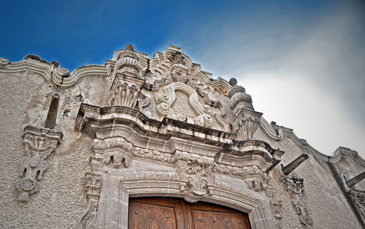
The Palace of Herrera (commonly called "Casa de los Perros" or the House of Dogs) is a prominent eighteenth-century colonial building. Constructed in a sober baroque style, this palace was commissioned by Don Francisco Fernández de Herrera y Antonio Merino Areávalo, landowner and merchant. Maximilian I stayed here while touring the Bajío. It is privately owned, with no public access.
Hacienda El Tunal
Fernández de Herrera owned several farms and ranches, some of which remained in the family for generations, as was the case for the Hacienda El Tunal. The hacienda was renovated in the latter nineteenth century, so it no longer represents the style of eighteenth century Bajío architecture. Access is restricted.
Temple and Franciscan Convent
This old set of buildings dates to the sixteenth century. The exterior of the church and its convent are in a military monastic style and the interior of the temple is neoclassical. Several chapels are attached to the temple with an open atrium.
Hacienda El Vicario
The Vicar appears to be a single piece from the outside. It is rumored that in 1814, the royalist army stationed soldiers on the estates of Apaseo, including El Vicario.
Railway station
This was one of the main stations of Guanajuato state for a quarter of exports, including agricultural products. The train was also used for transportation to border cities until the late-twentieth century. It is now in disrepair with no public access.
Hacienda La Labor
Erected in the late-eighteenth century by José Ignacio Villaseñor Cervantes, this hacienda retains the outlines of its facade with neoclassical alterations. It is reminiscent of Renaissance villas with a gallery of arches on columns, a tradition dating to the Conquista.
Hacienda de Obrajuelo
Another hacienda that retains historic elements, this belonged to Captain Fausto Merino from the mid-18th century. He donated it to the congregation of clerics of Our Lady of Guadalupe de Querétaro. In the mid-19th century, Maximilian I presented it, with the Buenavista Palace of Mexico City, to Marshal Bazaine as a dowry for his marriage.
Kaynak: Wikipedia – Apaseo el Grande · CC BY-SA 4.0