

Newton
Newton es una ciudad ubicada en el condado de Middlesex, en el estado estadounidense de Massachusetts.
Government administration · United States · 0 followers
Overview
Newton es una ciudad ubicada en el condado de Middlesex, en el estado estadounidense de Massachusetts. En el Censo de 2020 tenía una población de 88 923 habitantes y una densidad poblacional de 1.914,82 personas por km².
Interested in working with us in the future?
Follow to see new jobs and posts in your feed.
No news yet.
About

Newton es una ciudad ubicada en el condado de Middlesex, en el estado estadounidense de Massachusetts. En el Censo de 2020 tenía una población de 88 923 habitantes y una densidad poblacional de 1.914,82 personas por km².
Kaynak: Wikipedia · CC BY-SA 4.0
Geografía
Newton se encuentra ubicada en las coordenadas 42°19′55″N 71°12′30″O. Según la Oficina del Censo de los Estados Unidos, Newton tiene una superficie total de 47.04 km², de la cual 46.2 km² corresponden a tierra firme y (1.8 %) 0.85 km² es agua.
Demografía
Según el censo de 2010, había 85 146 personas residiendo en Newton. La densidad de población era de 1.809,9 hab./km². De los 85 146 habitantes, Newton estaba compuesto por el 82.3 % blancos, el 2.54 % eran afroamericanos, el 0.11 % eran amerindios, el 11.5 % eran asiáticos, el 0.02 % eran isleños del Pacífico, el 1.18 % eran de otras razas y el 2.36 % pertenecían a dos o más razas. Del total de la población el 4.08 % eran hispanos o latinos de cualquier raza.
History

17th century
Newton was originally part of "the newe towne", which was settled in 1630 and renamed Cambridge in 1638. The first English settlement of what is now Newton began in 1639. Roxbury minister John Eliot persuaded the Native American people of Nonantum, a sub-tribe of the Massachusett led by a sachem named Waban, to relocate to Natick in 1651, fearing that they would be exploited by colonists. Newton was incorporated as a separate town, known as Cambridge Village, on December 15, 1681, then renamed Newtown in 1691, and finally Newton in 1766. It became a city on January 5, 1874. Newton is known as The Garden City.
In the early 1600s, Watertown had claimed a large area of land on the south side of the Charles River (modern-day Newton). They gave it up to Newtown, except for a strip "two hundred rods long and sixty rods wide" to "protect their fishing privileges".
18th century
In Reflections in Bullough's Pond, Newton historian Diana Muir describes the early industries that developed in the late 18th and early 19th centuries in a series of mills built to take advantage of the water power available at Newton Upper Falls and Newton Lower Falls. Snuff, chocolate, glue, paper and other products were produced in these small mills but, according to Muir, the water power available in Newton was not sufficient to turn Newton into a manufacturing city, although it was, beginning in 1902, the home of the Stanley Motor Carriage Company, the maker of the Stanley Steamer.
19th century
Nineteenth-century Newton, following the American Civil War, was a patchwork of villages. The northern villages of Auburndale, Newton Corner, Newtonville, and West Newton were the most affluent. In contrast, both Waban and Chestnut Hill were sparsely populated.
Several village-based "improvement societies" were founded by residents between 1878 and 1904. No citywide improvement society was ever founded.
Geography

Newton is a suburban city approximately 7 mi (11 km) from downtown Boston, in Middlesex County. It is also bordered by Waltham and Watertown on the north, Needham and the West Roxbury neighborhood of Boston on the south, Wellesley and Weston on the west, and Brookline and the Brighton neighborhood of Boston on the east.
The Charles River flows along the north and west parts of Newton, and Route 128 passes through the western part of the city.
The Mass Pike passes through the more urbanized northern section of the city before heading into Boston. Additional major highways in Newton include Route 9, serving the southern parts of the city, and Hammond Pond Parkway, which is the main north–south route through Chestnut Hill and provides access to Brookline and West Roxbury.
According to the United States Census Bureau, the city has a total area of 18.2 square miles (47.1 km2), of which 18.0 square miles (46.6 km2) is land and 0.2 square miles (0.5 km2) (0.82%) is water.
Geological history
Geologically Newton is located within the topographic lowland of the Boston Basin of the Appalachian Mountain chain. This lowland is surrounded by a ring of highland drumlins which were left after the last glaciation twelve thousand years ago.
There are several unique outcroppings of rocks around Newton where geologic history revealing of how territory have formed and has changed over the past hundreds millions of years of drift supercontinents and ancient oceans, earthquake activity associated with volcanism and related faulting activity and changing climate. There are mainly three types of bedrock: Roxbury Conglomerate, Cambridge Argillite or Slate, and Brighton Volcanics and the Mattapan Volcanics pre-Cambrian foundation of Dedham Granodiorite. The Boston Border Fault and the Shawmut anticline of Newton formed as the alpine mountains of east-central Massachusetts were created. Unique outcroppings rocks exposure has steadily declined as Newton area has become increasingly developed.
Demographics
2020 census
As of the 2020 census, Newton had a population of 88,923. The median age was 41.7 years. 21.1% of residents were under the age of 18 and 19.5% of residents were 65 years of age or older. For every 100 females there were 90.9 males, and for every 100 females age 18 and over there were 87.7 males age 18 and over.
100.0% of residents lived in urban areas, while 0.0% lived in rural areas.
There were 31,704 households in Newton, of which 33.3% had children under the age of 18 living in them. Of all households, 58.7% were married-couple households, 12.5% were households with a male householder and no spouse or partner present, and 24.7% were households with a female householder and no spouse or partner present. About 23.6% of all households were made up of individuals and 12.6% had someone living alone who was 65 years of age or older.
There were 33,320 housing units, of which 4.8% were vacant. The homeowner vacancy rate was 0.8% and the rental vacancy rate was 5.1%.
2010 census
As of the census of 2010, there were 85,146 people, 32,648 households, and 20,499 families residing in the city. The population density was 4,643.6 inhabitants per square mile (1,792.9/km2). There were 32,112 housing units at an average density of 1,778.8 per square mile (686.8/km2). The racial makeup of the city was 79.6% White, 11.5% Asian, 2.5% African American, 0.07% Native American, 0.03% Pacific Islander, 0.71% from other races, and 1.46% from two or more races. Hispanic or Latino residents of any race were 4.1% of the population (0.7% Puerto Rican, 0.6% Mexican, 0.4% Colombian, 0.3% Guatemalan, 0.3% Argentine). (2010 Census Report: Census report Quickfacts.com)
Other demographics
Newton, along with neighboring Brookline, is known for its significant Jewish and Asian (practicing Christian or other) populations. The Jewish population as of 2002 was estimated to be 28,002.
Economy
Newton's largest employers include Boston College and Newton-Wellesley Hospital. Companies based in Newton include TechTarget, CyberArk, Upromise and Kanda Software.
Income
Data is from the 2009–2013 American Community Survey 5-Year Estimates.
Arts and culture

The city is home to two symphony orchestras, the New Philharmonia Orchestra of Massachusetts and the Newton Symphony Orchestra. The Joanne Langione Dance Center, an American youth dance school was founded in 1976.
Points of interest
Crystal Lake is a 33-acre (13 ha) natural lake located in Newton Centre. Its shores, mostly lined with private homes, also host two small parks, a designated swimming area, and a bathhouse. Previously known as Wiswall's Pond, it became known as Crystal Lake sometime between 1855 and 1875. The name was given by a nineteenth-century commercial ice harvester that sold ice cut from the pond in winter.
The Jackson Homestead, now the Newton History Museum at the Jackson Homestead, is best known for its history as a stop on the Underground Railroad. It was built in 1809 as a farmhouse designed in the Federal style, and is now a museum with paintings, costumes, photographs, manuscripts, maps and historical artifacts.
Heartbreak Hill, notably challenging stretch of the Boston Marathon, on Commonwealth Avenue between Walnut Street and Boston College.
Newton is home to many exclusive golf courses such as Woodland Country Club, Charles River Country Club, and Brae Burn Country Club, which held the United States Open in 1919.
City Stable and Garage, historic building
The John A. Fenno House is a historic house at 171 Lowell Avenue, built c. 1854, and a rare local example of Gothic Revival styling.
The House at 173–175 Ward Street is one of the city's few Federal style houses, built c. 1800
Echo Bridge is a notable 19th-century masonry arch bridge with views of the river and Hemlock Gorge in Hemlock Gorge Reservation just off Route 9 in Newton Upper Falls.
Norumbega Park was located in Auburndale on the Charles River. Opening in 1897 as a trolley park, it was a popular amusement park through the 1950s before closing in 1963. Its Totem Pole Ballroom became a well-known dancing and entertainment venue for big bands touring during the 1940s as well as other famous performers such as Doris Day, Bing Crosby, Eydie Gorme and The Four Lads. The park is now a popular dog-walking site with hills, meadows, woods, and access to the river.
Government

City
Newton has an elected strong mayor-council form of government. The council is called the City Council. The mayor is Marc Laredo.
Mayor: Marc Laredo, the city's chief executive officer and appoints the Chief Administrative Officer.
The City Council, Newton's legislative branch of municipal government, is made up of 24 members – sixteen Councilors-at-large and eight Ward Councilors. Councilors are elected every two years.
As of January 2026, the makeup of the City Council is:
Newton's school committee decides policies and budget for Newton Public Schools. It has nine voting members, consisting of the Mayor of Newton and eight at-large Ward representatives, who are elected.
County
Mismanagement of Middlesex County's public hospital in the mid-1990s left the county on the brink of insolvency, and in 1997 the Massachusetts legislature stepped in by assuming all assets and obligations of the county. The government of Middlesex County was officially abolished on July 11, 1997. The sheriff and some other regional officials with specific duties are still elected locally to perform duties within the county region, but there is no county council or commission. However, communities are now granted the right to form their own regional compacts for sharing services.
These are the remaining elected officers for Middlesex County:
Register of Probate: Tara E. DeCristofaro
State
John J. Lawn, Democrat of Watertown: Tenth Middlesex District, includes Precincts 1 and 4 of Ward 1, Newton.
Kay Khan, Democrat of Newton: Eleventh Middlesex District, includes precincts 2 and 3 of Ward 1, All precincts in Wards 2, 3 and 4 and precinct 2 of Ward 7, Newton.
Amy Mah Sangiolo, Democrat of Newton: Twelfth Middlesex District, includes all precincts in Wards 5 and 6, precincts 1, 3 and 4 of Ward 7; and all precincts in Ward 8, Newton.
Education

Public schools
Public education is provided by Newton Public Schools.
Higher education
Colleges and universities located in Newton include:
Boston College Law School in Newton Centre
Mount Ida Campus of UMass Amherst in Oak Hill, formerly the site of Mount Ida College
William James College in Oak Hill, formerly Massachusetts School of Professional Psychology
Newton Junior College
Newton Junior College, operated by the Newton Public Schools, opened in 1946 to serve the needs of returning veterans who otherwise would not have been able to continue their education due to the overcrowding of colleges and universities at that time. It used the facilities of Newton High School (now Newton North High School) until its own adjacent campus was built. It closed in 1976 due to declining enrollment and increased costs. The availability of such places as UMass Boston contributed to its demise. According to the city, its former campus is now "Claflin Park," a 25-unit multi-family development.
Others
Other former colleges include Aquinas College (1961–1999), Mount Alvernia College (1959–1973), Mount Ida College (1899–2018), and Newton College of the Sacred Heart (1946–1975). Andover Newton Theological School relocated to New Haven, Connecticut (1807–2017).
Media
News
The city's community newspaper The Newton TAB, a weekly print paper published by the Community Newspaper Company, and owned by Gatehouse Media, ceased print publication in May 2022. The Newton Patch covers daily local news out of Newton and offers a platform for locals to post opinion, events, news tips and blogs on the community online platform as well. The Newton Voice. The Newton community is also served by its high school publications, including Newton North High School's Newtonite and Newton South High School's Lion's Roar and Denebola. Fig City News is a free, online community news resource founded by resident volunteers to cover local news and community events in Newton. The Boston Globe occasionally covers Newton.
Television
Residents of Newton have access to a state-of-the-art television studio and community media center, NewTV, located at 23 Needham Street in Newton Highlands. Newton is also home to NECN, a regional news network owned by NBC. In addition, Newton, bordering Brighton, a neighborhood of Boston has the WGBH Studios
Radio
From 1968 to 2017, the studios and transmitter of WNTN AM-1550 were on Rumford Avenue in Auburndale.
Infrastructure
Hospital
Newton-Wellesley Hospital, which is owned by Mass General Hospital, is located at 2014 Washington Street in Newton. U.S. News & World Report ranks the hospital 13th best in the Boston metro area.
Transportation
Newton is well-served by three modes of mass transit run by the MBTA: light rail, commuter rail, and bus service. The Green Line D branch, (also known as the Riverside branch) is a light rail line running through the center of the city that makes very frequent trips to downtown Boston, ranging from 10 to 30 minutes away, terminating in Newton Lower Falls. The Green Line B branch ends across from Boston College on Commonwealth Avenue, virtually at the border of Boston's Brighton neighborhood and the City of Newton (an area which encompasses an unincorporated suburban village referred to as Chestnut Hill). The MBTA Worcester commuter rail, serving the northern villages of Newton that are proximate to Waltham, offers less frequent service to Boston. It runs from every half-an-hour during peak times to every couple of hours otherwise. The northern villages are also served by frequent express buses that go to downtown Boston via the Massachusetts Turnpike as well as Waltham.
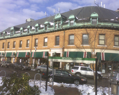
Newton Centre, which is centered around the MBTA station of the same name, has been lauded as an example of transit-oriented development.
The Massachusetts Turnpike (Interstate 90), which basically follows the old Boston and Albany Railroad main line right-of-way, runs east and west through Newton, while Route 128 (Interstate 95) slices through the extreme western part of the city in the Lower Falls area. Route 30 (Commonwealth Avenue), Route 16 (Watertown Street west to West Newton, where it follows Washington Street west) and route 9 (Worcester Turnpike or Boylston Street) also run east and west through the city. Another major Boston (and Brookline) street, Beacon Street, runs west from the Boston city line to Washington Street west of the hospital, where it terminates at Washington Street.
Cemeteries
East Parish Burying Ground, called Centre Street Cemetery by the city, dates from 1664
West Parish Burying Ground (River Street Cemetery), West Newton, public
St. Mary's Episcopal Church and Cemetery, 258 Concord Avenue, Newton Lower Falls, private
South Burying Ground called Winchester Street Cemetery or Evergreen Cemetery by the city, public
Newton Cemetery & Arboretum, Newton Center, private
In popular culture
The Fig Newton cookie is named after the city. In 1991, Newton and Nabisco hosted a celebration of the 100th anniversary of the Fig Newton. A 100-inch (250 cm) Fig Newton was served, and singer and guitarist Juice Newton performed.
Several scenes from the 1994 film The Next Karate Kid were filmed in Newton, including the house of the protagonist, who was played by Hilary Swank.
William Landay's 2012 crime-drama novel Defending Jacob is set in Newton. The web television miniseries adaptation of the novel, starring Chris Evans as main character Andy Barber, was filmed in various locations of the city
A portion of crime drama film Patriots Day, based on the events of the Boston Marathon bombing, was filmed at Lasell University (then Lasell College) in Newton on May 18, 2016.
Principal photography of the comedy film Sex Tape, starring Cameron Diaz and Jason Segel, took place in Newton on September 12, 2013.
A scene from the 2008 remake of The Women was filmed on the banks of Bulloughs Pond. The setting was used as the backdrop of a New York suburban town.
One of the main plot lines from the American spy drama series The Americans episode "Dyatkovo" is set in Newton. In the episode, Philip and Elizabeth are assigned to travel to Newton, where they must investigate Natalie Granholm, a woman suspected of being a Nazi collaborator, Anna Prokopchuk, that was involved in executions at Dyatkovo during World War II.