
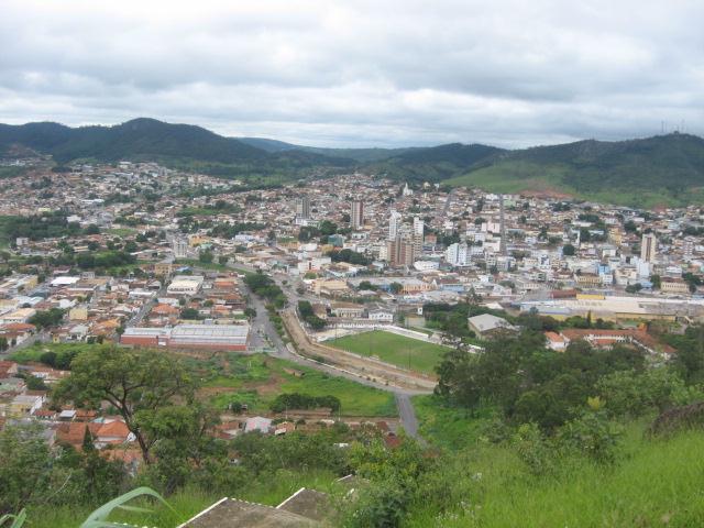

Pará de Minas
Pará de Minas é um município brasileiro no estado de Minas Gerais, Região Sudeste do país.
Government administration · Brazil · 0 followers
Overview
Pará de Minas é um município brasileiro no estado de Minas Gerais, Região Sudeste do país. Pertence ao colar metropolitano de Belo Horizonte, estando situado a cerca de 80 km a oeste da capital estadual. A cidade está localizada na região Central do estado e ocupa uma área de aproximadamente 550 km², sendo que 26 km² estão em área urbana, e sua população foi estimada em 102 844 habitantes em 2025.
Interested in working with us in the future?
Follow to see new jobs and posts in your feed.
No news yet.
About

Pará de Minas é um município brasileiro no estado de Minas Gerais, Região Sudeste do país. Pertence ao colar metropolitano de Belo Horizonte, estando situado a cerca de 80 km a oeste da capital estadual. A cidade está localizada na região Central do estado e ocupa uma área de aproximadamente 550 km², sendo que 26 km² estão em área urbana, e sua população foi estimada em 102 844 habitantes em 2025.
Kaynak: Wikipedia · CC BY-SA 4.0
História

Origens e pioneirismo
Até a chegada dos primeiros exploradores de origem europeia, a maior parte do território do atual estado de Minas Gerais era habitado por povos falantes de línguas do tronco macro-jê. A área do atual município de Pará de Minas teria sido visitada por volta de 1555, por bandeiras oriundas da Bahia, no entanto somente ao final do século XVII é que a exploração do local tem início de fato, por bandeirantes paulistas que exploravam o interior mineiro à procura de ouro e nativos para serem escravizados. Dentre as bandeiras que estiveram presentes na localidade, destacaram-se as de Fernão Dias Pais e Borba Gato, que vieram abrindo caminho pelo rio Pará.
A descoberta de ouro em Pitangui fez com que uma estrada fosse aberta ligando as minas ao território paulista. Às margens do ribeirão Paciência, foi organizado um ponto de repouso para os viajantes, no entanto a fertilidade das terras fez alguns se afixarem e darem início a um pequeno povoamento. Em 1710, Borba Gato recebeu de Antônio de Albuquerque Coelho de Carvalho, governador da então Capitania de São Paulo e Minas do Ouro, boa parte das terras, onde foram instaladas sesmarias. Manuel Batista, apelidado de Pato Fofo, foi o responsável por erguer uma capela dedicada a Nossa Senhora da Piedade, instituída a 2 de julho de 1772. Por causa de seu apelido, o lugar passou a se chamar Arraial do Patafofo.
A importância econômica da localidade resumia-se inicialmente ao comércio de abastecimento de bandeiras que se dirigiam às minas de Pitangui e o surgimento do arraial esteve diretamente ligado ao mercado consumidor para os produtos agropecuários provenientes da cidade vizinha. Até o início do século XIX, o vilarejo era composto basicamente por fazendas de mercadorias, com grande parte da estrutura econômica baseada na produção de derivados da cana-de-açúcar, e se observa o estabelecimento e pequenas indústrias relacionadas ao setor têxtil. Em 1826, registrava-se um total de cerca de 1 646 residentes, ocasião em que é implantada a pecuária. Em 1860, um inventário apontava um total de 165 propriedades cadastradas, dentre as quais 36,94% registravam cultivo de gado bovino e em 36,39% havia criação de cavalos. Em janeiro de 1885, tem-se a inauguração do primeiro grande estabelecimento de saúde, o Hospital Nossa Senhora da Conceição do Pará, e em 1893, entrou em funcionamento o primeiro sistema de iluminação noturna, inicialmente à base de luz e lampião.
Geografia

A área do município, segundo o Instituto Brasileiro de Geografia e Estatística (IBGE), é de 551,247 km², sendo que 25,72 km² constituem a zona urbana. Situa-se a 19°51'37" de latitude sul e 44°36'30" de longitude oeste e está a uma distância de 80 quilômetros a oeste da capital mineira, fazendo parte do colar metropolitano de Belo Horizonte. Seus municípios limítrofes são São José da Varginha, a norte; Onça de Pitangui, a nordeste; Conceição do Pará, a leste; Igaratinga, a sudoeste; Mateus Leme e Itaúna, a sul; Florestal, a leste; e Esmeraldas, a nordeste.
De acordo com a divisão regional vigente desde 2017, instituída pelo IBGE, o município pertence às Regiões Geográficas Intermediária de Divinópolis e Imediata de Pará de Minas. Até então, com a vigência das divisões em microrregiões e mesorregiões, fazia parte da microrregião de Pará de Minas, que por sua vez estava incluída na mesorregião Metropolitana de Belo Horizonte.
Relevo, geomorfologia e hidrografia
O relevo do município de Pará de Minas é predominantemente sinuoso. Aproximadamente 60% do território paraminense é coberto por áreas onduladas, enquanto em cerca de 20% há o predomínio de terrenos montanhosos e os 20% restantes são lugares planos. A altitude máxima está situada na Serra da Piteira, que chega aos 1 196 metros, enquanto que a altitude mínima está na foz do ribeirão Paciência, com 772 metros, e o ponto central da cidade está a 791,93 metros. O solo é rico em agalmatolito, quartzito e sílex, com predomínio de rochas gnáissicas. Às margens dos rios, o relevo se mostra mais fortemente rejuvenescido, tendo presença de altas escarpas gnáissicas e pontões de rochas.
Ao longo da rede de drenagem, é marcante o padrão retangular e os cursos da água profundamente encaixados, características visíveis em fotografias aéreas. Os depósitos aluvionares são acentuadamente reposicionados e mais elevados em relação ao nível dos cursos hidrográficos. A maior parte do relevo montanhoso, por sua vez, está estruturado sobre quartzitos e hidrotermalitos resistentes ao intemperismo e corresponde às serras do Andaime e da Piteira. Nos topos aplainados das serras, nota-se um desenvolvimento de carapaças lateríticas consolidadas, de idade miocênica-pliocênica.
Demografia

Em 2022, a população foi estimada em 97 139 habitantes pelo censo daquele ano, realizado pelo Instituto Brasileiro de Geografia e Estatística (IBGE). Em 2010, a população era de 84 215 habitantes. Segundo o censo de 2010, 41 639 habitantes eram homens e 42 576 habitantes mulheres. Ainda segundo o mesmo censo, 79 599 habitantes viviam na zona urbana e 4 616 na zona rural.
Da população total em 2010, 18 870 habitantes (22,41%) tinham menos de 15 anos de idade, 59 259 habitantes (70,34%) tinham de 15 a 64 anos e 6 086 pessoas (7,23%) possuíam mais de 65 anos, sendo que a esperança de vida ao nascer era de 75,9 anos e a taxa de fecundidade total por mulher era de 1,6. O IBGE considera Pará de Minas como um centro de zona A, ou seja, a cidade exerce influência preponderante sobre as demais próximas; neste caso, sobre os municípios de Igaratinga, Maravilhas, Onça de Pitangui, Pequi e São José da Varginha.
Pobreza, desenvolvimento e desigualdade
De 2000 a 2010, a proporção de pessoas com renda domiciliar per capita de até meio salário mínimo reduziu em 70,6% e em 2010, 96% da população vivia acima da linha de pobreza, 3,3% encontrava-se na linha da pobreza e 0,7% estava abaixo e o coeficiente de Gini, que mede a desigualdade social, era de 0,435, sendo que 1,00 é o pior número e 0,00 é o melhor. A participação dos 20% da população mais rica da cidade no rendimento total municipal era de 49,5%, ou seja, 8,7 vezes superior à dos 20% mais pobres, que era de 5,7%. Segundo o IBGE, em 2010 o único aglomerado subnormal contido em Pará de Minas era a chamada Vila Nossa Senhora Aparecida, também conhecida como Morro Santa Cruz, que está situada na entrada da cidade, às margens da BR-262. A localidade contava com um total de 638 moradores distribuídos em 174 domicílios particulares permanentes.
O Índice de Desenvolvimento Humano Municipal (IDH-M) de Pará de Minas é considerado elevado pelo Programa das Nações Unidas para o Desenvolvimento (PNUD), sendo que seu valor é de 0,725 (o 1154º maior do Brasil). A cidade possui a maioria dos indicadores próximos ou mesmo acima da média nacional segundo o PNUD. Considerando-se apenas o índice de educação, o valor é de 0,628, o valor do índice de longevidade é de 0,848 e o de renda é de 0,715. A cidade ocupa a 45ª posição dentre as mais desenvolvidas do país, segundo a Fundação Getulio Vargas (FGV) em 2012, levando em consideração, além da educação, saúde e renda, a segurança.
Política e administração

A administração municipal se dá pelos Poderes Executivo e Legislativo. O Executivo é exercido pelo prefeito, auxiliado pelo seu gabinete de secretários. O atual prefeito é Inácio Franco, do Partido Liberal (2006) (PL), eleito nas eleições municipais de 2024 com 60,05% dos votos válidos e empossado em 1º de janeiro de 2025, ao lado de Luiz Lima como vice-prefeito. O Poder Legislativo, por sua vez, é constituído pela câmara municipal, composta por 17 vereadores. O atual Presidente da Câmara dos Vereadores é Délio Alves. Cabe à casa elaborar e votar leis fundamentais à administração e ao Executivo, especialmente o orçamento participativo (Lei de Diretrizes Orçamentárias). Dentre os naturais de Pará de Minas que se destacaram no cenário político estadual e mesmo nacional, cabe ser ressaltado Benedito Valadares, que ocupou os cargos de deputado federal, senador e governador de Minas Gerais.
Em complementação ao processo Legislativo e ao trabalho das secretarias, existem também conselhos municipais em atividade, entre os quais dos direitos da criança e do adolescente, criado em 1992, tutelar (2009), direitos do idoso (2004), da pessoa com deficiência (2011) e de políticas para mulheres (2010). Pará de Minas se rege por sua lei orgânica, que foi promulgada em 21 de março de 1990, e abriga uma comarca do Poder Judiciário estadual, de segunda entrância, tendo como termos os municípios de Florestal, Igaratinga, Onça de Pitangui, Pequi, São Gonçalo do Pará e São José da Varginha. O município possuía, em outubro de 2024, 67 600 eleitores, de acordo com o Tribunal Superior Eleitoral (TSE), o que representa 0,391% do eleitorado mineiro.
Economia

No Produto Interno Bruto (PIB) de Pará de Minas, destacam-se a agropecuária, associada ao agronegócio, e a área de prestação de serviços. De acordo com dados do IBGE, relativos a 2021, o PIB do município era de R$ 4 025 297,487 mil, sendo que em 2021 possuía o 31º maior PIB do estado. Em 2021, R$637,159,835 mil eram de impostos sobre produtos líquidos de subsídios a preços correntes e o PIB per capita era de R$ 42 098,58. Em 2010, 71,91% da população maior de 18 anos era economicamente ativa, enquanto que a taxa de desocupação era de 4,49%.
Salários juntamente com outras remunerações somavam 311 687 mil reais e o salário médio mensal de todo município era de 2,0 salários mínimos. Havia 3 047 unidades locais e 2 939 empresas atuantes. Segundo o IBGE, 55,49% das residências sobreviviam com menos de salário mínimo mensal por morador (14 138 domicílios), 35,90% sobreviviam com entre um e três salários mínimos para cada pessoa (9 141 domicílios), 4,48% recebiam entre três e cinco salários (1 142 domicílios), 2,83% tinham rendimento mensal acima de cinco salários mínimos (720 domicílios) e 1,31% não tinham rendimento (334 domicílios).
Setor primário
Em 2021, de todo o PIB da cidade, 128 982,28 mil reais era o valor adicionado bruto da agropecuária, enquanto que em 2010, 8,08% da população economicamente ativa do município estava ocupada no setor. Segundo o IBGE, em 2012 o município possuía um rebanho de 44 496 bovinos, 605 bubalinos, 14 asininos, 134 caprinos, 1 386 equinos, 117 muares, 242 ovinos, 123 958 suínos e 12 740 806 aves, entre estas 220 136 galinhas e 12 520 670 galos, frangos e pintinhos. Neste mesmo ano, a cidade produziu 19 189 mil litros de leite de 10 149 vacas e 2 750 mil dúzias de ovos de galinha. Pará de Minas é considerada como um pólo regional em relação à agricultura, suinocultura e avicultura e ocasionalmente, o Parque de Exposições Francisco Olivé Diniz recebe eventos de âmbito local ou mesmo estadual que visam a divulgar a produção, sendo o maior deles a Fest Frango (Feira Estadual do Frango e do Suíno). A pecuária está presente desde o século XIX e foi fortalecida no decorrer do século XX com o surgimento das primeiras agroindústrias e de cooperaticas. Após a década de 70, foi introduzida a avicultura e na década de 90, tem-se a chegada da suinocultura, tendo ambas ganhado impulso ao começo da década de 2000.
Infraestrutura

Saúde
Pará de Minas possuía, em 2009, 50 estabelecimentos de saúde, sendo 25 deles privados e 25 públicos municipais entre hospitais, pronto-socorros, postos de saúde e serviços odontológicos. Neles havia 121 leitos para internação. Em 2012, 98,9% das crianças menores de 1 ano de idade estavam com a carteira de vacinação em dia. Em 2011, foram registrados 1 109 nascidos vivos, ao mesmo tempo que o índice de mortalidade infantil foi de nove óbitos de crianças menores de cinco anos de idade a cada mil nascidos vivos. Em 2010, 5,43% das mulheres de 10 a 17 anos tiveram filhos, sendo 0,23% delas entre 10 e 14 anos e a taxa de atividade nesta faixa etária de 4,95%. 90,2% das crianças menores de 2 anos de idade foram pesadas pelo Programa Saúde da Família em 2012, sendo que 0,4% delas estava desnutrida.
Secretaria Municipal de Saúde é o órgão ligado de forma direta à prefeitura do município de Pará de Minas e tem por função a manutenção e funcionamento do Sistema Único de Saúde (SUS), assim como a criação de políticas, programas e projetos que visem à saúde municipal. Dentre os serviços de apoio e atenção básica são alguns: o Programa Saúde da Família (PSF), as Unidades Básicas de Saúde (UBS), as Unidades de Pronto Atendimento (UPAs) e o Serviço de Atendimento Móvel de Urgência (SAMU). Compõem ainda os serviços desenvolvidos pela prefeitura municipal o centro de zoonoses, responsável pelo controle de doenças transmitidas por animais, e a divisão de vigilância em saúde composta pelas seções de saúde epidemiológica e vigilância sanitária. O Hospital Nossa Senhora da Conceição de Pará de Minas é o mais antigo e principal hospital da cidade, tendo sido fundado em 1885, reconstruído em um novo prédio em 1915 e reinaugurado em 1929.
Educação
Na área da educação, o Índice de Desenvolvimento da Educação Básica (IDEB) médio entre as escolas públicas de Pará de Minas era, no ano de 2011, de 5,3 (numa escala de avaliação que vai de nota 1 à 10), sendo que a nota obtida por alunos do 5º ano (antiga 4ª série) foi de 6,4 e do 9º ano (antiga 8ª série) foi de 4,3; o valor das escolas públicas de todo o Brasil era de 4,0. Em 2010, 0,93% das crianças com faixa etária entre sete e quatorze anos não estavam cursando o ensino fundamental. A taxa de conclusão, entre jovens de 15 a 17 anos, era de 38,9% e o percentual de alfabetização de jovens e adolescentes entre 18 e 24 anos era de 99,2%. A distorção idade-série entre alunos do ensino fundamental, ou seja, com idade superior à recomendada, era de 6,7% para os anos iniciais e 27,6% nos anos finais e, no ensino médio, a defasagem chegava a 32,2%. Dentre os habitantes de 18 anos ou mais, 50,46% tinham completado o ensino fundamental e 31,78% o ensino médio, sendo que a população tinha em média 9,38 anos esperados de estudo.
Cultura

A responsável pelo setor cultural de Pará de Minas é a Secretaria Municipal de Cultura, SECULT, que tem como objetivo planejar e executar a política cultural do município por meio da elaboração de programas, projetos e atividades que visem ao desenvolvimento cultural. Subordinada à secretaria, atuam seus órgãos operacionais, dentre os quais cabem ser ressaltados a Biblioteca Pública Professor Melo Cançado, Escola Municipal de Artes e Ofícios Raimundo Nogueira de Faria (Sica), Escola Municipal de Música Geraldo Martins, o Arquivo Público Municipal Mário Luiz Silva e o Museu Histórico, Documental, Fotográfico e do Som de Pará de Minas (MUSPAM). A Secretaria Municipal de Esporte, Lazer e Turismo foi desmembrada da secretaria de cultura em 1º de abril de 2013, sendo encarregada de seus respectivos setores.
Dentre os artistas naturais de Pará de Minas, obtiveram destaque nacional ou mesmo internacional o compositor, cantor e ator Benjamin de Oliveira, conhecido por ser o primeiro palhaço negro do Brasil; o artista plástico, desenhista e vitralista Mário Silésio, que produziu diversos painéis em edifícios públicos de Belo Horizonte; e a atriz Cida Mendes, que se destacou ao interpretar a personagem Concessa no programa A Turma do Didi.
Artes cênicas e artesanato
Em 2002, o Governo Federal anunciou recursos para custear a construção de um teatro na cidade, que até então não possuía. O Teatro Municipal Geraldina Campos de Almeida foi inaugurado em 3 de dezembro de 2012, tendo uma ampla tecnologia de iluminação, dependências para deficientes físicos e contando com capacidade para 213 lugares, localizando-se atrás da Casa da Cultura. Esta, foi fundada na década de 1910 e até setembro de 2015 receberá investimentos na reforma do local e no acesso do Teatro Municipal.
O artesanato é uma das formas mais espontâneas da expressão cultural paraminense, sendo que, segundo o IBGE, as principais atividades artesanais desenvolvidas são o bordado e trabalhos produzidos com argila e fibras vegetais. A Escola Municipal de Artes e Ofícios (SICA) também é palco de exposições e ocasionalmente oferece à população, a partir dos 4 anos de idade, cursos e oficinas relacionados tanto às artes plásticas quanto cênicas e expressivas. A Escola Municipal de Música Geraldo Martins, também conhecida por Escola Geraldinho do Cavaquinho, como o próprio nome sugere, oferta formação musical e por vezes suas apresentações são abertas ao público. Ambas são mantidas em parceria direta com a Secretaria Municipal de Cultura e Educação. O acervo literário da Biblioteca Pública Municipal Professor Melo Cançado é o maior da cidade, tendo recebido 550 novos livros e materiais áudio-visuais em março de 2014.
Kaynak: Wikipedia – Pará de Minas · CC BY-SA 4.0
History
Origins
Before the arrival of the first European explorers, most of the territory of present-day Minas Gerais was inhabited by indigenous peoples speaking languages of the Macro-Jê linguistic family. The area of present-day Pará de Minas was likely visited around 1555 by expeditions from Bahia, but significant exploration only began in the late 17th century by Paulista bandeirantes searching for gold and indigenous people to enslave. Notable expeditions included those led by Fernão Dias Pais and Borba Gato, who opened paths along the Pará River.
The discovery of gold in Pitangui led to the opening of a road connecting the mines to São Paulo. Along the Paciência Stream, a rest stop was established for travelers, but the fertile lands prompted some to settle, forming a small community. In 1710, Borba Gato received a large portion of the land from Antônio de Albuquerque Coelho de Carvalho, governor of the then Captaincy of São Paulo and Minas de Ouro, where sesmarias were established. Manuel Batista, nicknamed Pato Fofo, built a chapel dedicated to Our Lady of Mercy, inaugurated on 2 July 1772. Due to his nickname, the place became known as Arraial do Patafofo.
Initially, the local economy revolved around supplying provisions to expeditions heading to the Pitangui mines, and the settlement's growth was tied to the consumer market for agricultural products from the neighboring city. Until the early 19th century, the village consisted mainly of farms producing goods, with much of the economy based on sugarcane derivatives, and small-scale textile industries began to emerge. By 1826, the population was approximately 1,646 residents, when livestock farming was introduced. In 1860, an inventory recorded 165 registered properties, with 36.94% engaged in cattle farming and 36.39% in horse breeding. In January 1885, the first major healthcare facility, the Nossa Senhora da Conceição do Pará Hospital, was inaugurated, and in 1893, the first nighttime lighting system, initially using lamps, was implemented.
Geography
According to the Brazilian Institute of Geography and Statistics (IBGE), the municipality's area is 551.247 km2 (212.838 sq mi), with 9.9387 km2 (3.8374 sq mi) in the urban area and the remaining 541.308 km2 (209.000 sq mi) in the rural area. It is located at 19°51'37" south latitude and 44°36'30" west longitude and is 86 km (53 mi) west of the state capital, forming part of the metropolitan belt of Belo Horizonte along with 16 other cities. Its neighboring municipalities are São José da Varginha to the north; Onça de Pitangui to the northeast; Conceição do Pará to the east; Igaratinga to the southwest; Mateus Leme and Itaúna to the south; Florestal to the east; and Esmeraldas to the northeast.
According to the regional division in effect since 2017, established by the IBGE, the municipality belongs to the Intermediate Geographic Region of Divinópolis and the Immediate Geographic Region of Pará de Minas. Previously, under the division into microregions and mesoregions, it was part of the Pará de Minas microregion, which was included in the Metropolitan mesoregion of Belo Horizonte.
Topography, geomorphology, and hydrography
The terrain of Pará de Minas is predominantly undulating. Approximately 60% of the municipal territory is covered by rolling hills, about 20% consists of mountainous terrain, and the remaining 20% is flat. The highest elevation is at Serra da Piteira, reaching 1,196 m (3,924 ft), while the lowest is at the mouth of the Paciência Stream, at 772 m (2,533 ft), with the city center at 791.93 m (2,598.2 ft). The soil is rich in agalmatolite, quartzite, and flint, with a predominance of gneiss rocks. Along the rivers, the terrain is more sharply rejuvenated, featuring high gneiss escarpments and rocky outcrops.
The drainage network displays a distinct rectangular pattern, with deeply incised watercourses, visible in aerial photographs. Alluvial deposits are significantly repositioned and elevated relative to the watercourses. The mountainous terrain is primarily composed of quartzites and hydrothermalites, which are resistant to weathering, corresponding to the Andaime and Piteira ridges. On the flattened ridge tops, consolidated laterite crusts of Miocene-Pliocene age are observed.
Demography
In 2010, the population of the municipality was recorded by the Brazilian Institute of Geography and Statistics (IBGE) as 84,215 inhabitants. According to the 2010 census, 41,639 inhabitants were male, and 42,576 were female. The same census reported 79,599 inhabitants living in the urban area and 4,616 in the rural area. According to the 2022 census, the municipal population was 97,139 inhabitants.
Of the total population in 2010, 18,870 inhabitants (22.41%) were under 15 years old, 59,259 inhabitants (70.34%) were aged 15 to 64, and 6,086 people (7.23%) were over 65, with a life expectancy at birth of 75.9 years and a total fertility rate of 1.6 children per woman. The IBGE classifies Pará de Minas as an A zone center, meaning the city exerts significant influence over nearby municipalities, including Igaratinga, Maravilhas, Onça de Pitangui, Pequi, and São José da Varginha.
Poverty, development, and inequality
From 2000 to 2010, the proportion of people with a per capita household income of up to half the minimum wage decreased by 70.6%. In 2010, 96% of the population lived above the poverty line, 3.3% were at the poverty line, and 0.7% were below it. The Gini coefficient, which measures social inequality, was 0.435, where 1.00 is the worst and 0.00 is the best. The wealthiest 20% of the population accounted for 49.5% of the city's total income, 8.7 times higher than the 5.7% share of the poorest 20%. According to the IBGE, in 2010, the only subnormal agglomeration in Pará de Minas was Vila Nossa Senhora Aparecida, also known as Morro Santa Cruz, located at the city's entrance along BR-262, with 638 residents in 174 permanent private households.
The Human Development Index (HDI-M) of Pará de Minas is considered high by the United Nations Development Programme (UNDP), with a value of 0.725 (the 1154th highest in Brazil). The city has most indicators at or above the national average, according to the UNDP. The education index is 0.628, the longevity index is 0.848, and the income index is 0.715. The city ranks 45th among the most developed municipalities in Brazil, according to the Getulio Vargas Foundation (FGV) in 2012, considering education, health, income, and safety.
Politics and administration
Municipal administration is carried out by the Executive and Legislative branches. The Executive is led by the mayor, supported by a cabinet of secretaries. The current mayor is Inácio Franco of the Liberal Party (PL), elected in the 2024 municipal elections with 60.05% of valid votes and sworn in on 1 January 2025, alongside Luiz Lima as vice-mayor. The Legislative branch consists of the municipal chamber, composed of 17 councilors. The current President of the Chamber of Councilors is Délio Alves. The chamber is responsible for drafting and voting on fundamental laws for administration and the Executive, particularly the participatory budget (Budget Guidelines Law). Among notable figures from Pará de Minas in state and national politics is Benedito Valadares, who served as a federal deputy, senator, and governor of Minas Gerais.
In addition to the Legislative process and the work of the secretariats, several municipal councils are active, including those for children's and adolescents' rights (created in 1992), guardianship (2009), elderly rights (2004), persons with disabilities (2011), and women's policies (2010). Pará de Minas is governed by its organic law, enacted on 21 March 1990, and hosts a comarca of the state judiciary, of second grade, covering the municipalities of Florestal, Igaratinga, Onça de Pitangui, Pequi, São Gonçalo do Pará, and São José da Varginha. As of October 2024, the municipality had 67,600 voters, according to the Superior Electoral Court (TSE), representing 0.391% of the Minas Gerais electorate.
Economy
In the Gross Domestic Product (GDP) of Pará de Minas, agriculture, linked to agribusiness, and the service sector stand out. According to 2021 IBGE data, the municipal GDP was R$4,025,297,487, ranking as the 31st largest GDP in the state. In 2021, R$637,159,835 were from taxes on products net of subsidies at current prices, and the per capita GDP was R$42,098.58. In 2010, 71.91% of the population over 18 was economically active, with an unemployment rate of 4.49%.
Wages and other remunerations totaled R$311,687,000, with an average monthly wage of 2.0 minimum wages. There were 3,047 local units and 2,939 active companies. According to the IBGE, 55.49% of households survived on less than one minimum wage per month per resident (14,138 households), 35.90% had one to three minimum wages per person (9,141 households), 4.48% earned three to five wages (1,142 households), 2.83% had incomes above five minimum wages (720 households), and 1.31% had no income (334 households).
Primary sector
In 2021, the gross value added from agriculture and livestock to the city's GDP was R$128,982,280. In 2010, 8.08% of the municipality's economically active population was employed in this sector. According to the Brazilian Institute of Geography and Statistics (IBGE), in 2012, the municipality had a livestock inventory consisting of 44,496 cattle, 605 buffalo, 14 donkeys, 134 goats, 1,386 horses, 117 mules, 242 sheep, 123,958 pigs, and 12,740,806 poultry, including 220,136 hens and 12,520,670 roosters, broilers, and chicks. In the same year, the city produced 19,189,000 litres of milk from 10,149 cows and 2,750,000 dozen eggs from hens. Pará de Minas is recognized as a regional hub for agriculture, pig farming, and poultry farming. Occasionally, the Francisco Olivé Diniz Exhibition Park hosts local and statewide events to promote agricultural production, with the largest being the Fest Frango (State Chicken and Pig Fair). Livestock farming has been a cornerstone of the local economy since the 19th century and gained prominence in the 20th century with the establishment of the first agro-industries and cooperatives. Poultry farming was introduced in the 1970s, followed by pig farming in the 1990s, both of which saw significant growth at the start of the 2000s.
Infrastructure
Healthcare
In 2009, Pará de Minas had 50 healthcare facilities, with 25 private and 25 municipal public institutions, including hospitals, emergency departments, health centers, and dentistry services. These facilities provided 121 hospitalization beds. In 2012, 98.9% of children under one year of age had up-to-date vaccination records. In 2011, 1,109 live births were recorded, with an infant mortality rate of nine deaths per 1,000 live births for children under five. In 2010, 5.43% of women aged 10 to 17 had children, with 0.23% of them aged 10 to 14, and the activity rate in this age group was 4.95%. In 2012, 90.2% of children under two were weighed by the Family Health Program, with 0.4% found to be malnourished.
The Municipal Health Department, directly linked to the city government, oversees the maintenance and operation of the Unified Health System (SUS) and develops policies, programs, and projects to promote municipal health. Key services include the Family Health Program (PSF), Primary Healthcare Units (UBS), Urgent Care Units (UPAs), and the Mobile Emergency Care Service (SAMU). Additional services include the zoonosis control center, responsible for managing animal-transmitted diseases, and the health surveillance division, which includes epidemiological and sanitary surveillance sections. The Our Lady of Conception Hospital, the city's oldest and main hospital, was founded in 1885, rebuilt in a new building in 1915, and reinaugurated in 1929.
Education
In education, the average Basic Education Development Index (IDEB) score for public schools in Pará de Minas in 2011 was 5.3 (on a scale from 1 to 10). Fifth-grade students scored 6.4, while ninth-grade students scored 4.3, compared to a national public school average of 4.0. In 2010, 0.93% of children aged 7 to 14 were not enrolled in primary education. The completion rate for youths aged 15 to 17 was 38.9%, and the literacy rate for youths and adolescents aged 18 to 24 was 99.2%. The age-grade distortion rate in primary education—students older than the recommended age—was 6.7% for early years and 27.6% for later years, while in secondary education, it reached 32.2%. Among residents aged 18 or older, 50.46% had completed primary education, 31.78% had completed secondary education, and the population had an average of 9.38 expected years of schooling.
Culture
The Municipal Department of Culture and Education oversees cultural activities in Pará de Minas, aiming to plan and implement cultural policies through programs, projects, and activities that promote cultural development. Subordinate to the department are operational bodies, including the Professor Melo Cançado Public Library, the Raimundo Nogueira de Faria Municipal Arts and Crafts School (Sica), the Geraldo Martins Municipal Music School, the Mário Luiz Silva Public Archive, and the Pará de Minas Historical, Documentary, Photographic, and Sound Museum (MUSPAM). The Municipal Department of Sports, Leisure, and Tourism was separated from the culture department on 1 April 2013, taking responsibility for those sectors.
Notable artists from Pará de Minas who have achieved national or international recognition include composer, singer, and actor Benjamin de Oliveira, known as Brazil's first Black clown; visual artist, illustrator, and stained glass artist Mário Silésio, who created numerous panels in public buildings in Belo Horizonte; and actress Cida Mendes, known for playing Concessa in the program A Turma do Didi.
Performing arts and crafts
In 2002, the federal government allocated funds to build a theater in the city, which previously lacked one. The Geraldina Campos de Almeida Municipal Theater was inaugurated on 3 December 2012, featuring advanced lighting technology, accessibility for people with disabilities, and a capacity of 213 seats, located behind the House of Culture. The House of Culture, established in the 1910s, is set to receive investments for renovations and improved theater access by September 2015.
Handicrafts are a vibrant form of cultural expression in Pará de Minas, with the main activities, according to IBGE, including embroidery, and works made from clay and vegetable fibers. The Municipal Arts and Crafts School (SICA) hosts exhibitions and offers courses and workshops in visual, performing, and expressive arts for residents aged four and up. The Geraldo Martins Municipal Music School, also known as Geraldinho do Cavaquinho School, provides musical training, with some performances open to the public. Both schools are maintained in partnership with the Municipal Department of Culture and Education. The Professor Melo Cançado Public Library holds the city’s largest literary collection, receiving 550 new books and audiovisual materials in March 2014.
Sports

The city is home to teams in various sports, which occasionally achieve prominence by winning regional, state, or even national titles, including basketball, handball, volleyball, and futsal. Extreme sports, such as skateboarding, BMX, and athletics, are also popular, particularly among the younger population. Bariri Park features a walking track, a skateboarding area, and multi-sport courts used for basketball, volleyball, beach volleyball, futsal, peteca, dodgeball, martial arts, and gymnastics. The Ovídio de Abreu Stadium is the main football stadium in Pará de Minas, with a capacity of approximately 1,500 people.
The most successful football team in the city is Paraense Esporte Clube, founded on 15 May 1936, which has competed in several editions of the Campeonato Mineiro, in both its main division and youth categories. Football has been a part of Pará de Minas since the early 20th century, when people played with makeshift balls made of socks in the streets. Later, workers responsible for the construction of the Paracatu Railway introduced leather balls for recreation. The Mello Sobrinho Foot-Ball Club, founded in 1923 and dissolved shortly after, was the city's first team, succeeded by the Americano Futebol Clube, which existed from 1924 to 1931 and paved the way for the establishment of other teams, particularly between the 1940s and 1960s. In 1976, the Pará de Minas Sports League was created to organize football championships and events in the city and region, with the Paraminense Amateur Football Championship held annually since 1977.
In 2011, plans were proposed for the construction of a training center for FC Porto in the city, supported by the state government for civil works, with renovations planned for the Ovídio de Abreu Stadium and completion expected by 2018, generating approximately 800 direct and indirect jobs. After several delays, earthworks began in September 2012 on a 980,000 m2 site, but in April 2013, the city government announced the termination of the contract due to a lack of communication from the responsible company, with the land repurposed for another project.
Holidays
In Pará de Minas, there are four municipal holidays, established by Law No. 1,327 of 8 February 1967, in addition to eight national holidays and optional holidays. The municipal holidays are: Good Friday, which in 2025 is celebrated on April 18; Corpus Christi, which is observed in the same year on June 19; the day of Our Lady of Sorrows, celebrated on 15 September; and the Immaculate Conception Day, on 8 December. According to Federal Law No. 9,093 of 12 September 1995, municipalities may have up to four religious municipal holidays, including Good Friday.
The city's anniversary, celebrated on 20 September, refers to the date of the first establishment of the then Vila do Pará in 1859, as the municipality was abolished in 1872 and re-emancipated in 1874, with a second (definitive) establishment on 25 March 1876. There is no municipal holiday to commemorate the city's anniversary, though there has been discussion about designating 20 September as one, which would require the elimination of another existing holiday.
Places of interest
The former railway station, deactivated in the 1980s, has housed the Cine-Pub since 1998, previously known as Cine Café until 2006. The venue features an art gallery and a small bar with live performances. In February 2013, it was closed due to inadequate fire prevention measures and the end of the lease with Cinematográfica União, which had managed it since 2006. It was transferred to local entrepreneurs and reopened in March 2014. Located in Torquato de Almeida Square, a cultural hub according to the city government, the square can host events of various sizes.
The city center is home to numerous bars and restaurants that enliven Pará de Minas’ nightlife. The city government encourages investment in festivals and events, often in partnership with local businesses, to boost socioeconomic development. These events attract visitors from other cities, necessitating improved infrastructure, professionalizing the sector, and increasing economic activity, benefiting both tourists and residents.
In addition to the projects and initiatives focused on the performing arts sector mentioned earlier, several notable events in Pará de Minas deserve recognition. These include the city's Carnival, known as Pará Folia, featuring dances to the rhythm of carnival marches, parades with the municipality's carnival blocks, musical performances with electric trios, and Pará Folia Kids (for children); the Pará de Minas Cavalcade, which involves a parade of riders and amazons from various municipalities in Minas Gerais through the city's main streets, heading toward the Francisco Olivé Diniz Exhibition Park, followed by country music performances; the Band Gathering, where musical bands from within or outside the municipality perform in open-air concerts, processions, and civic parades; the June festivals, held at clubs, Catholic communities, and schools, featuring quadrilha performances, musical shows, and stalls with traditional foods; the Fest Frango (State Chicken and Swine Fair), a statewide event aimed at promoting poultry and swine production, with consecutive days of exhibitions, lectures for farmers, and musical performances; and the New Year's Eve celebrations at the turn of the year. The Verde - Bandeirantes Trail Tourist Circuit, which includes Pará de Minas along with other municipalities in the region, was established on 23 March 1999 to promote cultural activities and tourism in these areas, officially recognized by the Minas Gerais government on 20 June 2005.
Kaynak: Wikipedia – Pará de Minas · CC BY-SA 4.0