


Póvoa de Varzim
A Póvoa de Varzim é uma cidade portuguesa localizada na sub-região da Área Metropolitana do Porto, pertencendo à região do Norte e ao distrito do Porto.
Government administration · Portugal · 0 followers
Overview
A Póvoa de Varzim é uma cidade portuguesa localizada na sub-região da Área Metropolitana do Porto, pertencendo à região do Norte e ao distrito do Porto.
Interested in working with us in the future?
Follow to see new jobs and posts in your feed.
No news yet.
About

A Póvoa de Varzim é uma cidade portuguesa localizada na sub-região da Área Metropolitana do Porto, pertencendo à região do Norte e ao distrito do Porto.
Kaynak: Wikipedia · CC BY-SA 4.0
História

Etimologia
O nome, Póvoa de Varzim, deriva de Póvoa, que significa pequeno povoado, dado que, ali, D. Dinis mandou edificar um pequeno povoado em 1308, a palavra Varzim, deriva Euracini, senhor da totalidade, ou pelo menos parte destas terras, a palavra Euracini, através de vários fenómenos linguísticos acabou por se transformar em Varzim.
Cultura castreja e conquista romana
Achados de ferramentas de pedra acheulenses sugerem que a Póvoa de Varzim é habitada desde o Paleolítico Inferior, por volta de 200 000 a.C. Os primeiros grupos de pastores instalaram-se em todo o litoral da Póvoa de Varzim por volta do IV milénio e os inícios do II milénio a.C. Uma necrópole do Neolítico-Calcolítico, com sete mamoas conhecidas, pode ainda ser vista à volta do monte de São Félix e do Monte da Cividade.
As pilhagens generalizadas por tribos rivais, levaram a que as populações residentes na planície litoral da Póvoa de Varzim erguessem um povoado fortificado no cume do monte mais próximo do mar. Assim nasceu a Cividade de Terroso que se foi desenvolvendo para se tornar num dos principais povoados da cultura castreja. No seu apogeu, a Cividade teria perto de 12 000 metros quadrados e nela habitavam várias centenas de pessoas. Esta manteve relações comerciais com as civilizações do Mediterrâneo, principalmente durante o domínio cartaginês do sudeste da Península Ibérica.
Durante as guerras púnicas, os Romanos tomaram conhecimento da riqueza da região castreja em depósitos de ouro e estanho. Viriato, que liderava as hostes lusitanas, impediu o crescimento da República Romana para o Norte do rio Douro. No entanto, o seu assassinato em 138 a.C. abriu caminho para as legiões romanas. Durante os dois anos seguintes, Décimo Júnio Bruto Galaico avançou pela região castreja, esmagou os exércitos castrejos e tomou a Cividade de Terroso deixando-a em ruínas.
Geografia

Freguesias
Ocupando uma área de 82,21 Km², o Município da Póvoa de Varzim localiza-se entre os rios Cávado e Ave, ou, de uma forma mais abrangente, a meio caminho entre os rios Minho e Douro, na costa norte de Portugal — a Costa Verde. O município acha-se limitado a Norte pelo município de Esposende, a Nordeste por Barcelos, a Leste pelo de Vila Nova de Famalicão e a Sul por Vila do Conde. A poente, tem costa no oceano Atlântico.
Vagueando pela costa destaca-se o cabo de Santo André que é, possivelmente, o Promontório Avarus referido por Ptolomeu, geógrafo da Grécia Antiga, no território dos Callaici. As arribas rochosas, comuns desde a foz do Rio Minho, desaparecem na Póvoa de Varzim dando lugar a uma planície litoral e enseadas. A planície é originada a partir de uma antiga plataforma marítima que confere um solo arenoso à terra litoral varzinense, formando-se dunas, principalmente no Norte de Aguçadoura.
Na paisagem sobressaem o monte de São Félix (202 metros) e o monte da Cividade (155 m). Apesar da pouca elevação, a predominância da planície faz com que estas elevações sejam pontos de referência evidentes no horizonte. A cadeia montanhosa chamada serra de Rates divide o concelho em duas áreas distintas: a planície litoral dá lugar aos montes, onde as florestas tornam-se mais abundantes e o solo tem menor influência marinha. Nesta paisagem dominada pela planície e colinas de pouca altitude e de declives bastante suaves, apenas a encosta da Corga da Soalheira (150 m), na faixa interior, adquire alguma relevância.
Na região mais interior do concelho, surge a vila de Balazar que, devido às virtudes heróicas e fama de santidade da sua conterrânea Alexandrina Maria da Costa, beatificada em 2004 pelo Papa João Paulo II, tornou-se num centro mundial de peregrinação cristã.
A hidrografia do município é muito pouco expressiva em termos de grandes caudais, mas compreende numerosos pequenos cursos de água devido ao relevo da planície litoral. Alguns destes cursos de água são permanentes, sendo o rio Este, um afluente do rio Ave, o maior. O rio do Esteiro nasce na base do monte da Cividade e desagua na praia de Aver-o-Mar e o rio Alto nasce no sopé do Monte de São Félix e atinge o Atlântico na praia do Rio Alto. A terra é bem irrigada, sendo muito comum o aparecimento de fontes e poços, dado que, muitas vezes, o lençol freático está próximo à superfície.
Morfologia urbana

Localizada na planície litoral e aprisionada entre o mar e os montes de São Félix e da Cividade, a cidade da Póvoa de Varzim é constituída por onze Partes, que são áreas significativas da cidade com diferenciação popular e topológica. Estes bairros são, por sua vez, parte de duas estruturas administrativas formais conhecidas como freguesias: U.F. Póvoa de Varzim, Beiriz e Argivai e U.F. Aver-o-Mar, Amorim e Terroso. Pelo sul, existe uma continuidade urbana com Vila do Conde, para onde a cidade cresceu no passado.
A cidade desenvolveu-se do interior para o litoral a partir do núcleo do Bairro da Matriz, onde ainda restam as ruelas estreitas e tortuosas da Póvoa primitiva do século XIV. Ainda hoje de carácter unifamiliar, encontram-se no bairro construções antigas tais como a casa seiscentista em frente à Igreja Matriz, os quatrocentistas Paços do Concelho, o Solar dos Carneiros (século XVII) e as casas oitocentistas do Capitão Leite Ferreira, dos Limas e de Coentrão. A população de pescadores foi concentrada junto à costa sul, em volta da Enseada da Póvoa, e já no século XVIII o Bairro Sul, sector piscatório com ruas estreitas paralelas à costa, encontrava-se razoavelmente desenvolvido.
O Centro, antigo bairro burguês, é dominado pelo sector dos serviços e pelas movimentadas ruas de comércio tradicional da Junqueira e Avenida Mouzinho de Albuquerque. Nesta última concentram-se vários serviços, enquanto que a Praça do Almada, o coração da urbe, é ladeada pelo edifício da Câmara Municipal, departamentos municipais, bancos e outros serviços. No meio da praça, no antigo jardim público encontra-se, a poente, o Pelourinho manuelino, erigido em 1514, é monumento nacional e representa a emancipação municipal da Póvoa de Varzim. Outras praças destacáveis são o ancestral Largo das Dores e a Praça do Marquês de Pombal, onde funciona o mercado público.
Demografia

(Obs: De 1900 a 1950 os dados referem-se à população "de facto", ou seja, que estava presente no município à data em que os censos se realizaram. Daí que se registem algumas diferenças relativamente à designada população residente)
Um habitante da Póvoa de Varzim é conhecido por Poveiro. De acordo com o Censo de 2001, existiam 63 470 habitantes nesse ano, sendo que 38 848 (61,2%) dos quais viviam na cidade. O número sobe para 100 000 quando se considera áreas-satélite envolventes, tornando-a na sétima maior área urbana independente em Portugal, dentro de uma aglomeração policêntrica de cerca de três milhões de pessoas.
A área urbana tem uma densidade populacional de 3035 hab./km², enquanto a rural e suburbana têm uma densidade de 355,5 hab./km². As áreas mais afastadas da cidade tendem a ser muito pouco povoadas, tornando-se mais densas quanto mais próximas desta. Durante o Verão a população residente atinge os 200 mil; este movimento sazonal proveniente de cidades vizinhas é motivado pela praia e 29,9% das casas tinham uso sazonal em 2001, o mais alto do Grande Porto. A Póvoa de Varzim é a cidade mais jovem do Grande Porto, com uma taxa de natalidade de 13,665 e de mortalidade de 8,330. Ao contrário de outras zonas peri-urbanas do Grande Porto, não se constituiu como uma cidade satélite, sendo os movimentos pendulares apenas significativos com Vila do Conde, zona de expansão urbana da Póvoa desde o século XVIII.
Durante séculos uma comunidade costeira eminentemente de origem normanda na qual o isolamento étnico era prática corrente, a Póvoa de Varzim de hoje é uma cidade cosmopolita, sendo notória a fixação de populações do Vale do Ave no litoral norte da cidade durante o século XX, a antiga imigração da Galiza, os portugueses de África e onde pessoas de diversas nacionalidades fixaram residência, sendo os ucranianos, brasileiros, chineses, russos e angolanos as comunidades mais significativas.
Património
Conjunto ou espaço urbano designado por Passeio Alegre
Cultura e vida contemporânea

A Junqueira é a mais movimentada e antiga área comercial do centro da cidade, a rua principal abriu no século XVIII e tornou-se pedonal em 1955. Com cerca de 1 km de ruas pedonalizadas, a Junqueira encontra-se pontilhada por botiques e edifícios que datam da Belle Époque, sendo reconhecida pela joalharia; das quais a Ourivesaria Gomes é uma das mais requintadas e históricas do país.
A orla costeira é uma área de praia e de vida nocturna popular entre visitantes e locais. A Avenida dos Banhos, que corre pela Praia Redonda até à Praia da Salgueira, é uma avenida icónica, com discotecas, bares e esplanadas pelo caminho. o Passeio Alegre é uma praça de praia plena de esplanadas, e a Caetano de Oliveira, para norte, é um pequeno, mas vibrante, largo com vários bares onde os poveiros mais jovens se encontram, antes de irem para as discotecas junto à praia, já de madrugada.
Existe um grande número de celebrações religiosas ou populares. O feriado municipal é no dia 29 de Junho, dia de São Pedro, o santo pescador. Por esta altura, os bairros são ornamentados; e, na noite de 28 para 29 de Junho, a população reúne-se em festa, dançando e comendo à luz das fogueiras. Os bairros tradicionais competem entre si nas "rusgas" e na criação dos tronos de São Pedro. Durante as festividades, a população comporta-se tal como os apoiantes dos clubes de futebol, e por vezes os mais fanáticos se exaltam na defesa do seu bairro de afeição, mas por norma a competição é salutar, formando uma rusga final conjunta representando a cidade. Famílias, que emigraram para os Estados Unidos e outros países, regressam à Póvoa apenas pela exaltação e o sentimento de comunidade presentes nesta festa.
A Segunda-feira depois da Páscoa é tida como o "segundo" feriado municipal. Os poveiros trabalham na Sexta-feira Santa (feriado nacional) para terem a Segunda-feira livre para fazerem um piquenique familiar em conjunto com outras famílias nas bouças — o Dia do Anjo. Empresas sediadas na Póvoa de Varzim seguem esta tradição e estão em funcionamento na Sexta-feira Santa de modo a poderem encerrar na segunda-feira.
Economia

A Póvoa de Varzim possuiu uma economia diversificada, cuja espinha dorsal assenta no turismo (nomeadamente o jogo, hotéis e restaurantes) e no sector alimentar (destacando-se a produção de leite, horticultura e pescas). De acordo com o censo de 2001, é no sector terciário que a maioria das 1770 empresas sedeadas na Póvoa de Varzim laboram. Contavam-se 33,73% das empresas no sector secundário e 2,82% eram do sector primário. A taxa de actividade cresceu de 48% para 51,1% entre 1991 e 2001, mas 3353 cidadãos encontravam-se desempregados em Junho de 2006.
Muita da sua economia é virada para o mar. A indústria piscatória, quer através do pescado que chega diariamente ao porto de Pesca da Póvoa de Varzim para o fabrico de conservas e para venda no mercado da cidade, a agricultura nas dunas, a apanha de sargaço para fertilizar os campos e o turismo são o resultado da sua geografia. A milenar indústria pesqueira perdeu muita importância. No entanto, o valor médio do peixe descarregado no seu porto de pesca, em 2004, era quase três vezes superior ao do porto de Matosinhos e a sua produtividade pesqueira era também comparativamente superior à de outros portos nacionais.
Apesar da sua escassa dimensão territorial, o concelho é um importante centro alimentar. A norte da cidade há uma grande concentração de explorações hortícolas, onde se cultivam hortícolas com o nome da Póvoa como cenoura, cebola, couve-galega e a penca da Póvoa, esta última popularmente usada no típico prato natalício de bacalhau em Portugal. Os produtores estão agrupados na Associação de Horticultores da Póvoa Varzim, denominada Horpozim. O desenvolvimento da horticultura deu-se com os campos masseira. A técnica masseira aumenta a rentabilidade agrícola usando grandes depressões rectangulares escavadas nas dunas, com a areia retirada amontoada em bancos que circundam a depressão. São cultivadas vinhas nos bancos e o sargaço, que chega em grandes quantidades às praias locais, são usados como fertilizante. Nos dias de hoje, grande parte das masseiras foram substituídas por estufas.
Governo
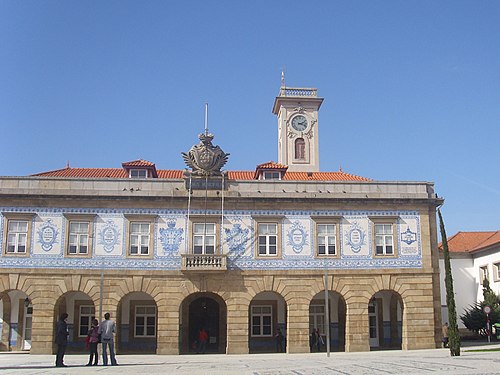
O município da Póvoa de Varzim é administrado por uma Câmara Municipal composta por nove vereadores. Existe uma Assembleia Municipal que é o órgão legislativo do município, constituída por 39 deputados, doze dos quais são presidentes das juntas de freguesia.
Depois das eleições autárquicas de 2009, cinco vereadores são do Partido Social Democrata, três do Partido Socialista e um do CDS - Partido Popular. O presidente da Câmara Municipal é Macedo Vieira, pelo PSD, que foi reconduzido para o cargo com 46,2% dos votos. A maioria das cadeiras da assembleia municipal e das juntas de freguesias são também dominadas pelo PSD. Desde as primeiras eleições livres com o fim do período do Estado Novo, que apenas partidos de direita dominam o município, a câmara foi governada pelo CDS entre 1976 e 1989 e desde então pelo PSD. O CDS viu a sua popularidade ter um declínio abrupto em 1997, passando desde esta altura a ser a terceira força política. Pelo contrário, o PSD conheceu nesse mesmo ano a sua primeira maioria absoluta com 62,4% dos votos.
Entre 1308 e 1836, o concelho era constituído apenas pela sede, cujo território foi sendo dilatado de forma a se aproximar do que se acreditava ser o território de Villa Euracini. Aver-o-Mar foi anexada como lugar, primitivamente, no século XVII devido a uma população crescente de pescadores-lavradores. Com a reforma administrativa do território em 1836, a Póvoa de Varzim passa a ser constituída por várias freguesias e o seu território dilata-se consideravelmente. Por outro lado, Caxinas e Poça da Barca, com populações piscatórias originárias da Póvoa de Varzim, continuam a ser administradas por Vila do Conde, apesar dos desejos centenários da Póvoa para que sejam integradas no seu município. A 15 de Março de 1858, um ofício do Governo Civil refere para que a Póvoa troque os lugares de Cerca e Quintela de Argivai (por serem contíguos a Vila do Conde), pelos de Poça da Barca e Regufe, tal como havia requerido. No entanto, no dia seguinte um novo ofício declara lesiva para Vila do Conde tal anexação, apesar dos moradores de Poça da Barca terem também requerido a anexação à Póvoa.
Educação

A Escola Superior de Estudos Industriais e Gestão (ESEIG), parte do Politécnico do Porto, foi fundada em 1990. A escola estava baseada em dois campus, um na Avenida Mouzinho de Albuquerque e outro em Vila do Conde, mas foi unificada num único campus em 2001.O novo campus tem 31544 m² e inclui equipamentos tais como um auditório e espaços de pesquisa. A ESEIG oferece educação pré-graduada e pós-graduada. As escolhas académicas centram-se em engenharia industrial, desenho industrial, engenharia biomédica, gestão, recursos humanos, contabilidade e finanças empresariais.
A Póvoa de Varzim tem escolas públicas, paroquiais e independentes espalhadas pela cidade e áreas rurais. A educação pública no município é providenciada por cinco agrupamentos verticais: Flávio Gonçalves, Cego do Maio, Aver-o-Mar, Campo Aberto e Rates. Estes agrupamentos reúnem jardins-de-infância e escolas até ao nono ano de diferentes espaços do concelho e são encabeçados pelas escolas Escolas de Educação Básica do 2.º e 3.°Ciclo que deram o nome aos respectivos agrupamentos. As escolas privadas na Póvoa de Varzim são primariamente geridas por paróquias ou católicos, mas o Grande Colégio da Póvoa de Varzim na área urbana e a Escola Agrícola Campo Verde são escolas independentes eminentes, para além do MAPADI que é um grande complexo para crianças com o síndroma de Down. O Colégio do Sagrado Coração de Jesus, onde estudou Agustina Bessa-Luís e as meninas da classe alta piscatória tem como objectivo ser uma escola católica de topo.
As escolas secundárias (do 10.º ao 12.º ano) estão situadas no centro da cidade, são elas a Escola Secundária Eça de Queirós e a Escola Secundária Rocha Peixoto. O Colégio de Amorim é uma escola independente na freguesia de Amorim que também oferece educação a nível secundário. A Eça de Queirós foi um liceu criado em 1904 e que ainda mantém a sua vocação humanista e a Rocha Peixoto era uma antiga escola industrial e comercial criada em 1924.
Infraestrutura

Transportes
A Póvoa de Varzim é servida por uma rede de transportes que emprega vias marítimas, terrestres e aéreas. A infraestrutura terrestre de acesso é composta por auto-estradas, o sistema de estradas nacionais e rede de metropolitano ligeiro. Estas infraestruturas e os terminais aeroporto, central de camionagem, marina e porto marítimo são utilizados diariamente por milhares de pessoas para aceder à cidade.
O transporte público dentro da cidade da Póvoa de Varzim é gerido predominantemente pela Litoral Norte - Transportes Urbanos da Póvoa de Varzim, as restantes linhas são geridas pela Transdev. A Central de Camionagem da Póvoa de Varzim é um término de camionetas e autocarros (ônibus) que providenciam transporte na região circundante, nomeadamente na zona rural do município, Porto, região do Minho e Galiza.
Situado a apenas 18 km do centro da cidade, o Aeroporto Internacional Sá Carneiro (OPO) é um dos principais aeroportos internacionais no país. O Aeródromo da Póvoa de Varzim, oficializado como S. Miguel de Laundos, é uma pista de 270 metros de comprimento para ultraleves e outros aviões de pequeno porte.
A linha B do Metro do Porto liga a Póvoa de Varzim à cidade do Porto e ao aeroporto em dois tipos de serviços, o normal e o "expresso". A linha opera numa antiga ferrovia que entrou em actividade em 1875 e foi desactivada em 2002 para dar lugar ao metro. O caminho-de-ferro foi expandido e chegou a Famalicão em 1881, tendo sido desactivado em 1995 e planeia-se a adaptação do canal para ciclovia. Os carros americanos apareceram em 1874 e permaneceram nas ruas da cidade até aos primeiros anos do século XX.
A cidade é ligada por estrada num eixo Norte-Sul desde Valença até ao Porto pela auto-estrada A28. As auto-estradas A7 e pela A11 cruzam a A28 e num eixo Este-Oeste, através do Sul e Norte da cidade, por essa ordem, ligam a cidade a Guimarães e Braga. Apesar de terem perdido utilidade como vias para médias e longas distâncias, as Estradas Nacionais adquiriram interesse municipal: a EN13, que corta a cidade a meio no sentido Norte-Sul, é usada pelos automobilistas provenientes das freguesias a norte e da cidade de Vila do Conde, a sul, para aceder ao centro da cidade. A EN205 e a EN206 são utilizadas pelos viajantes provenientes do interior do concelho.
Kaynak: Wikipedia – Póvoa de Varzim · CC BY-SA 4.0
Bucaklar

Belediyede 12 bucak (Por.: freguesia) yer almaktadır.
Kaynak: Wikipedia – Póvoa de Varzim · CC BY-SA 4.0
History
Castro Culture and Roman conquest
Discoveries of Acheulean stone tools suggest Póvoa de Varzim has been inhabited since the Lower Palaeolithic, around 200,000 BC. The first groups of shepherds settled on the coast where Póvoa de Varzim is now located between the 4th millennium and early 2nd millennium BC. A Neolithic-Calcolithic necropolis, with seven known burial mounds, can still be seen around São Félix Hill and Cividade Hill.
Widespread pillaging by rival and migrant tribes led the resident populations of the coastal plain of Póvoa de Varzim to raise a town atop the hill that stood next to the sea. The acropolis protection was reinforced by successive rings of walls and a trench at the base of the hill. Established by the 9th or 8th century B.C., the city area covered 12,000 m2 (3.0 acres) and had several hundred inhabitants. Its location near waterways helped it to maintain commercial relations with the Mediterranean civilizations, especially noticeable during the Carthaginian dominion of the southern Iberian Peninsula.
During the Punic Wars, the Romans became aware of the Castro region's rich deposits of gold and tin. Viriathus, leading Lusitanian troops, hindered the expansion of the Roman Republic north of the river Douro. His murder in 138 BC opened the way for the Roman legions. Over the following two years, Decimus Junius Brutus advanced into the Castro region from south of the Douro, crushed the Castro armies, and left Cividade de Terroso, in ruins.
The region was pacified during the reign of Caesar Augustus and the Castro people returned to the coastal plain, where Villa Euracini and Roman fish factories were built. With the annexation by the Roman Republic, trading supported regional economic development, with Roman merchants organized in true commercial companies who looked for monopoly in commercial relations.
Geography

Occupying an area of 82.1 km2 (31.7 sq mi), Póvoa de Varzim lies between the Cávado and Ave rivers, or, from a wider perspective, halfway between the Minho and Douro rivers on the northern coast of Portugal — the Costa Verde. It is bordered to the north by the municipality of Esposende, to the northeast by Barcelos, to the east by Vila Nova de Famalicão, and to the south by Vila do Conde. To the west, it has a shoreline on the Atlantic Ocean.
The rocky cliffs, common features downstream of the Minho's estuary, disappear in Póvoa de Varzim, giving way to a coastal plain. The plain is located in a cuspate foreland, an old marine plateau from the Plio-Pleistocene, conferring a sandy soil to the coastal lands. The sand dunes in the Northwestern coast formed during the Little Ice Age and started piling up in the 15th or 16th century. Wandering along the coast one discerns Cape Santo André, the tip of the cuspate foreland and the Avarus Promontory, referred to by Ptolemy.
São Félix Hill (202 m or 663 ft) and Cividade Hill (155 m or 509 ft) rise above the landscape. Despite their modest rise, the expanse of the plain makes them easy reference points on the horizon. The mountain chain known as Serra de Rates divides the municipality into two distinctive areas: the coastal plain and hills where the forests become more abundant and the soils have less sea influence. In this landscape dominated by the plains and low hills, only the hillside of Corga da Soalheira (150 m or 490 ft) in the interior, is dissimilar.
There are no large rivers, but abundant small water streams exist. Some of these streams are permanent, such as the Este River, which feeds into the Ave. The source of the Esteiro Stream is located at the base of Cividade Hill and empties at the beach of Aver-o-Mar, while the Alto River's source is at the base of São Félix and reaches the Atlantic at Rio Alto Beach. The land is well-irrigated, springs and wells are very common since underground water is often close to the surface.
Demographics
A native of Póvoa de Varzim is called a Poveiro which can be rendered into English as Povoan. According to the 2001 Census, there were 63,470 inhabitants that year, 38 848 (61.2%) of whom lived in the city. The number goes up to 100,000 if adjacent satellite areas are taken into account, ranking it as the seventh largest independent urban area in Portugal, within a polycentric agglomeration of about 3 million people, ranging from Braga to Porto. According to the EOCD methology, Póvoa de Varzim was the 13th largest Functional urban area of Portugal, hence a small urban area with 63,428 inhabitants, by including only its municipality.
The urban area has a population density of 3,035 people/km2 (7,860 people/mi2), while the rural and suburban areas have a density of 355.5/km2 (921/mi2). The rural areas away from the city tend to be scarcely populated, becoming denser near it. During the summer the resident population in the city triples; this seasonal movement from neighbouring cities is due to the draw of the beach and 29.9% of homes had seasonal use in 2001, the highest in Greater Porto. Póvoa de Varzim is the youngest city in the region with a birth rate of 13.665 and mortality rate of 8.330. Unlike other urban areas of greater Porto, it is not a satellite city. Significant commuting occurs only with Vila do Conde, an urban expansion area of Póvoa since the 18th century.
For centuries a fishing community of mostly Norman origin, where ethnic isolationism was a common practice, Póvoa de Varzim is today a cosmopolitan town, with people originating from the Ave Valley who settled in the coastal Northern districts during the 20th century, the ancient immigration from Galicia, Portuguese-Africans (who arrived in significant numbers after the independence of Angola and Mozambique) in the late 1970s. In 2017, Póvoa de Varzim had a legal foreign resident population of 1.5%, up from 1.4% in 2008, mostly including economic migrants and expatriates, it excludes those who obtained Portuguese citizenship and illegal migrants. Most of these were from Brazil, China, Ukraine, France, Spain, Mozambique, Angola, Romania, the United Kingdom and Cape Verde. Most of the growth in foreign population arrived from China, other Asian countries, France and other European countries. In 2017, 231 migrants moved to Póvoa de Varzim from Brazil, Ukraine and Venezuela; but also from Uzbekistan, Angola, and Georgia. Indonesian fishermen have been contracted to work in Póvoa de Varzim to redress labour shortages. Their arrival was negotiated directly with the Indonesian diplomatic authorities. Their numbers have grown to over 400, though some have moved on to other areas and even other European countries.
Economy

The economy of Póvoa de Varzim is driven by sales, manufacturing, construction, healthcare, agribusiness, fishing, and tourism. In the 2021 census, the unemployment rate, at 8.3%, compared to Porto Metropolitan Area at 9.6%, Northern Portugal at 8.4% and the national average at 8.1%. Póvoa de Varzim's purchasing power represented 0.6% of the total national purchasing power in 2019, up from 0.5% in 1993. However, per capita values were just 96.5% of the national average in 2019, up from 90.6% in 1993.
Comparing 2009 to 2020, the diversified economy of Póvoa de Varzim drifted away from construction (-70.3%), administrative (-55.6%), Entertainment
& leisure (-44.1%), and professional services (-22.9%) towards the growing fields of real estate (+73.5%), industrial sector (+47.3%), sales (+43.4%), Agribusiness & Fisheries (+41%), Healthcare (+31.9%) and Hospitality (+9.2%). quaternary sector (+41%) and Transport (+9.4%) are comparably minor yet growing economic activities.
Póvoa de Varzim's real estate development ranked as the fifth most active out of seventeen municipalities of Metropolitan Porto in 2015, when considering new homes. Reconstruction was mostly stagnant, and Póvoa de Varzim was eighth in overall activity.
Fisheries
The fact that it is a seaside city has shaped Póvoa de Varzim's economy: the fishing industry, from the fishing vessels that put in each day to the canning industry and to the city's fish market, beach agriculture, and seaweed-gathering for fertilizing fields are the result of its geography. Tourism and the related industries are more relevant in Póvoa's economy these days, as fisheries have lost importance. Nevertheless, the mean value of fish landed in 2004, in its seaport, was almost three times that of Matosinhos seaport and significantly higher in the average vessels' capacity. Its fishing productivity is also comparatively higher than the national average. A Poveira is a traditional Povoan canning factory and most of its production, 80 to 85%, is exported and deals with high-end brands in canned fish, for MDC markets. Export market brands include: Poveira, D'Henry IV, Ala-Arriba, Minerva, and Alva.
Government
Póvoa de Varzim is governed by a Câmara Municipal (City Council) composed of nine councilmen. A Municipal Assembly exists and it is the legislative body of the municipality.
After the first free elections, with the end of the Estado Novo period, only right-wing parties have governed the city: the city council was governed by the CDS between 1976 and 1989 and since then by the PSD. The CDS saw its popularity suffer an abrupt decline in 1997. On the other hand, the PSD in the same year achieved its first absolute majority with 62.4% of the votes. After the 2021 municipal elections, seven councilmen were members of the centre-right Partido Social Democrata (PSD), and two of the centre-left Partido Socialista (PS). The current mayor is Andrea Silva, for the PSD, elected with 40.6% of the votes, under a 58% turnout. The PSD holds a minority in the Municipal Assembly, but a majority in the administrative parishes. Póvoa de Varzim Assembly is singly elected and comprises 27 members, with the PSD holding 11 seats — 36.84%, the PS 9 seats — 29.15%, Chega 5 seats — 17.85%, the Liberals 1 seat — 5.26%, and the CDS 1 seat — 3.78%.
Póvoa de Varzim is the northernmost municipality in the Porto Metropolitan Area, about 27 km (17 mi) north of Porto. However, it is not a Porto's Commuter town. Póvoa de Varzim also used to be part of the former Association of Municipalities of the Ave Valley, along with neighbouring cities such as Vila do Conde, Guimarães, and Famalicão, with which it has the most important modern demographic links.
Since the establishment of the County of Portugal around 1095, Varzim was an administrative and military unit that stretched from the sea to Cividade de Terroso and São Félix Hills. Póvoa de Varzim was established as a municipality in 1308 with the election of a town hall judge and boundary exemption. As the town achieved broad self-government in the 16th century, restricted borders were created, which split the town itself and since disputed by the town hall. Over time, these were expanded to approach the medieval lordship boundaries. However, Caxinas and Poça da Barca, south expansion areas of Póvoa de Varzim in the 18th and 19th centuries with fisher populations from Póvoa, are administrated by Vila do Conde, in spite of the centuries-old requests of Póvoa de Varzim for these to be incorporated in its municipality. Inland, the parishes of Rio Mau, Touginhó, and Arcos are also historically disputed.
Cityscape

Urban morphology
Located in the coastal plain between the sea and hills, the city of Póvoa de Varzim has eleven Partes (parts), or districts. These districts are, in turn, part of two formal administrative structures known as freguesias (civil parishes): U.F. Póvoa de Varzim, Beiriz e Argivai and U.F. Aver-o-Mar, Amorim e Terroso. To the south, the city is extending out to combine with Vila do Conde.
The city started from an inland town that extended to the coast. The Bairro da Matriz, whose nucleus was the centre from whence the city grew, is intersected by 14th century narrow and twisted streets lined by single-family homes. The historical district has old buildings such as the sixteenth-century house in front of Matriz Church — the main church, the old Town Hall (14th century), the seventeenth-century Solar dos Carneiros and the house of Captain Leite Ferreira, and the eighteenth century Limas and the Coentrão Houses. The fishermen were grouped in the south coast, around Póvoa Cove (Enseada da Póvoa); The fisher district was already developed in the 18th century with its structure of narrow streets parallel to the coast.
Póvoa de Varzim City Centre or Centro is dominated by the service sector and by the shopping streets of Junqueira and Mousinho de Albuquerque Avenue. Praça do Almada, the central square, is tipped by City Hall, municipal departments, banks and other services. In the middle of the square, to the west, the Manueline pillory of Póvoa de Varzim stands. The Pelourinho, granted to the town in 1514, is a national monument representing the municipal emancipation of Póvoa de Varzim.
Bairro Norte, the beach district, is north of town and is densely occupied. Continuous to this area, the Agro-Velho beach district, mostly known as Nova Póvoa, is the area of the city with most high-rises, the largest of which the Nova Póvoa, with 30 floors and 95 metres (312 ft) high, complete in 1979, was the tallest building in Portugal until the year 2000 and is still today one of the five tallest buildings. Close at hand, Barreiros and Parque da Cidade are districts from the latest expansion.
Culture and contemporary life

Junqueira is Póvoa de Varzim's busiest shopping district, that cater to both the daily needs of residents and visitors. The main street, a shopping street since the 18th century, is a pedestrian area since 1955, one of the earliest in Portugal, and a model for other Portuguese cities that later did similar developments. It has about 1 km (0.62 mi) of pedestrian streets. Dotted with boutiques in old traditional buildings, Junqueira is renowned for its jewellery, with Ourivesaria Gomes was the goldsmith, The most notable of its goldsmiths is Ourivesaria Gomes, where, during the Estado Novo, important people of the regime were often seen with their families. Open for more than 100 years, Ourivesaria Gomes was the goldsmithery of the Portuguese Royal House, and it had kings, nobility and the clergy as customers. The bullet used for the assassination attempt of Pope John Paul II was encrusted in the crown of Our Lady of Fatima by them.
People in Póvoa de Varzim observe a variety of festivals each year. The major celebration is Póvoa de Varzim Holiday, dedicated to Saint Peter. Neighbourhoods are decorated and, on the night of 28 to 29 June, the population gathers in the streets and neighbourhoods compete in the rusgas carnival. The population behaves much like football supporters, when defending their preferred quarter. Families who emigrated to the United States and beyond, have been known to come back to Póvoa, time and again, simply to relish the spectacular feelings of excitement and community present at this festival. Easter Monday or Anjo festival is a remnant of a pagan festival, formerly called "Festa da Hera" (The Ivy Festival), in which several family picnics are held in the woods.
Carnival is a traditional festival in Póvoa de Varzim with the old Carnival Balls, masked people gathering in Rua da Junqueira until the late 1970s which led to the 1980s expensive carnival parades in the waterfront. The remains of such organized events are now celebrated spontaneously by the people who gather for a parade in Avenida dos Banhos. Despite not having any sort of advertising or media coverage, Póvoa's "Spontaneous Carnival" (Carnaval dos espontâneos) started to attract thousands of people.
Public services

Education
Higher education in the region has a dynamic history and growing availability. The Póvoa de Varzim/Vila do Conde campus, also known as Campus 2 of the Technical University of Porto (Universidade Técnica do Porto), houses the Superior School of Hospitality and Tourism — which maintains its polytechnic nature — and the Faculty of Media, Arts and Design. The latter faculty is centered around creativity and employability, offering academic choices focused on design, cinema, photography, multimedia, and the Web. Campus 2 was built in 2001, spanning 31,544 square metres (7.795 acres) with state-of-the-art facilities such as three amphitheaters, a large library, an auditorium, and a research space.
The campus's origins lie in the former School of Industrial Studies and Management founded in 1990, which originally offered undergraduate and postgraduate education in management and technology. Under the framework of the Technical University of Porto, the campus is poised for strategic expansion, adaptation, and further academic internationalization.
Póvoa de Varzim has public, denominational and independent schools in the city and outskirts. Public education in the municipality is provided by five school districts: Flávio Gonçalves, Cego do Maio, Aver-o-Mar, Campo Aberto, and Rates. These school districts arrange kindergartens and schools to the 9th grade of different locations of the municipality and are headed by Escolas de Educação Básica do 2.° e 3.°Ciclo (6th to the 9th-grade schools) that give the name to each district. Private schools are primarily run by Catholic parishes or groups, the most notable of which is the Colégio do Sagrado Coração de Jesus. The Grande Colégio da Póvoa de Varzim and Campo Verde School of Agriculture are eminent independent schools and MAPADI is a large facility and school for children with down syndrome.
Transport

Póvoa de Varzim has a transportation system that includes travel by sea, air, and land. On land, the city is connected by motorways, highways, and the Porto Metro. These transport options, along with the airport, bus station, marina, and harbour, are used daily by locals and visitors.
Public transport in the city is run by private companies. The Central de Camionagem bus station is a hub for city and long-distance buses, offering connections to nearby rural areas, Porto, the Minho region, and Galicia in Spain. Litoral Norte operates an urban bus network with five routes, while Linhares, the city’s oldest bus company, is now owned by Transdev.
Taxis in Póvoa de Varzim are black with an olive-green roof. The main taxi stands are in Praça do Almada, near the metro station, and at Largo das Dores. Taxi services, including Central Táxis Ribamar and Táxis Póvoa, also offer tours to attractions outside the city, such as the Discovery Age ship replica in Vila do Conde, the medieval churches of Rates and Rio Mau, the ancient settlement of Cividade de Terroso, and São Félix Hill.
Air
The Francisco Sá Carneiro Airport (IATA: OPO, ICAO: LPPR) is located 18 km (11 mi) south of Póvoa de Varzim. The airport, known outside the region as Porto Airport, is the second-busiest international airport in Portugal, moving over 10.7 million passengers in 2017. Using cars or taxis, it is fast accessible (17 minutes) via the A28 motorway, linked to the A41 motorway and the airport's drop-off and pick-up areas, or the EN13 highway, the later using the airport's EN107 accessway. Póvoa Aerodrome, officially known as S. Miguel de Laundos, is small-sized, with only 270 meters long for ultralight aviation and other small planes for leisure activities.
Rail
Line B of the Porto Metro connects the station at Póvoa de Varzim to Porto and its airport. It offers two services: a regular train and a faster shuttle called the Expresso. The line was built on an old railway that first opened in 1875. This railway was extended to Famalicão in 1881 but the extension was closed in 1995 and later became a walking and cycling path.
International relations
Atlantic Axis and European Regions
Póvoa de Varzim is part of the Eixo Atlântico ("Atlantic Axis"), a lobby of the most relevant Galician and Northern Portuguese cities. It also became a permanent member of the European Committee of the Regions, an assembly of local and regional representatives with a direct voice within the EU's institutional framework.
In 2016, the regional government of Príncipe Island, an autonomous region of São Tomé and Príncipe, and the municipality of Póvoa de Varzim, established a cooperation protocol, which has diverse fields of cooperation using human and technical resources. The protocol was signed after a visit to Póvoa de Varzim by the president of Príncipe Province, José Cardoso Cassandra.
Places of interest
Tourism industry is subdivided into gambling, hospitality, restaurants, beach bars and cafés. National visitors are prevalent and from diverse localities. In 1876, Ramalho Ortigão noticed that Póvoa was very popular in all social ranks in Northern Portugal.
In the contemporary period, the construction of motorways negatively affected overnight stays in local hotels. This has been leveled by a noticeable attraction of Portuguese living abroad and foreign tourists and the number of hotel rooms in 2014 increased to 1.774. Most of those tourists are French or from diverse countries in Northern Europe. International tourists sleeping in the city's hotels represented 35.1% of guests in 2013, up from 30.3% in 2001. In 2017, international tourists represented 55% of guests in the hospitality industry, which registed 250 thousand overnight stays almost the double of the 2012 statistics. Informal local accommodation, especially typical homes in rua Latino Coelho, is a popular alternative. In the summer of 2017, Póvoa de Varzim was the second location with the largest growth in the Portuguese AirBNB hospitality service. Póvoa de Varzim has the longest overnight stays for foreign tourists in Metropolitan Porto who stay, on average, 3 days.
International awareness is increasing and Povoa de Varzim was considered a 2022 hotspot for family vacations in Portugal by Yahoo! UK and Prima magazine, along with Lisbon, Albufeira, Porto, Carvoeiro and Viana do Castelo, highlighting the seven miles of soft golden sands and the historical side of the city, namely the important fishing and shipbuilding legacy. National and foreign visitors search the town for the numerous sandy beaches, sunbathing, sunsets over the ocean, relaxation and city trips. Walking from the beach promenades to the old town shopping street, the Junqueira, is particularly enjoyed, as is local food, most especially seafood. Since 1970, Póvoa de Varzim became widely popular in Northern Portugal for restaurants specialized in Portuguese Piri Piri Chicken, Cabidela chicken blood rice or codfish. Due to tourism, affluent pensioners from the Western World living in Póvoa de Varzim increased, triggering fears of renewed gentrification, the city hall responded with the planned construction of apartments with controlled prices for young Povoans in Penalves area.
Kaynak: Wikipedia – Póvoa de Varzim · CC BY-SA 4.0