Rapid City
Rapid City es una ciudad ubicada en el condado de Pennington en el estado estadounidense de Dakota del Sur.
Government administration · United States · 0 followers
Overview
Rapid City es una ciudad ubicada en el condado de Pennington en el estado estadounidense de Dakota del Sur. En el Censo de 2010 tenía una población de 67.956 habitantes y una densidad poblacional de 472,88 personas por km².
Interested in working with us in the future?
Follow to see new jobs and posts in your feed.
No news yet.
About

Rapid City es una ciudad ubicada en el condado de Pennington en el estado estadounidense de Dakota del Sur. En el Censo de 2010 tenía una población de 67.956 habitantes y una densidad poblacional de 472,88 personas por km².
Kaynak: Wikipedia · CC BY-SA 4.0
Geografía

Rapid City se encuentra ubicada en las coordenadas 44°4′16″N 103°13′5″O. Según la Oficina del Censo de los Estados Unidos, Rapid City tiene una superficie total de 143,71 km², de la cual 143,5 km² corresponden a tierra firme y (0,14%) 0,2 km² es agua.
Demografía
Según el censo de 2010, había 67.956 personas residiendo en Rapid City. La densidad de población era de 472,88 hab./km². De los 67.956 habitantes, Rapid City estaba compuesto por el 80.43% blancos, el 1.12% eran afroamericanos, el 12.38% eran amerindios, el 1.17% eran asiáticos, el 0.08% eran isleños del Pacífico, el 0.7% eran de otras razas y el 4.11% pertenecían a dos o más razas. Del total de la población el 4.14% eran hispanos o latinos de cualquier raza.
Ciudades hermanadas
Rapid City está hermanada con las siguientes ciudades:
Kaynak: Wikipedia – Rapid City (Dakota del Sur) · CC BY-SA 4.0
History

The public discovery of gold in 1874 by the Black Hills Expedition, led by George Armstrong Custer, brought a mass influx of European-American miners and settlers into Rapid City. A group of unsuccessful miners founded Rapid City in 1876, trying to create other chances; they promoted their new city as the "Gateway to the Black Hills"; it was originally known as Hay Camp. The "Gateway" nickname is shared by neighboring Box Elder. In February 1876, John Richard Brennan and Samuel Scott, with a small group of men, laid out Rapid City. It was eventually named for the spring-fed Rapid Creek that flows through it.
The land speculators measured off a square mile and designated the six blocks in the center as a business section. Committees were appointed to recruit prospective merchants and their families to locate in the settlement. Such merchants soon began selling supplies to miners and pioneers. The city's location on the edge of the Plains and Hills and its large river valley made it a natural hub for the railroads that were constructed in the late 1880s from both the south and east. By 1900, Rapid City had survived a boom and bust and was developing as an important regional trade center for the Upper Midwest.
The Black Hills had become popular in the late 1890s, but Rapid City became a more important destination in the 20th century. Local entrepreneurs promoted the sights, the availability of the automobile for individual transportation, and construction of improved roadways after World War I led to many more tourists to this area, including President Calvin Coolidge and the First Lady in summer 1927. Coolidge announced that he would not seek reelection in 1928 from his summer office in Rapid City. Gutzon Borglum, already a noted sculptor, began work on Mount Rushmore in 1927, and his son, Lincoln Borglum, continued the work after Gutzon's death in 1941. The work was halted due to the US need to invest in buildup for its entry into World War II; the sculpture was declared complete in 1941. However, Dinosaur Park, which was built in part to attract eventual Mount Rushmore tourists, is acknowledged for being the public attraction which began Rapid City's transformation into a major tourist destination. Dinosaur Park was initially built and opened in 1936, with overall construction being completed in 1938. Although tourism had sustained the city throughout the Great Depression of the 1930s, gasoline rationing during World War II decimated such travel. But investments in the defense industry and other war-related growth stimulated the placement of new military installations in the area, bringing more businesses and residents.
Geography

Rapid City is located in the shadow of Black Elk Peak, which at 7,242 feet (2,207 m), is the highest point east of the Rocky Mountains.
According to the United States Census Bureau, the city has an area of 56.049 square miles (145.17 km2), of which 55.987 square miles (145.01 km2) is land and 0.062 square miles (0.16 km2) (0.11%) is water.
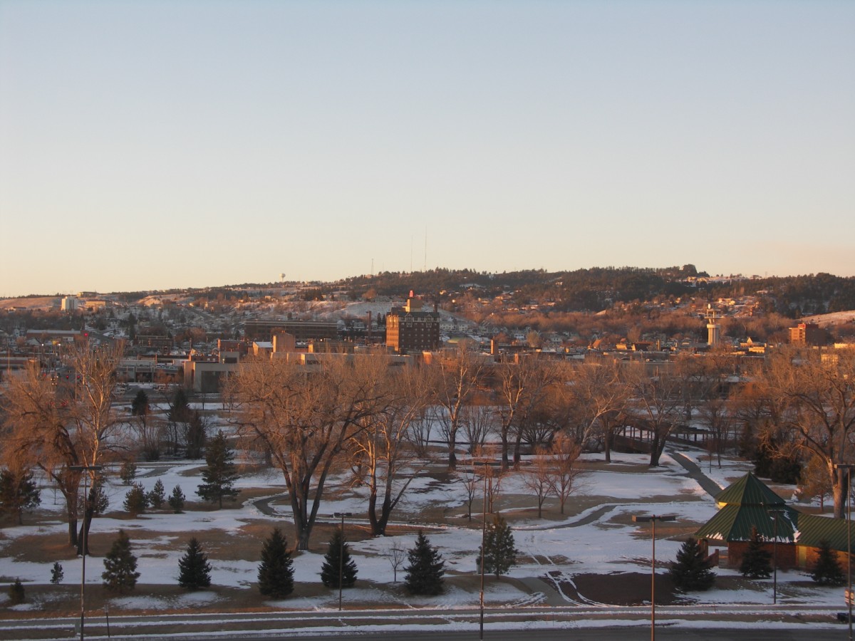
Rapid City is located on the eastern edge of the Black Hills, and has developed on each side of the Dakota Hogback. Rapid City's "Westside" is located in the Red Valley between the foothills of the Black Hills proper and the Dakota Hogback, so named for the red Spearfish formation soils and the way the valley completely encircles the Black Hills. Rapid City has expanded into the foothills, with developments having been built on both ridges and in valleys developed, especially in the last 20 years. This arid edge area has a higher risk of wildfire, as shown by the Westberry Trails fire in 1988.
Skyline Drive follows the summits of the Dakota Hogback south from near Rapid Gap (where Rapid Creek cuts through the Hogback) to a large high plateau that forms the current south edge of Rapid City. The Central and Eastern portions of Rapid City lie in the wide valley of Rapid Creek outside the Hogback. It includes a number of mesas rising a hundred feet or more above the floodplain.
Rapid Creek
Rapid Creek flows through Rapid City, emerging from Dark Canyon above Canyon Lake and flowing in a large arc north of downtown. It descends to the southeast where the valley widens. Since the flood damage of 1972, the city has prohibited most development in the floodplain of Rapid Creek. It has adapted this green space for public uses: a series of parks, arboretums, and bike trails, which have reconnected the city to the creek for residents.
To the north, a series of ridges separate Rapid Creek from Box Elder Creek. Both older and new residential areas and commercial areas have developed here, along I-90. To the south, the terrain rises more steeply to the southern widening of the Dakota Hogback into a plateau dividing the Rapid Creek drainage from Spring Creek.
Demographics
According to realtor website Zillow, the average price of a home as of September 30, 2026, in Rapid City was $360,913.
As of the 2024 American Community Survey, there were 33,659 estimated households in Rapid City with an average of 2.27 persons per household. The city has a median household income of $75,467. Approximately 10.6% of the city's population lives at or below the poverty line. Rapid City has an estimated 63.1% employment rate, with 37.1% of the population holding a bachelor's degree or higher and 93.5% holding a high school diploma. There were 37,216 housing units at an average density of 664.73 per square mile (256.65/km2).
The median age in the city was 37.1 years.
2020 census
As of the 2020 census, there were 74,703 people, 31,261 households, and 17,755 families residing in the city. The population density was 1,365.69 inhabitants per square mile (527.30/km2). There were 33,544 housing units at an average density of 613.24 per square mile (236.77/km2). The racial makeup of the city was 74.63% White, 1.50% African American, 13.19% Native American, 1.62% Asian, 0.07% Pacific Islander, 1.16% from some other races and 7.85% from two or more races. Hispanic or Latino people of any race were 5.30% of the population.
2010 census
As of the 2010 census, there were 67,956 people, 28,586 households, and 16,957 families residing in the city. The population density was 1,226.49 inhabitants per square mile (473.55/km2). There were 30,254 housing units at an average density of 546.03 per square mile (210.82/km2). The racial makeup of the city was 80.43% White, 1.12% African American, 12.38% Native American, 1.17% Asian, 0.08% Pacific Islander, 0.70% from some other races and 4.11% from two or more races. Hispanic or Latino people of any race were 4.14% of the population.
There were 28,586 households, of which 29.9% had children under the age of 18 living with them, 41.2% were married couples living together, 13.1% had a female householder with no husband present, 5.1% had a male householder with no wife present, and 40.7% were non-families. 32.9% of all households were made up of individuals, and 11.1% had someone living alone who was 65 years of age or older. The average household size was 2.29 and the average family size was 2.90.
Economy
Rapid City's economy is diverse, but industry is a small portion. Heavy and medium industrial activities include a Portland cement plant (constructed and owned for 84 years by the State of South Dakota and sold in 2003 to Grupo Cementos de Chihuahua, or GCC, a Mexican-based conglomerate); Black Hills Ammunition, an ammunition and reloading supplies manufacturing company; several custom sawmills, a lime plant, a computer peripheral component manufacturing plant, and several farm and ranch equipment manufacturers. Of particular note, this city is the center for the manufacture of Black Hills gold jewelry, a popular product with tourists and Westerners in general. The city is the site of the only American manufacturer of stamping machines used for the labeling of plywood and chipboard products.
Most gold mining has ceased in the Black Hills and was never conducted in or near Rapid City. Regional mining operations include for sand and gravel, as well as the raw materials for lime and Portland cement (including chemical-grade limestone, taconite iron ore, and gypsum) remains an important part of the economy.
The largest sector of the Rapid City economy is government services, including local, state, and federal. Major employers include Ellsworth Air Force Base, home of the 28th Bomb Wing flying the B-1B long-range bomber; the Army National Guard based at Camp Rapid and hosting annual exercises in the Black Hills, drawing troops from five to ten states; and various federal agencies, including the National Park Service, US Forest Service, and Indian Health Service.
Monument Health covers one of the largest geographic service areas in the United States. The health care sector employs more than 8,000 persons in the Rapid City area.
Tourism constitutes a major portion of the Rapid City economy, due to the proximity of Mount Rushmore, Sturgis, home of the Sturgis Motorcycle Rally; Deadwood, and other attractions in the Black Hills. Rapid City provides tourist services for Rally goers during the first week of August and can host conventions. Various minor attractions, including wildlife parks, specialty shops, caves, water parks, private museums, and other businesses are found in and near Rapid City.
Arts and culture

Cultural resources
Rapid City has invested in public sculptures, notably "The City of Presidents" series of life-sized bronze statues depicting each former President of the United States, located on street corners in the downtown area.
Library
The Rapid City Public Library is a major resource for education.
Sports
Active teams
The Rapid City Rush is a minor league ice hockey team in the ECHL, founded in 2008 and currently affiliated with the Calgary Flames of the National Hockey League since 2022.
American Legion Baseball has two teams, Post 22 and Post 320.
The Expedition League, a summer collegiate baseball league, is headquartered in Rapid City, although no teams currently play there.
Defunct teams
The Black Hills Posse was a professional basketball club that competed in the International Basketball Association beginning in the 1995–96 season.
The Black Hills Gold was a professional basketball club that competed in the International Basketball Association during the 1999–2000 season.
The Rapid City Flying Aces were an indoor football team that competed between 2000 and 2006 in the Indoor Football League, United Indoor Football, and National Indoor Football League, changing names from season to season.
The Rapid City Thrillers were a professional basketball club that competed in the Continental Basketball Association beginning in the 1987–88 season through the 1996–97 season.
The Rapid City Marshals were an indoor football team that competed in the Champions Indoor Football league from 2022 to 2024.
Other teams and events
Rapid City has two public high schools who field teams that compete in the SDHSAA, as well as two private schools.
The South Dakota Mines Hardrockers field 13 total varsity sports that compete at the NCAA Division II level in the Rocky Mountain Athletic Conference.
The Lakota Nation Invitational has been held annually at the Rushmore Plaza Civic Center since 1979.
Education
Rapid City institutions of higher education include the South Dakota School of Mines and Technology, Oglala Lakota College's He Sapa College Center, Black Hills State University - Rapid City University Center (includes classes and degrees through five other South Dakota post-secondary Institutions), National American University, Western Dakota Technical Institute, Black Hills Beauty College, John Witherspoon College, and several small sectarian preacher training schools.
Black Hills State University is located in nearby Spearfish and offers several classes in Rapid City. A South Dakota State University nurse training program is based in Rapid City.
In 2013, 26.6% of Rapid City residents 25 or older had earned a bachelor's degree or higher. This is on par with the average educational attainment in the United States. The highest rates of educational attainment in South Dakota can be found in metropolitan areas of Rapid City and Sioux Falls.
The area is served by the Rapid City Area Schools District 51-4. It operates the Rapid City School. In the 2025-26 academic year, the district reported a total of 12,040 students.
All of the city area, except for the airport territory, is within the Rapid City Area Schools District 51-4. There are three high schools within the district: Rapid City Central High School; Stevens High School; and Rapid City High School, which also houses the Performing Arts Center. The middle schools include East, North, South, Southwest, and West. There are 16 elementary schools within the district. These are Black Hawk, Canyon Lake, Corral Drive, General Beadle, Grandview, Horace Mann, Kibben Kuster, Knollwood Heights, Meadowbrook, Pinedale, Rapid Valley, Robbinsdale, South Canyon, South Park, Valley View, and Woodrow Wilson. The area containing the airport is in the Douglas School District 51-1.
Infrastructure

Public Transit
Rapid City is served by Rapid City Rapid Ride, which provides fixed route and demand response service to the region.
Rapid City has a municipally owned bus service, providing multiple bus stops and a headquarters in the city. It has limited city-to-city bus service along I-90. Charter bus services operate in the area, connecting Rapid City and Deadwood with cities in Colorado, Nebraska, and Iowa.
Intercity bus service to the city is provided by Jefferson Lines.
Air
Rapid City Regional Airport provides flights to the airline hub cities, and has general aviation operations, including wildfire fighting activities, and medical flight support to Rapid City medical facilities and regional Indian Health Service operations.
Railroads
Historically, Rapid City was primarily served by two railroads: the Chicago & North Western Railway and the Milwaukee Road. Following extensive restructuring in the industry in the late 20th and early 21st centuries, the city is now served only by the Rapid City, Pierre and Eastern Railroad (RCP&E). Rapid City has no passenger train service, and was last served in 1960 by the C&NW's Dakota 400, a daily train from Chicago to Rapid City via Rochester.
Power
Rapid City is located on the boundary of the Western and Eastern power grids. It is served by the hydroelectric plants of the two Mainstem dams on the Missouri River, and the large coal fields and power plants of the Powder River Basin of Wyoming. It is located where the two national power grids connect with each other, allowing switching of electrical power from east to west and vice versa. Rapid City had its own coal-fired power plant but could not afford to meet current air pollution standards and closed it. Closed for similar reasons were coal-fired power stations near Gillette, Wyoming. The Ben French power station located within city boundaries shut down September 2012, more than two years ahead of its scheduled shutdown. Rapid City now obtains much of its power from the Missouri dams and importing it from elsewhere. Following the shut down of the plants dependent on coal, electrical rates have increased. The city has had to spend more to import electricity over a longer distance.
Sister cities
Rapid City has three sister cities, as designated by Sister Cities International: